Category:Maps of ethnic groups in Serbia
Jump to navigation
Jump to search
Countries of Europe: Albania · Armenia‡ · Austria · Azerbaijan‡ · Belarus · Bosnia and Herzegovina · Bulgaria · Croatia · Cyprus‡ · Czech Republic · Estonia · Georgia‡ · Germany · Greece · Hungary · Italy · Kazakhstan‡ · Latvia · Lithuania · Moldova · Montenegro · Netherlands‡ · North Macedonia · Norway · Poland · Romania · Russia‡ · Serbia · Slovakia · Slovenia · Sweden · Turkey‡ · Ukraine · United Kingdom
Limited recognition: Abkhazia‡ · Kosovo · Transnistria
‡: partly located in Europe
Limited recognition: Abkhazia‡ · Kosovo · Transnistria
‡: partly located in Europe
Subcategories
This category has the following 15 subcategories, out of 15 total.
*
A
B
- Maps of the Bunjevci people (5 F)
C
- Maps of the Croats in Serbia (13 F)
- Maps of the Czechs in Serbia (3 F)
H
- Maps of the Hungarians in Serbia (15 F)
R
- Maps of the Romani in Serbia (4 F)
- Maps of the Rusyns in Serbia (6 F)
S
- Maps of the Slovaks in Serbia (14 F)
V
- Maps of the Vlachs in Serbia (24 F)
Media in category "Maps of ethnic groups in Serbia"
The following 81 files are in this category, out of 81 total.
-

-
 1910年奧匈帝國民族組成.svg 1,360 × 1,052; 919 KB
-
 Austria Hungary ethnic UK.svg 512 × 396; 287 KB
-
 Austria Hungary ethnic-ar.svg 1,360 × 1,052; 1,000 KB
-
 Austria Hungary ethnic-pt.svg 1,360 × 1,052; 911 KB
-
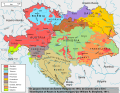
 Austria Hungary ethnic.svg 1,360 × 1,052; 1.56 MB
-
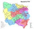 Banatul la 1743.jpg 2,526 × 2,168; 2.45 MB
-
 Census 2002 Eastern Serbia.png 1,070 × 515; 160 KB
-
 Census 2002 Serbia, ethnic map (by localities).png 1,687 × 2,423; 1.45 MB
-
 Census 2002 Serbia, ethnic map (by municipalities).png 1,845 × 2,600; 246 KB
-
 Ethnic groups in Easternmost Serbia, 1866.jpg 676 × 660; 136 KB
-

-
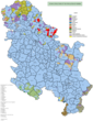
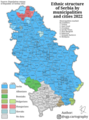 Ethnic structure of Serbia by municipalities and cities 2022.png 2,020 × 2,714; 2.16 MB
-
 Harta etnica a Timocului sarbesc la nivel de plasi, 1941.jpg 1,098 × 1,412; 616 KB
-
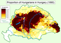 Hungarians in Hungary (1890).png 1,064 × 766; 159 KB
-
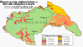 Hungary 1941 ethnic hu.svg 860 × 490; 339 KB
-
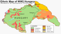 Hungary 1941 ethnic.svg 860 × 490; 475 KB
-
 Localitatile din Timocul bulgaresc locuite de romani, 1941.jpg 2,293 × 1,683; 1.05 MB
-
 Localitatile din Timocul sarbesc locuite de romani, 1941.jpg 4,445 × 4,327; 4.45 MB
-
 Macedonians in Serbia.png 419 × 600; 49 KB
-
 Medvedja harta.png 795 × 1,029; 353 KB
-
 Medvedja karta.png 1,050 × 1,444; 120 KB
-
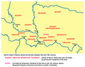
 Ottoman vojvodina ethnicity religion-sr.png 1,122 × 1,272; 90 KB
-
 Ottoman vojvodina ethnicity religion.png 1,122 × 1,272; 128 KB
-
 People declaring themselves Yugoslavs on the 2002 Serbian census.png 1,565 × 1,988; 226 KB
-
 Raska02i03.png 1,835 × 1,279; 465 KB
-
 RomaniansInBalkans.png 1,451 × 1,655; 379 KB
-
 Sandzak ethnic map.png 550 × 785; 65 KB
-
 Sandzak ethnic map2011.png 550 × 734; 58 KB
-
 Serbia ethnic 2011 01.png 728 × 690; 61 KB
-
 Serbia ethnic 2011 02.png 728 × 624; 51 KB
-
 Serbia ethnic 2011 03.png 728 × 690; 52 KB
-
 Serbia ethnic 6 8 century-sr.png 638 × 1,146; 66 KB
-
 Serbia ethnic 6 8 century.png 638 × 1,146; 68 KB
-
 Serbia ethnic dot map 100 people per dot.png 15,118 × 11,338; 15.33 MB
-
 Serbia Ethnic Map 1948 Srez.png 880 × 1,200; 262 KB
-
 Serbia Ethnic Map 1948.png 880 × 1,200; 546 KB
-
 Serbia Ethnic Map 1961.png 880 × 1,200; 662 KB
-
 Serbia Ethnic Map 1971.png 880 × 1,200; 653 KB
-
 Serbia Ethnic Map 1981.png 880 × 1,200; 655 KB
-
 Serbia Ethnic Map 1991.png 880 × 1,200; 667 KB
-
 Serbia Ethnic Map 2002.gif 440 × 600; 59 KB
-
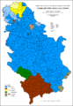
 Serbia Ethnic Map 2011.png 880 × 1,200; 646 KB
-
 Serbia ethnic02 rus.png 728 × 690; 48 KB
-
 Serbia ethnic02-sr.png 728 × 690; 54 KB
-
 Serbia ethnic02.png 728 × 690; 62 KB
-
 Serbiaetno03 200.PNG 1,845 × 2,600; 226 KB
-
 Serbien Ethnizitäten.png 2,362 × 2,035; 252 KB
-
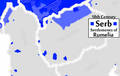 Serbrumelia18thc.png 330 × 210; 35 KB
-
 SerbsInBalkans.png 1,694 × 1,480; 469 KB
-
 Slavs Vojvodina01 map sr.png 1,020 × 836; 67 KB
-
 Slavs Vojvodina01 map.png 1,020 × 836; 69 KB
-
 Slavs Vojvodina02 map-sr.png 989 × 783; 63 KB
-
 Slavs Vojvodina02 map.png 989 × 783; 65 KB
-
 South slavic vojv map sr.png 1,259 × 1,161; 128 KB
-
 South slavic vojv map.png 1,259 × 1,161; 124 KB
-
 Srbija - Etnicki sastav po opstinama 1961 1.gif 2,000 × 2,890; 167 KB
-
 Srbija - Etnicki sastav po opstinama 1961 2.gif 2,000 × 2,890; 181 KB
-
 Srbija - Etnicki sastav po opstinama 1971 1.gif 2,000 × 2,890; 153 KB
-
 Srbija - Etnicki sastav po opstinama 1971 2.gif 2,000 × 2,890; 168 KB
-
 Srbija - Etnicki sastav po opstinama 1981 1.gif 2,000 × 2,890; 153 KB
-
 Srbija - Etnicki sastav po opstinama 1981 2.gif 2,000 × 2,890; 171 KB
-
 Srbija - Etnicki sastav po opstinama 1991 1-1.gif 2,000 × 2,890; 154 KB
-
 Srbija - Etnicki sastav po opstinama 1991 1-2.gif 2,000 × 2,890; 155 KB
-
 Srbija - Etnicki sastav po opstinama 1991 2-1.gif 2,000 × 2,890; 171 KB
-
 Srbija - Etnicki sastav po opstinama 1991 2-2.gif 2,000 × 2,890; 170 KB
-
 Srbija - Etnicki sastav po opstinama 2002 1.gif 2,000 × 2,890; 156 KB
-
 Srbija - Etnicki sastav po opstinama 2002 2.gif 2,000 × 2,890; 171 KB
-
 Srbija - Etnicki sastav po opstinama 2011 1-1.gif 2,000 × 2,890; 156 KB
-
 Srbija - Etnicki sastav po opstinama 2011 1-2.gif 2,000 × 2,890; 174 KB
-
 Srbija - Etnicki sastav po opstinama 2011 1.gif 2,000 × 2,890; 154 KB
-
 Srbija2002.pdf 1,239 × 1,752; 3.98 MB
-
 Srbijaetno53.png 1,924 × 2,789; 885 KB
-
 Vlachs in Serbia.png 2,772 × 2,627; 1.39 MB
-
 Yugo ethnic.gif 325 × 300; 15 KB
-
 Yugoslav ethnic map 2.jpg 849 × 1,102; 169 KB
-
 Yugoslavia 1998 ethnic map es.svg 1,734 × 1,256; 1.42 MB
-
 Yugoslavia 1998 ethnic map fr.svg 1,734 × 1,256; 1.03 MB
-
 Yugoslavia 1998 ethnic map pt.svg 1,734 × 1,256; 1.18 MB
-
 Yugoslavia ethnic map.jpg 1,643 × 1,715; 837 KB
-
 Јпг34.jpg 2,304 × 2,304; 897 KB
%27_(11244908104).jpg)


.png)
.png)


.png)


