Category:Maps of 14th-century Iberian Peninsula
Jump to navigation
Jump to search
| Preceded by: Maps of 13th-century Iberian Peninsula |
Maps of 14th-century Iberian Peninsula 1301 AD-1400 AD |
Succeeded by: Maps of 15th-century Iberian Peninsula |
Media in category "Maps of 14th-century Iberian Peninsula"
The following 10 files are in this category, out of 10 total.
-
 CastillaLeon 1360-es.svg 1,696 × 1,426; 913 KB
-
 CastillaLeon 1360-pt.svg 1,696 × 1,426; 1.04 MB
-
 CastillaLeon 1360.png 614 × 552; 702 KB
-
 Castilla1400.png 628 × 504; 513 KB
-
 Mapa distribucion feudal cadiz.JPG 1,118 × 430; 64 KB
-
 Navarra - Mapa de Merindades-y-Buenas-Villas (siglo XIV).png 3,125 × 3,125; 1.69 MB
-
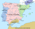
 Péninsule ibérique en 1314.png 2,000 × 1,500; 913 KB
-
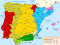
 Péninsule ibérique en 1350.png 2,000 × 1,500; 849 KB
-
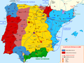 Péninsule ibérique en 1369.png 2,000 × 1,500; 963 KB
-
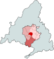 Tierra de Madrid en el siglo XIV.svg 351 × 384; 68 KB


.png)


