Category:Locator maps of counties of Idaho
Jump to navigation
Jump to search

States of the United States: Alabama · Alaska · Arizona · Arkansas · California · Colorado · Connecticut · Delaware · Florida · Georgia · Hawaii · Idaho · Illinois · Indiana · Iowa · Kansas · Kentucky · Louisiana · Maine · Maryland · Massachusetts · Michigan · Minnesota · Mississippi · Missouri · Montana · Nebraska · Nevada · New Hampshire · New Jersey · New Mexico · New York · North Carolina · North Dakota · Ohio · Oklahoma · Oregon · Pennsylvania · Rhode Island · South Carolina · South Dakota · Tennessee · Texas · Utah · Vermont · Virginia · Washington · West Virginia · Wisconsin · Wyoming
| NO WIKIDATA ID FOUND! Search for Locator maps of counties of Idaho on Wikidata | |
| Upload media |
English: Locator maps for counties in Idaho.
Media in category "Locator maps of counties of Idaho"
The following 44 files are in this category, out of 44 total.
-
 Map of Idaho highlighting Ada County.svg 5,061 × 7,805; 109 KB
-
 Map of Idaho highlighting Adams County.svg 5,061 × 7,805; 109 KB
-
 Map of Idaho highlighting Bannock County.svg 5,061 × 7,805; 109 KB
-
 Map of Idaho highlighting Bear Lake County.svg 5,061 × 7,805; 109 KB
-
 Map of Idaho highlighting Benewah County.svg 5,061 × 7,805; 109 KB
-
 Map of Idaho highlighting Bingham County.svg 5,061 × 7,805; 109 KB
-
 Map of Idaho highlighting Blaine County.svg 5,061 × 7,805; 109 KB
-
 Map of Idaho highlighting Boise County.svg 5,061 × 7,805; 109 KB
-
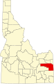
 Map of Idaho highlighting Bonner County.svg 5,061 × 7,805; 109 KB
-
 Map of Idaho highlighting Bonneville County.svg 5,061 × 7,805; 109 KB
-
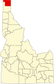 Map of Idaho highlighting Boundary County.svg 5,061 × 7,805; 109 KB
-
 Map of Idaho highlighting Butte County.svg 5,061 × 7,805; 109 KB
-
 Map of Idaho highlighting Camas County.svg 5,061 × 7,805; 109 KB
-
 Map of Idaho highlighting Canyon County.svg 5,061 × 7,805; 109 KB
-
 Map of Idaho highlighting Caribou County.svg 5,061 × 7,805; 109 KB
-
 Map of Idaho highlighting Cassia County.svg 5,061 × 7,805; 109 KB
-
 Map of Idaho highlighting Clark County.svg 5,061 × 7,805; 109 KB
-
 Map of Idaho highlighting Clearwater County.svg 5,061 × 7,805; 109 KB
-
 Map of Idaho highlighting Custer County.svg 5,061 × 7,805; 109 KB
-
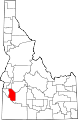
 Map of Idaho highlighting Elmore County.svg 5,061 × 7,805; 109 KB
-
 Map of Idaho highlighting Franklin County.svg 5,061 × 7,805; 109 KB
-
 Map of Idaho highlighting Fremont County.svg 5,061 × 7,805; 109 KB
-
 Map of Idaho highlighting Gem County.svg 5,061 × 7,805; 109 KB
-
 Map of Idaho highlighting Gooding County.svg 5,061 × 7,805; 109 KB
-
 Map of Idaho highlighting Idaho County.svg 5,061 × 7,805; 109 KB
-
 Map of Idaho highlighting Jefferson County.svg 5,061 × 7,805; 109 KB
-
 Map of Idaho highlighting Jerome County.svg 5,061 × 7,805; 109 KB
-
 Map of Idaho highlighting Kootenai County.svg 5,061 × 7,805; 109 KB
-
 Map of Idaho highlighting Latah County.svg 5,061 × 7,805; 109 KB
-
 Map of Idaho highlighting Lemhi County.svg 5,061 × 7,805; 109 KB
-
 Map of Idaho highlighting Lewis County.svg 5,061 × 7,805; 109 KB
-
 Map of Idaho highlighting Lincoln County.svg 5,061 × 7,805; 109 KB
-
 Map of Idaho highlighting Madison County.svg 5,061 × 7,805; 109 KB
-
 Map of Idaho highlighting Minidoka County.svg 5,061 × 7,805; 109 KB
-
 Map of Idaho highlighting Nez Perce County.svg 5,061 × 7,805; 109 KB
-
 Map of Idaho highlighting Oneida County.svg 5,061 × 7,805; 109 KB
-
 Map of Idaho highlighting Owyhee County.svg 5,061 × 7,805; 109 KB
-
 Map of Idaho highlighting Payette County.svg 5,061 × 7,805; 109 KB
-
 Map of Idaho highlighting Power County.svg 5,061 × 7,805; 109 KB
-
 Map of Idaho highlighting Shoshone County.svg 5,061 × 7,805; 109 KB
-
 Map of Idaho highlighting Teton County.svg 5,061 × 7,805; 109 KB
-
 Map of Idaho highlighting Twin Falls County.svg 5,061 × 7,805; 109 KB
-
 Map of Idaho highlighting Valley County.svg 5,061 × 7,805; 109 KB
-
 Map of Idaho highlighting Washington County.svg 5,061 × 7,805; 109 KB


