Category:King-Lincoln Bronzeville (Columbus, Ohio)
human settlement in Columbus, Ohio, United States of America | |||||
| Upload media | |||||
| Instance of | |||||
|---|---|---|---|---|---|
| Location | Columbus, Franklin County, Ohio | ||||
 | |||||
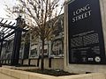
Just east of Downtown Columbus, King-Lincoln Bronzeville is bordered by the Mount Vernon neighborhood and Atcheson Street on the north, 20th Street on the east, Olde Towne East and Broad Street on the south, and I-71 on the west. The area was at one time much larger, including parts of what is now the Discovery District. The creation of I-71 significantly cut the area off from Downtown, causing socioeconomic decline and the growth of crime and violence. The neighborhood has become the focus of the city's revitalization efforts which include renovation of the historic Lincoln Theatre, construction of new condos and expansion of retail space along Mt. Vernon Avenue and Long Street, which hosts the annual Long Street Tour cycling event.
Subcategories
This category has the following 18 subcategories, out of 18 total.
B
- Bronzeville Growers’ Market (2 F)
D
- Dr. Lewis M. Early Residence (8 F)
F
- Frederick W. Schumacher mansion (11 F)
H
J
- Johnson-Campbell House (2 F)
- Joseph F. Firestone House (10 F)
K
- King Arts Complex (4 F)
L
M
- Mount Vernon Plaza (4 F)
O
- Ohio State East Hospital (9 F)
P
- Poindexter Village (5 F)
S
- St. Clair Hospital (2 F)
T
- Twenty-Third Street School (5 F)
Media in category "King-Lincoln Bronzeville (Columbus, Ohio)"
The following 52 files are in this category, out of 52 total.
-
 1032 E Long St.jpg 4,986 × 3,910; 9.83 MB
-
 1240 East Long Street.jpg 5,336 × 2,491; 9.12 MB
-

-
 Blanchard Columbus image 010.jpg 4,229 × 1,656; 977 KB
-
 Cana Bar.jpeg 640 × 640; 213 KB
-
 Champion Avenue School--Columbus, Ohio.jpg 2,288 × 1,712; 726 KB
-
 Columbus Metropolitan Library Wodland Park Branch.jpg 2,448 × 3,264; 535 KB
-
 Columbus Ohio, King Lincoln (Bronzeville).jpg 1,453 × 1,781; 427 KB
-
 Columbus, Ohio c. 1898 - 106.jpg 2,445 × 2,113; 842 KB
-
 Columbus, Ohio school 07.jpg 4,015 × 2,437; 1.2 MB
-
 D. Tod Gilliam home photograph.png 3,081 × 2,622; 6.76 MB
-
 E Long Street, King-Lincoln Bronzeville, Columbus, OH - 40418684000.jpg 3,264 × 2,448; 1.74 MB
-
 E Long Street, King-Lincoln Bronzeville, Columbus, OH.jpg 3,264 × 2,448; 1.69 MB
-
 E. Long Street, Columbus, Ohio 2.jpg 4,608 × 3,456; 3.74 MB
-
 E. Long Street, Columbus, Ohio.jpg 4,608 × 3,456; 3.58 MB
-
 E. Long Street, King-Lincoln (Bronzeville).jpg 3,456 × 4,608; 4.04 MB
-
 Eastwood Congregational Church.jpg 4,149 × 2,709; 1.06 MB
-
 Frank J. Kaufman House.jpg 2,816 × 2,112; 2.03 MB
-
 Frederick Prentiss House replacement.jpg 5,818 × 3,932; 13.48 MB
-
 H B Alexander house - DPLA - e7887c358365bf72d7d3ea5d26c5ce44.jpg 2,029 × 2,726; 1.77 MB
-
 King Lincoln (Bronzeville), Columbus, Ohio..jpg 4,608 × 3,456; 3.4 MB
-
 King Lincoln (Bronzeville), Columbus, Ohio.jpg 1,431 × 1,899; 501 KB
-
 King Lincoln District Library.jpg 3,456 × 4,608; 2.95 MB
-
 King-Lincoln 02.jpg 6,000 × 4,000; 12.46 MB
-
 King-Lincoln 13.jpg 4,328 × 3,784; 9.53 MB
-
 King-Lincoln 17.jpg 5,938 × 3,959; 13.26 MB
-
 King-Lincoln Bronzeville District.jpeg 692 × 519; 216 KB
-
 KLrowhomes.jpg 1,632 × 1,232; 386 KB
-
 KLUS.jpg 2,134 × 2,848; 1.18 MB
-
 Long Street Bridge.jpeg 640 × 480; 219 KB
-
 Los Potosinos Food Truck.jpeg 640 × 640; 232 KB
-
 M. E. Church, Mt. Vernon Ave. and 18th St., Columbus, O.jpg 3,288 × 2,064; 1.54 MB
-
 Mural on E. Long Street. Columbus, Ohio..jpg 4,608 × 3,456; 3.31 MB
-
 N 20th Street, King-Lincoln Bronzeville, Columbus, OH - 40418684470.jpg 3,264 × 2,448; 1.91 MB
-
 N 20th Street, King-Lincoln Bronzeville, Columbus, OH - 40418685750.jpg 2,448 × 3,264; 1.82 MB
-
 N 20th Street, King-Lincoln Bronzeville, Columbus, OH - 40418685930.jpg 2,448 × 3,264; 1.56 MB
-
 N 20th Street, King-Lincoln Bronzeville, Columbus, OH - 40418686230.jpg 2,448 × 3,264; 1.94 MB
-
 N 20th Street, King-Lincoln Bronzeville, Columbus, OH - 42225910751.jpg 3,264 × 2,448; 2.07 MB
-
 N 20th Street, King-Lincoln Bronzeville, Columbus, OH - 42225914731.jpg 3,264 × 2,448; 2.18 MB
-
 N 20th Street, King-Lincoln Bronzeville, Columbus, OH - 42225915431.jpg 3,264 × 2,448; 2.01 MB
-
 N 20th Street, King-Lincoln Bronzeville, Columbus, OH - 42225918161.jpg 3,264 × 2,448; 1.86 MB
-
 N 20th Street, King-Lincoln Bronzeville, Columbus, OH.jpg 3,264 × 2,448; 1.96 MB
-
 Pilgrim Missionary Baptist Church.jpg 5,046 × 3,595; 10.05 MB
-
 Prentiss-Tulford House site.jpg 2,816 × 2,112; 2.16 MB
-
 Sculpture - East Long Street, Columbus, Ohio.jpg 3,456 × 4,608; 3.83 MB
-
 Shiloh Baptist Church.jpg 3,872 × 2,592; 4.44 MB
-
 Spring and Long St bridges.jpg 4,000 × 2,250; 3.62 MB
-
 St. Mark's Masonic Temple No. 7 of the Prince Hall Free & Accepted Masons.jpg 6,000 × 4,000; 13.56 MB
-
 The Edna, Columbus, OH, US.jpg 4,777 × 4,002; 19.72 MB
-
 The Lincoln Cafe.jpeg 640 × 640; 236 KB
-
 Theresa Building, Columbus.jpg 6,016 × 4,000; 10.51 MB
-
 Views of Columbus, Ohio illustration 34.jpg 1,476 × 1,246; 281 KB


.jpg)


.jpg)


.jpg)


,_Columbus,_Ohio..jpg)
,_Columbus,_Ohio.jpg)


