Category:July 2006 in County Antrim
Jump to navigation
Jump to search
English: Images taken in County Antrim, Northern Ireland in this month of 2006 (not the date of the upload).
| Jan | Feb | Mar | Apr | May | Jun | Jul | Aug | Sep | Oct | Nov | Dec | ||
| ← | 38 | 48 | 10 | 35 | 37 | 24 | 53 | 216 | 56 | 18 | 18 | 25 | → |
|---|
Media in category "July 2006 in County Antrim"
The following 53 files are in this category, out of 53 total.
-
 225 at Cloghogue - geograph.org.uk - 315201.jpg 640 × 426; 152 KB
-
 Above Glenoe waterfall - geograph.org.uk - 212098.jpg 640 × 426; 186 KB
-
 Ballygally Head, Antrim coast road - geograph.org.uk - 212146.jpg 640 × 426; 130 KB
-
 Beach near Ballygalley - geograph.org.uk - 210818.jpg 640 × 480; 137 KB
-
 Beach south of Glenarm - geograph.org.uk - 210999.jpg 640 × 480; 129 KB
-
 Boats in Ballintoy Harbour - geograph.org.uk - 204893.jpg 640 × 300; 38 KB
-
 Bridge at Glenarm - geograph.org.uk - 211010.jpg 640 × 480; 87 KB
-
 Browns Bay, Islandmagee - geograph.org.uk - 209605.jpg 640 × 426; 148 KB
-
 Carrick a Rede.jpg 640 × 479; 173 KB
-
 Carrickfergus Castle 02.jpg 1,280 × 853; 249 KB
-
 Carrickfergus marina - geograph.org.uk - 206110.jpg 640 × 426; 128 KB
-
 Carrickfergus marina - geograph.org.uk - 206725.jpg 640 × 426; 142 KB
-
 Coastal Road and Beach - geograph.org.uk - 210820.jpg 640 × 480; 103 KB
-

-
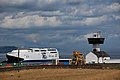
 Continental Airlines 757 departing Belfast.jpg 2,304 × 1,536; 653 KB
-
 Derelict House - geograph.org.uk - 212241.jpg 640 × 480; 130 KB
-
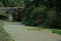
 Disused Lagan Navigation near Hilden - geograph.org.uk - 314936.jpg 640 × 426; 140 KB
-
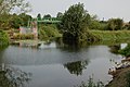
 Disused Lagan Navigation, Goudy Bridge - geograph.org.uk - 195708.jpg 640 × 426; 146 KB
-
 Donkeys on Divis - geograph.org.uk - 221719.jpg 640 × 480; 83 KB
-
 Ferris Point lighthouse, Larne Lough - geograph.org.uk - 209647.jpg 640 × 426; 117 KB
-
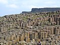
 Giants Causeway cellules polygonales.JPG 2,048 × 1,536; 1.15 MB
-
 Giants Causeway chemin d'accès.JPG 2,048 × 1,536; 824 KB
-
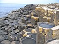
 Giants Causeway détail de la chaussée.JPG 2,048 × 1,536; 1,014 KB
-
 Giants Causeway rocher central.JPG 2,048 × 1,536; 886 KB
-
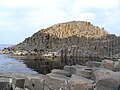
 Giants Causeway vue générale.JPG 2,048 × 1,536; 1.04 MB
-
 Glenarm Beach - geograph.org.uk - 212223.jpg 640 × 480; 111 KB
-
 Glenarm Harbour - geograph.org.uk - 211006.jpg 640 × 480; 139 KB
-
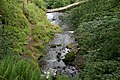
 Glenoe glen (1) - geograph.org.uk - 205774.jpg 640 × 426; 175 KB
-
 Glenoe waterfall (2) - geograph.org.uk - 205763.jpg 640 × 426; 162 KB
-
 Hancock Street, Lisburn - geograph.org.uk - 196184.jpg 640 × 426; 167 KB
-
 Hollow Road, Islandmagee - geograph.org.uk - 209600.jpg 640 × 426; 151 KB
-
 Kilroot Power.jpg 1,280 × 853; 198 KB
-
 Lisburn lock, disused Lagan Navigation - geograph.org.uk - 195629.jpg 640 × 426; 145 KB
-
 McCrea's Brae, Whitehead - geograph.org.uk - 206731.jpg 640 × 426; 127 KB
-
 Morning Mist - geograph.org.uk - 492862.jpg 640 × 426; 84 KB
-
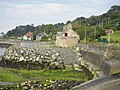
 Old lime kiln, Portmuck, Islandmagee - geograph.org.uk - 205638.jpg 640 × 426; 174 KB
-
 Old Limestone Workings - geograph.org.uk - 211003.jpg 640 × 480; 79 KB
-
 Onur Air,landing,Belfast..jpg 2,272 × 1,704; 925 KB
-
 Path to Skernaghan Point, Islandmagee (1) - geograph.org.uk - 209611.jpg 640 × 426; 178 KB
-
 Path to Skernaghan Point, Islandmagee (2) - geograph.org.uk - 209622.jpg 640 × 426; 168 KB
-
 Portmuck harbour, Islandmagee - geograph.org.uk - 205632.jpg 640 × 426; 148 KB
-
 Portmuck Road, Islandmagee (2) - geograph.org.uk - 237655.jpg 640 × 426; 155 KB
-
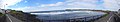 Portrush panorama.jpg 4,129 × 773; 726 KB
-
 Princess Victoria memorial, Larne - geograph.org.uk - 206083.jpg 640 × 426; 120 KB
-
 Rocky Beach near Ballygalley - geograph.org.uk - 210815.jpg 640 × 480; 65 KB
-
 Rocky coast, Islandmagee - geograph.org.uk - 209628.jpg 640 × 426; 177 KB
-
 Rough Grazing on Divis - geograph.org.uk - 310287.jpg 639 × 433; 71 KB
-
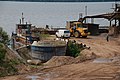 Sand quay, Lough Neagh - geograph.org.uk - 197818.jpg 640 × 426; 151 KB
-
 Shane's Hill Road, Larne (1) - geograph.org.uk - 206745.jpg 640 × 426; 139 KB
-
 Slemish - geograph.org.uk - 206769.jpg 640 × 426; 152 KB
-
 The "Lagan Belle" at Lisburn - geograph.org.uk - 394655.jpg 640 × 426; 156 KB
-
 The Moyle Interconnector - geograph.org.uk - 205643.jpg 640 × 426; 154 KB
-
 Whitehead railway station - geograph.org.uk - 212034.jpg 640 × 426; 158 KB


_-_geograph.org.uk_-_205774.jpg)
_-_geograph.org.uk_-_205763.jpg)


_-_geograph.org.uk_-_209611.jpg)
_-_geograph.org.uk_-_209622.jpg)

_-_geograph.org.uk_-_237655.jpg)


_-_geograph.org.uk_-_206745.jpg)


