Category:Historical maps of ethnic groups in Turkey
Jump to navigation
Jump to search
Countries of Asia: Turkey‡
‡: partly located in Asia
‡: partly located in Asia
Countries of Europe: Albania · Austria · Bosnia and Herzegovina · Bulgaria · Croatia · Czech Republic · Greece · Hungary · Italy · Lithuania · Moldova · Montenegro · North Macedonia · Poland · Romania · Serbia · Slovakia · Slovenia · Turkey‡ · Ukraine
Limited recognition: Kosovo · Transnistria
‡: partly located in Europe
Limited recognition: Kosovo · Transnistria
‡: partly located in Europe
Media in category "Historical maps of ethnic groups in Turkey"
The following 37 files are in this category, out of 37 total.
-

-
 A Synvet 1877.jpg 1,339 × 1,381; 857 KB
-
 Anatolia ethnic map 1914 french 1.jpg 3,584 × 3,290; 1,022 KB
-
 Anatolia ethnic map 1914 ottoman turkish.jpg 3,857 × 2,966; 1.08 MB
-
 Balkans-ethnic (1861) (2).jpg 1,864 × 1,915; 2.01 MB
-
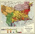
 Balkans-ethnic (1861).jpg 6,280 × 5,072; 3.98 MB
-
 Balkans-ethnic (1877).jpg 2,020 × 2,084; 1.14 MB
-
 Balkans-ethnique.JPG 1,258 × 1,266; 457 KB
-
 Bulgarians in 1912.jpg 2,696 × 1,964; 2.05 MB
-
 Cappadocian Greek homeland.JPG 664 × 339; 22 KB
-
 CarlSaxET1877.jpg 3,100 × 2,968; 7.57 MB
-

-
 Edward Stanford 1877 - mistakes.JPG 1,350 × 1,589; 1.05 MB
-
 Edward Stanford 1877.jpg 1,350 × 1,287; 1.17 MB
-
 Ernst-Ravenstein-Balkans-Ethnic-Map-1880.jpg 716 × 563; 160 KB
-
 Ethnographic map Ami Boué, 1847.jpg 2,364 × 2,348; 1.83 MB
-
 Ethnographic map of the Ardahan Okrug-1902.png 1,174 × 1,270; 1.95 MB
-
 Ethnographic map of the Kaghizman Okrug-1902.png 1,450 × 812; 1.61 MB
-
 Ethnographic map of the Kars Oblast (1902)-map legend-1.png 757 × 686; 433 KB
-
 Ethnographic map of the Kars Oblast (1902)-map legend-2.png 815 × 231; 153 KB
-
 Ethnographic map of the Kars Oblast-1902 - clipped.png 2,082 × 2,275; 5.31 MB
-
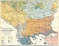
 Ethnographic map of the Kars Oblast-1902.png 4,956 × 3,361; 11.57 MB
-
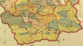
 Ethnographic map of the Kars Okrug-1902.png 1,350 × 1,173; 2.35 MB
-
 Ethnographic map of the Oltu Okrug-1902.png 829 × 843; 985 KB
-
 Ethnographic map of the South Balkans, Pallas Nagy Lexikon, 1897.jpg 613 × 791; 580 KB
-
 Greece at the time of the Dorian Migration (Spruner-Menke, Atlas Antiquus, 1865).jpg 6,935 × 5,554; 28.82 MB
-
 Karamanlides homeland.png 528 × 268; 24 KB
-
 NationalitiesOfSoutheasternEuropePallasNagyLexikon.jpg 695 × 1,136; 700 KB
-
 RizMap19.jpg 4,056 × 4,122; 5.67 MB
-
 RizMap22.jpg 770 × 600; 172 KB
-
 RizMap23.jpg 3,200 × 3,110; 6.71 MB
-
 RizMap24.jpg 2,046 × 1,839; 2.78 MB
-
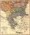
 Subject Nationalities of the German Alliance (1917) (cropped).jpg 4,480 × 2,739; 4.79 MB
-
 The Balkan Peninsula, Distribution of Races. EB 1911.png 1,057 × 1,510; 91 KB
-

-
 Trabzon Vilayeti nüfus Ottoman population 1914.png 685 × 378; 48 KB
-
 Этнографическая карта Карсской области (1880 г.).jpg 1,711 × 1,768; 925 KB


_(2).jpg)
.jpg)
.jpg)


.jpg)


-map_legend-1.png)


.jpg)


_(cropped).jpg)


.jpg)
-map_legend-2.png)