Category:Historical maps of ethnic groups in Lithuania
Jump to navigation
Jump to search
Countries of Europe: Albania · Austria · Bosnia and Herzegovina · Bulgaria · Croatia · Czech Republic · Greece · Hungary · Italy · Lithuania · Moldova · Montenegro · North Macedonia · Poland · Romania · Serbia · Slovakia · Slovenia · Turkey‡ · Ukraine
Limited recognition: Kosovo · Transnistria
‡: partly located in Europe
Limited recognition: Kosovo · Transnistria
‡: partly located in Europe
Media in category "Historical maps of ethnic groups in Lithuania"
The following 10 files are in this category, out of 10 total.
-
 Litauen BV042512936.jpg 5,619 × 4,825; 2.29 MB
-
 Atlas of population of the West Russian region of confessions 1864.jpg 7,192 × 9,671; 18.83 MB
-
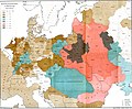
 Congress Poland and Lithuanian governorates - by Alexander Voschinin - 1851 AD.jpg 3,743 × 3,095; 2.62 MB
-
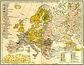 Europe ethnic map 1897 (hungarian).jpg 2,316 × 1,800; 907 KB
-
 Juden 1881.JPG 4,782 × 3,936; 3.96 MB
-
 Litauen BV042518396.jpg 3,722 × 3,340; 2.25 MB
-
 Litauen BV044875323.jpg 4,000 × 5,821; 2.47 MB
-
 Mapa rozsiedlenia ludności polskiej na terenie Litwy w 1929.jpg 9,754 × 7,382; 9.79 MB
-
 Polska1912.jpg 2,180 × 1,941; 811 KB
-
 Rus-10c-ethn.png 2,241 × 2,731; 257 KB


.jpg)


