Category:Geology of Scotland
Jump to navigation
Jump to search
national geology | |||||
| Upload media | |||||
| Subclass of | |||||
|---|---|---|---|---|---|
| Location |
| ||||
| |||||
Scotland | ||
|---|---|---|
|

Subcategories
This category has the following 76 subcategories, out of 76 total.
+
A
B
C
- Concretions in Scotland (2 F)
D
E
F
G
H
I
J
K
L
M
N
O
- Old Man of Storr (106 F)
- Ord Window (2 F)
P
Q
R
S
- Sinkholes in Scotland (9 F)
T
V
W
Media in category "Geology of Scotland"
The following 200 files are in this category, out of 244 total.
(previous page) (next page)-
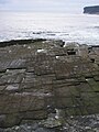
 "Organ Pipes" at Kilchattan - geograph.org.uk - 4827.jpg 640 × 339; 201 KB
-
 "The Prison", Quiraing - geograph.org.uk - 1075187.jpg 640 × 415; 78 KB
-
 'Coral Boulders' - geograph.org.uk - 868374.jpg 640 × 440; 289 KB
-
 2011 Argyllshire Glen Coe banana rock Clachaig Gully 26-05-2011 16-58-08.jpg 4,288 × 2,848; 4.57 MB
-
 2011-05 Schotland Glen Coe banana rock Clachaig Gully 26-05-2011 16-58-08.png 4,288 × 2,848; 24.89 MB
-
 575016-Theory of the Earth JamesHutton.jpg 946 × 399; 53 KB
-
 A' Cheir Ghorm - geograph.org.uk - 14084.jpg 640 × 427; 67 KB
-
 Altered serpentinite Druim nam Buraich.JPG 3,648 × 2,736; 3.66 MB
-
 Ancient sand dunes - geograph.org.uk - 1156217.jpg 640 × 480; 68 KB
-
 Arete to east of Corrie Laggan ,Skye - geograph.org.uk - 16970.jpg 640 × 425; 104 KB
-
 Basalt dyke, Whiting Bay - geograph.org.uk - 530283.jpg 480 × 640; 91 KB
-
 Beinn nan Caorach - geograph.org.uk - 1348759.jpg 640 × 427; 251 KB
-
 Bixter Quarry, Shetland - geograph.org.uk - 226200.jpg 640 × 480; 76 KB
-

-

-
 Bulletin of the Geological Society of America (1917) (20423378126).jpg 3,344 × 2,004; 1.12 MB
-
 Catpund Quarry, Shetland - geograph.org.uk - 226214.jpg 640 × 480; 153 KB
-
 Cave at Clashach Cove - geograph.org.uk - 185464.jpg 640 × 480; 102 KB
-
 Cliff "features" at Dunnet Head - geograph.org.uk - 873188.jpg 640 × 458; 107 KB
-
 Cliff at Clashach Cove by Hopeman - geograph.org.uk - 111953.jpg 640 × 480; 118 KB
-
 Cnoc na Coinnich - geograph.org.uk - 457000.jpg 640 × 480; 90 KB
-
 Cormorants' Rock - geograph.org.uk - 1613347.jpg 640 × 480; 51 KB
-
 Cruachan Mìn - geograph.org.uk - 457908.jpg 640 × 480; 100 KB
-
 Deep cleft on Lismore - geograph.org.uk - 952018.jpg 640 × 474; 52 KB
-
 Dunnet Head 05.jpg 4,272 × 2,848; 1.89 MB
-
 Dunnet Head cliffs - geograph.org.uk - 1387084.jpg 640 × 428; 74 KB
-
 Dunnet Head view 061915.jpg 3,872 × 2,592; 6.29 MB
-

-
 Dyke on Beinn Uamha - geograph.org.uk - 32655.jpg 640 × 407; 81 KB
-
 Dyke, Bàgh an Dà Dhoruis - geograph.org.uk - 761488.jpg 640 × 480; 79 KB
-
 East Kirkton Quarry - geograph.org.uk - 3670266.jpg 640 × 480; 614 KB
-
 East Kirkton Quarry - geograph.org.uk - 3670280.jpg 480 × 640; 526 KB
-
 Esker in Glen Lednock - geograph.org.uk - 109522.jpg 480 × 640; 75 KB
-
 Exit from the Vat - geograph.org.uk - 236690.jpg 427 × 640; 282 KB
-
 Fife Coastal Path.jpg 1,496 × 1,122; 537 KB
-
 Findlater Castle - geograph.org.uk - 1761408.jpg 640 × 427; 276 KB
-
 Findlater Castle - geograph.org.uk - 1761500.jpg 640 × 425; 271 KB
-
 First Foot, Fossil Tree - geograph.org.uk - 654691.jpg 480 × 640; 106 KB
-
 Fish Craig, Dunnet Head - geograph.org.uk - 61159.jpg 640 × 480; 88 KB
-
 Folded Precambrian Gneiss near Port Nis in Scotland.jpg 1,600 × 1,200; 1.02 MB
-
 Folds - geograph.org.uk - 1273160.jpg 640 × 427; 303 KB
-
 Folds - geograph.org.uk - 223998.jpg 640 × 403; 256 KB
-
 Folds in Gneiss - geograph.org.uk - 1370873.jpg 480 × 640; 336 KB
-
 Footpath From Burg, Ladder - geograph.org.uk - 185216.jpg 640 × 480; 137 KB
-
 Fractured Clast in Devonian conglomerate Conic Hill.JPG 3,648 × 2,736; 3.42 MB
-
 Gearraidh a Siar - geograph.org.uk - 1351452.jpg 640 × 427; 274 KB
-
 Giants' chessboard - geograph.org.uk - 1311681.jpg 640 × 408; 44 KB
-
-
 Glen Geusachan and the Devils Point - geograph.org.uk - 10134.jpg 640 × 427; 64 KB
-
 Glencoul Thrust - geograph.org.uk - 9032.jpg 640 × 453; 280 KB
-
 Granite from Aberdeen, World Museum Liverpool.JPG 4,320 × 3,240; 3.42 MB
-
 Granite Mountains - geograph.org.uk - 2358361.jpg 800 × 531; 127 KB
-
 GraphCoastalStructuresScotland.gif 414 × 487; 86 KB
-
 Great Glen Fault map.png 2,455 × 2,590; 1.18 MB
-
 Gsglogo new.jpg 1,083 × 375; 966 KB
-
 Hawk's Nib - geograph.org.uk - 176663.jpg 640 × 427; 86 KB
-
 Holm at Skaw banks - geograph.org.uk - 521879.jpg 640 × 426; 66 KB
-

-
 Horseofcopinsay3.jpg 640 × 410; 118 KB
-
 Igneous (dolerite) compound dyke - geograph.org.uk - 44623.jpg 480 × 640; 115 KB
-
 Inchbae Augen Gneiss - geograph.org.uk - 823011.jpg 640 × 427; 308 KB
-
 Joints Caithness.JPG 1,536 × 2,048; 1.38 MB
-
 Lady Bighouse.jpg 640 × 480; 98 KB
-
 Landslips Ben Tianavaig. - geograph.org.uk - 68930.jpg 640 × 480; 62 KB
-
 Lewisian Gneiss - geograph.org.uk - 1346868.jpg 427 × 640; 263 KB
-
 Lewisian Gneiss - geograph.org.uk - 486896.jpg 480 × 640; 125 KB
-
 Logie Head - geograph.org.uk - 967108.jpg 640 × 416; 243 KB
-
 Lower Devonian sandstone & conglomerate Bealach Ard.JPG 3,648 × 2,736; 3.98 MB
-
-
 Mesozoic sediments on Rubha nan Fear - geograph.org.uk - 1752085.jpg 2,880 × 2,160; 1.63 MB
-
-
 Millburn Geo - geograph.org.uk - 8684.jpg 640 × 316; 148 KB
-
 Minor thrust monocline.JPG 1,536 × 2,048; 1.3 MB
-
 Muckle Rock - geograph.org.uk - 593932.jpg 640 × 235; 122 KB
-
 MyrmekiteQMDpor.png 375 × 384; 141 KB
-
 Ness of Portnaculter - composition - geograph.org.uk - 286793.jpg 640 × 480; 200 KB
-
 Ness of Portnaculter shingle - geograph.org.uk - 286788.jpg 640 × 480; 193 KB
-
 Newton Point (Arran) Hutton´s Unconformity.jpg 7,063 × 3,024; 21.68 MB
-
 Noup of Noss.jpg 528 × 348; 167 KB
-
 Old Red Sandstone at Auchmithie in Scotland.jpg 4,288 × 2,848; 10.91 MB
-
 Ox Bow lake forming on the Riereach^ - geograph.org.uk - 702966.jpg 640 × 426; 109 KB
-
 Patterned ground, Beinn Bhan - geograph.org.uk - 1397150.jpg 640 × 427; 73 KB
-
 Pennan - Scotland - panoramio.jpg 3,872 × 2,592; 4.39 MB
-
 Pipe rock, SE ridge, Maol Chean-dearg. - geograph.org.uk - 230021.jpg 480 × 640; 315 KB
-

-
 Roche moutonnée - geograph.org.uk - 484690.jpg 640 × 480; 173 KB
-
 Roches Moutonnées, an explanation - geograph.org.uk - 242455.jpg 640 × 426; 119 KB
-
 Rockhead at Sandside Bay, Caithness, Scotland.jpg 1,536 × 2,048; 1.49 MB
-
 Rocks of Northern Scotland - geograph.org.uk - 1455797.jpg 640 × 424; 114 KB
-
 Rubha Mhàirtein - geograph.org.uk - 1750116.jpg 1,280 × 1,000; 489 KB
-
 Rynian (Rynie) Chert Thin Section (Rhynia gwynne-vaughanii) - 1.tif 2,560 × 1,920; 14.06 MB
-
 Rynian (Rynie) Chert Thin Section (Rhynia gwynne-vaughanii) - 10.tif 19,044 × 3,676; 88.38 MB
-
 Rynian (Rynie) Chert Thin Section (Rhynia gwynne-vaughanii) - 11.tif 4,516 × 4,500; 27.74 MB
-
 Rynian (Rynie) Chert Thin Section (Rhynia gwynne-vaughanii) - 2.tif 2,560 × 1,920; 14.06 MB
-
 Rynian (Rynie) Chert Thin Section (Rhynia gwynne-vaughanii) - 3.tif 2,560 × 1,920; 14.06 MB
-
 Rynian (Rynie) Chert Thin Section (Rhynia gwynne-vaughanii) - 4.tif 2,560 × 1,920; 14.06 MB
-
 Rynian (Rynie) Chert Thin Section (Rhynia gwynne-vaughanii) - 5.tif 2,560 × 1,920; 14.06 MB
-
 Rynian (Rynie) Chert Thin Section (Rhynia gwynne-vaughanii) - 6.tif 2,560 × 1,920; 14.06 MB
-
 Rynian (Rynie) Chert Thin Section (Rhynia gwynne-vaughanii) - 7.tif 2,560 × 1,920; 14.06 MB
-
 Rynian (Rynie) Chert Thin Section (Rhynia gwynne-vaughanii) - 8.tif 9,676 × 2,032; 28.26 MB
-
 Rynian (Rynie) Chert Thin Section (Rhynia gwynne-vaughanii) - 9.tif 19,128 × 3,740; 97.21 MB
-
 Rynian (Rynie) Chert Thin Section Slide (Complete) - 2.tif 4,032 × 3,024; 13.93 MB
-
 Rynian (Rynie) Chert Thin Section Slide (Complete).tif 4,032 × 3,024; 14.55 MB
-
 Sandstone pavement, Drochaid Coire Roill - geograph.org.uk - 44386.jpg 640 × 480; 279 KB
-
 Schist Scotland ss 2007.JPG 1,600 × 1,200; 1.2 MB
-
 Scord Quarry, Scalloway, Shetland - geograph.org.uk - 226223.jpg 640 × 480; 64 KB
-
 Scotland DunnetHead.jpg 1,248 × 1,008; 201 KB
-
 Scotland metamorphic zones EN.svg 1,300 × 900; 220 KB
-
 Sea cliff - geograph.org.uk - 1727454.jpg 2,304 × 1,728; 950 KB
-
 Sea Cliffs at Dunnet Head - geograph.org.uk - 1528244.jpg 640 × 428; 67 KB
-
 Serpentinite Cobbles - geograph.org.uk - 183421.jpg 581 × 412; 241 KB
-
 Setter Quarry Unst - geograph.org.uk - 221136.jpg 640 × 480; 126 KB
-
 Site of the Nor Loch c.1781.jpg 2,116 × 1,168; 1.29 MB
-
 Slickensides at Ardmore fault plane - geograph.org.uk - 1358955.jpg 640 × 480; 106 KB
-

-
 Spoil heaps, East Kirkton Quarry.jpeg 1,600 × 1,046; 393 KB
-
 SSSI Citation 1110 (1).pdf 1,239 × 1,754; 41 KB
-
 Stack of Glencoul and Moine Thrust (geograph 4671018).jpg 1,024 × 678; 200 KB
-
 Submarine peat deposit. - geograph.org.uk - 248580.jpg 640 × 480; 125 KB
-
 Sunnyside Beach - geograph.org.uk - 3757.jpg 614 × 453; 234 KB
-
 The Dalsetter Erratic - geograph.org.uk - 8681.jpg 640 × 314; 178 KB
-
 The head of Loch Iubhair under ice - geograph.org.uk - 1771221.jpg 1,600 × 1,152; 509 KB
-
 The Needle Plate Vb ScotlandNorthernHighlandsBritishRegionalGeology 0098 (cropped).jpg 1,346 × 1,033; 411 KB
-
 The Needle Plate Vb ScotlandNorthernHighlandsBritishRegionalGeology 0098.jpg 1,502 × 1,254; 447 KB
-
 The Prison at The Quiraing, Skye - geograph.org.uk - 107742.jpg 640 × 480; 112 KB
-
 The Sea of Stones - geograph.org.uk - 6357.jpg 640 × 288; 171 KB
-
 Tidal Erosion of Sandstone - geograph.org.uk - 185414.jpg 640 × 480; 192 KB
-
 Till - geograph.org.uk - 260731.jpg 427 × 640; 268 KB
-

-
 Tilted Strata - geograph.org.uk - 224045.jpg 448 × 640; 270 KB
-

-
 Torridonian- Cambrian Unconformity - geograph.org.uk - 9023.jpg 640 × 447; 278 KB
-
 Towards Canna from Carn Mor - geograph.org.uk - 88348.jpg 480 × 640; 135 KB
-
 Traprain Law from the north.JPG 3,975 × 2,219; 2.55 MB
-
 Waterfall in Coire Gabhail - geograph.org.uk - 27340.jpg 339 × 600; 50 KB
-
 Wester Keolka - geograph.org.uk - 183579.jpg 395 × 640; 217 KB
-
 Wick of Skaw - geograph.org.uk - 8673.jpg 612 × 410; 240 KB
-
 Xenoliths - geograph.org.uk - 550879.jpg 640 × 571; 414 KB
-
 A boulder - geograph.org.uk - 483557.jpg 640 × 480; 116 KB
-
 A Geological feature - geograph.org.uk - 208024.jpg 640 × 480; 360 KB
-
 A Rock Cutting - geograph.org.uk - 172577.jpg 640 × 480; 329 KB
-
 Above Loch Eilean na Craoibhe Mòire - geograph.org.uk - 1146569.jpg 640 × 480; 114 KB
-
 Accretionary Lapilli - geograph.org.uk - 831925.jpg 640 × 496; 362 KB
-
 Achingills Marl Moss - geograph.org.uk - 527192.jpg 640 × 480; 71 KB
-
 Agassiz Rock, Blackford Glen - geograph.org.uk - 1462491.jpg 640 × 480; 116 KB
-
 Agassiz Rock, Blackford Glen - geograph.org.uk - 208555.jpg 640 × 480; 396 KB
-
 Allt an Inbhir - geograph.org.uk - 18065.jpg 640 × 437; 70 KB
-

-
 Approaching the Burn Hope pinnacles - geograph.org.uk - 1516355.jpg 640 × 480; 131 KB
-
 B8001 'The Low Road' - geograph.org.uk - 308850.jpg 640 × 426; 72 KB
-
 Bedrock - geograph.org.uk - 412890.jpg 480 × 640; 136 KB
-
 Below Sron Vourlinn - geograph.org.uk - 499776.jpg 640 × 480; 78 KB
-
 Ben Ledi Grit, Glen Lednock - geograph.org.uk - 659217.jpg 640 × 427; 295 KB
-
 Bidein an Tighearna - geograph.org.uk - 37710.jpg 640 × 480; 71 KB
-
 Bishop's Stones - geograph.org.uk - 594623.jpg 640 × 427; 267 KB
-
 Bishop's Stones - geograph.org.uk - 594633.jpg 640 × 427; 257 KB
-
 Bowl in limestone plateau - geograph.org.uk - 523414.jpg 640 × 480; 84 KB
-
 Chapel with a View - geograph.org.uk - 158107.jpg 640 × 483; 126 KB
-
 Cnoc Eilid Mhathain - geograph.org.uk - 523358.jpg 640 × 480; 113 KB
-
 Coire Faoin - geograph.org.uk - 631324.jpg 640 × 480; 118 KB
-
 Collapsed Arch, Camasan Dearga - geograph.org.uk - 565736.jpg 640 × 427; 94 KB
-
 Columnar basalt - Camas Ban - geograph.org.uk - 526646.jpg 640 × 480; 145 KB
-
 Columnar basalt - geograph.org.uk - 263446.jpg 640 × 480; 87 KB
-
 Conic Hill Loch Lomond - geograph.org.uk - 18572.jpg 640 × 480; 46 KB
-
 Craggy knoll south of Melvich - geograph.org.uk - 702070.jpg 640 × 427; 37 KB
-
 Craignish Peninsula, rock formation - geograph.org.uk - 93263.jpg 450 × 600; 392 KB
-
 Creag Brimishgan - geograph.org.uk - 33713.jpg 640 × 480; 66 KB
-

-
 Cuff Burn - geograph.org.uk - 137206.jpg 640 × 480; 160 KB
-
 Cup marks on the ringing stone - geograph.org.uk - 317105.jpg 640 × 480; 124 KB
-

-
 Dyke - geograph.org.uk - 764975.jpg 640 × 480; 94 KB
-
 Dyke at Coir' an Fhamair - geograph.org.uk - 726540.jpg 480 × 640; 69 KB
-
 Eas an Tuirc gorge - geograph.org.uk - 431460.jpg 640 × 480; 188 KB
-
 Erratic above Loch Fada - geograph.org.uk - 663232.jpg 640 × 480; 78 KB
-

-
 Erratic on three rocks - geograph.org.uk - 663305.jpg 640 × 480; 99 KB
-
 Erratic waymarker - geograph.org.uk - 644339.jpg 640 × 480; 91 KB
-
 Erratic, Bidhein Bad na h-Iolaire. - geograph.org.uk - 111294.jpg 640 × 480; 65 KB
-
 Erratic, Meall Luidh Mòr - geograph.org.uk - 262867.jpg 640 × 480; 150 KB
-
 Esker near Bridge of Cally - geograph.org.uk - 8376.jpg 640 × 480; 161 KB
-
 Following the geology in Applecross - geograph.org.uk - 458714.jpg 640 × 429; 56 KB
-
 Geographer in action at NN9834 - geograph.org.uk - 98607.jpg 467 × 640; 65 KB
-
 Geological Seam, Rubh an Lionaidh - geograph.org.uk - 454108.jpg 427 × 640; 89 KB
-
 Geology and Surf - geograph.org.uk - 427933.jpg 640 × 427; 122 KB
-
 Globular Calcite Concretion, Laig Bay - geograph.org.uk - 36561.jpg 640 × 480; 69 KB
-

-
 Highland Boundary Fault - geograph.org.uk - 166746.jpg 640 × 480; 75 KB
-

-

-
 Igneous intrusion - geograph.org.uk - 552575.jpg 640 × 480; 72 KB
-
 Intrusive Rocks, Glen Tilt - geograph.org.uk - 196007.jpg 640 × 429; 279 KB
-
 Iron Pyrites in Slate - geograph.org.uk - 484678.jpg 640 × 480; 128 KB
-
 Kilmory Bay - geograph.org.uk - 4337.jpg 436 × 640; 280 KB
-
 Knock Head - geograph.org.uk - 685848.jpg 640 × 427; 295 KB
-
 Landslip Fissures, Stob Gobhlach - geograph.org.uk - 81395.jpg 640 × 480; 84 KB
-

-
 Limestone pinnacle, Heaste - geograph.org.uk - 68622.jpg 640 × 480; 74 KB
-
 Limestone. Creag Gharbh - geograph.org.uk - 78447.jpg 640 × 472; 106 KB
-
 Little Windgate Hass - geograph.org.uk - 590327.jpg 640 × 480; 133 KB


_(20423378126).jpg)


.jpg)


_compound_dyke_-_geograph.org.uk_-_44623.jpg)


_Hutton%C2%B4s_Unconformity.jpg)


.jpg)


.jpg)


_-_geograph.org.uk_-_981515.jpg)


