Category:Geology of Dumfries and Galloway
Jump to navigation
Jump to search
Council areas (municipalities) of Scotland: Aberdeen · Aberdeenshire · Angus · Argyll and Bute · Clackmannanshire · Dumfries and Galloway · Dundee · East Ayrshire · East Dunbartonshire · East Lothian · East Renfrewshire · Edinburgh · Falkirk · Fife · Highland · Inverclyde · Midlothian · Moray · North Ayrshire · North Lanarkshire · Outer Hebrides · Orkney Islands · Perth and Kinross · Renfrewshire · Scottish Borders · Shetland Islands · South Ayrshire · South Lanarkshire · Stirling · West Dunbartonshire · West Lothian
Subcategories
This category has the following 5 subcategories, out of 5 total.
Media in category "Geology of Dumfries and Galloway"
The following 56 files are in this category, out of 56 total.
-
 A suite of falls - geograph.org.uk - 790898.jpg 480 × 640; 122 KB
-
 A Synform - geograph.org.uk - 1393565.jpg 640 × 441; 266 KB
-
 A708 from Dob's Linn - geograph.org.uk - 181997.jpg 457 × 640; 274 KB
-
 Above Duntercleuch - geograph.org.uk - 1473055.jpg 640 × 480; 92 KB
-
 Approaching the Thirl Stane - geograph.org.uk - 1393444.jpg 640 × 480; 292 KB
-
 Beach at Southerness - geograph.org.uk - 1393237.jpg 640 × 443; 270 KB
-
 Bruce's Stone, Clatteringshaws - geograph.org.uk - 824672.jpg 640 × 480; 87 KB
-
 Bruce's Stone, Moss Raploch - geograph.org.uk - 1015137.jpg 640 × 480; 80 KB
-
 Cairnsmore of Dee - geograph.org.uk - 463695.jpg 640 × 480; 65 KB
-
 Carboniferous Rocks at Southerness - geograph.org.uk - 1393231.jpg 640 × 428; 268 KB
-

-

-
 Explanation of sheet 9. Kirkcudbright (north-east part) and Dumfriesshire (south-west part) (IA cu31924004137182).pdf 806 × 1,414, 68 pages; 2.08 MB
-
 Dipping Strata - geograph.org.uk - 1392547.jpg 640 × 480; 283 KB
-

-
 Dob's Linn - geograph.org.uk - 181993.jpg 457 × 640; 273 KB
-
 Dob's Linn from halfway up - geograph.org.uk - 1093256.jpg 480 × 640; 133 KB
-
 Dob's Linn from Raking Gill - geograph.org.uk - 684895.jpg 640 × 480; 104 KB
-
 Dob's Linn Gorge - geograph.org.uk - 1093232.jpg 480 × 640; 82 KB
-
 Doweel Breccia - geograph.org.uk - 1396380.jpg 640 × 427; 323 KB
-
 Drumlin field and Clints of Dromore - geograph.org.uk - 219201.jpg 600 × 400; 79 KB
-
 Exposed rock, Branteth - geograph.org.uk - 414203.jpg 600 × 450; 95 KB
-
 Exposed rock, Southeness - geograph.org.uk - 855240.jpg 640 × 480; 94 KB
-
 Fault Line - geograph.org.uk - 1393493.jpg 480 × 640; 352 KB
-
 Flute Casts - geograph.org.uk - 1383302.jpg 640 × 427; 276 KB
-
 Folded greywackes at Back Bay - geograph.org.uk - 217618.jpg 640 × 427; 185 KB
-
 Folded Sandstone - geograph.org.uk - 1393426.jpg 640 × 480; 334 KB
-

-
 Foreshore below Barcloy Hill - geograph.org.uk - 1392456.jpg 640 × 438; 240 KB
-
 Gypsy point - geograph.org.uk - 343732.jpg 512 × 640; 220 KB
-

-
-
 Looking up Dob's Linn - geograph.org.uk - 1093209.jpg 480 × 640; 62 KB
-
 North Solway Fault - geograph.org.uk - 1392575.jpg 640 × 394; 202 KB
-
 Outcrop at Craiglirian Craig - geograph.org.uk - 414477.jpg 640 × 480; 108 KB
-
 Priestside Farm from shoreline - geograph.org.uk - 526607.jpg 640 × 426; 90 KB
-

-

-
 Rocking Stone. - geograph.org.uk - 512438.jpg 640 × 480; 85 KB
-
 Sand Volcano - geograph.org.uk - 1393471.jpg 640 × 480; 349 KB
-
 Shore at Powillimount - geograph.org.uk - 1393415.jpg 494 × 640; 311 KB
-
 Shore at Southerness - geograph.org.uk - 1393379.jpg 640 × 474; 284 KB
-
 Shore near Arbigland - geograph.org.uk - 1393433.jpg 640 × 480; 300 KB
-
 Small waterfall inside the Dob's Linn - geograph.org.uk - 1093218.jpg 480 × 640; 124 KB
-
 Southerness - geograph.org.uk - 1393234.jpg 640 × 406; 236 KB
-
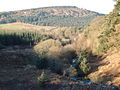
 Spa Well burn - geograph.org.uk - 379341.jpg 640 × 480; 113 KB
-
 Spa Well burn - geograph.org.uk - 379367.jpg 480 × 640; 86 KB
-

-
 The Clints of Dromore - geograph.org.uk - 219210.jpg 600 × 400; 95 KB
-
 The Devil's Stone - geograph.org.uk - 1393527.jpg 640 × 480; 303 KB
-
 The Quarterly journal of the Geological Society of London (12683199255).jpg 1,203 × 2,106; 590 KB
-
 The Shore at Arbigland - geograph.org.uk - 1393560.jpg 640 × 473; 289 KB
-
 The Thirl Stane - geograph.org.uk - 1393459.jpg 480 × 640; 317 KB
-
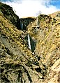
 Waterfall near Dob's Linn - geograph.org.uk - 38488.jpg 360 × 480; 17 KB
-
 Allwhannie Knowes - geograph.org.uk - 512957.jpg 480 × 640; 64 KB
-
 Birkie Cleuch - geograph.org.uk - 662524.jpg 638 × 464; 134 KB


.jpg)


