Category:February 2008 Ireland photographs
Jump to navigation
Jump to search
Countries of Europe: Armenia‡ · Austria · Belarus · Belgium · Bosnia and Herzegovina · Bulgaria · Croatia · Cyprus‡ · Czech Republic · Denmark · Estonia · Finland · France‡ · Georgia‡ · Germany · Greece · Hungary · Iceland · Republic of Ireland · Italy · Latvia · Lithuania · Luxembourg · Malta · Montenegro · Netherlands‡ · North Macedonia · Norway · Poland · Portugal‡ · Romania · Russia‡ · Serbia · Slovakia · Slovenia · Spain‡ · Sweden · Switzerland · Turkey‡ · Ukraine · United Kingdom · Vatican City
Specific status: Gibraltar · Isle of Man · Jersey
‡: partly located in Europe
Specific status: Gibraltar · Isle of Man · Jersey
‡: partly located in Europe
English: Images taken in Ireland during this month of 2008 (not the date of the upload). With CatScan, this allows one to browse any Ireland-related category by year or month. Images should be placed directly in this category, not in subcategories. Note: Images from 2008 should be also added into the appropriate province, territory or city category of Category:2008 photographs of Ireland.
| Jan | Feb | Mar | Apr | May | Jun | Jul | Aug | Sep | Oct | Nov | Dec | ||
| ← | 61 | 129 | 107 | 117 | 406 | 98 | 328 | 929 | 120 | 127 | 55 | 92 | → |
|---|
Subcategories
This category has only the following subcategory.
Media in category "February 2008 Ireland photographs"
The following 128 files are in this category, out of 128 total.
-
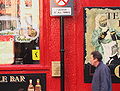 Temple Bar, Dublin.jpg 2,288 × 1,728; 974 KB
-
 Temple Bar Dublin Ireland.JPG 2,592 × 1,944; 2.18 MB
-

-
 Plaque for the Spire, O'Connell Street - geograph.org.uk - 714048.jpg 554 × 582; 449 KB
-
 Street lighting, Dublin - geograph.org.uk - 705376.jpg 480 × 640; 127 KB
-
 The Church, Mary Street - geograph.org.uk - 714071.jpg 438 × 640; 100 KB
-
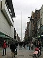 The Spire, from Mary Street - geograph.org.uk - 705258.jpg 480 × 640; 86 KB
-
 O'Neills, Suffolk Street - geograph.org.uk - 714059.jpg 480 × 640; 154 KB
-
 Bus Station, Dublin - geograph.org.uk - 704878.jpg 640 × 480; 51 KB
-
 Central bus station, Dublin - geograph.org.uk - 704378.jpg 640 × 490; 53 KB
-
 Connolly Station, Dublin - geograph.org.uk - 704868.jpg 480 × 640; 78 KB
-
 Lecky Statue, Trinity College - geograph.org.uk - 705512.jpg 480 × 640; 66 KB
-

-
 Mountain stream at Ballinguile - geograph.org.uk - 708658.jpg 640 × 480; 84 KB
-
 Stream flowing past Ballinguile - geograph.org.uk - 708659.jpg 640 × 480; 100 KB
-
 Abbey of St. Peter - Paul, Clones. - geograph.org.uk - 692349.jpg 640 × 480; 97 KB
-
 Alt Lower Townland - geograph.org.uk - 690077.jpg 640 × 479; 97 KB
-

-
 Annagh Hill from Knockbrack - geograph.org.uk - 705928.jpg 480 × 640; 117 KB
-
 Annagh viewed from Tombay - geograph.org.uk - 705922.jpg 640 × 480; 98 KB
-
 Arable land at Creagh Lower - geograph.org.uk - 704543.jpg 640 × 480; 94 KB
-
 Ardnaglass Townland - geograph.org.uk - 689280.jpg 640 × 479; 70 KB
-
 Arklow Library - geograph.org.uk - 692209.jpg 480 × 640; 45 KB
-
 Arklow Post Office. - geograph.org.uk - 692201.jpg 640 × 480; 69 KB
-
 Athlone Weir - geograph.org.uk - 725586.jpg 640 × 480; 90 KB
-
 Ballymacavany Townland - geograph.org.uk - 699881.jpg 640 × 479; 63 KB
-
 Bann River and Annagh Hill - geograph.org.uk - 705886.jpg 640 × 480; 119 KB
-
 Beech row at Broghan - geograph.org.uk - 731086.jpg 640 × 480; 113 KB
-
 Beech trees at Corballis - geograph.org.uk - 680031.jpg 480 × 640; 159 KB
-
 Beeches and sheep - geograph.org.uk - 714116.jpg 640 × 480; 96 KB
-
 Beeches at Annagh Middle - geograph.org.uk - 705903.jpg 640 × 437; 91 KB
-
 Beef pasture at Knockananna - geograph.org.uk - 708634.jpg 640 × 480; 81 KB
-
 Blackwater stream - geograph.org.uk - 705930.jpg 640 × 480; 92 KB
-
 Butt-railway-bridge.JPG 2,200 × 1,900; 323 KB
-
 Canal Bridge - geograph.org.uk - 708174.jpg 640 × 427; 85 KB
-
 Canal Bridge - geograph.org.uk - 708181.jpg 640 × 427; 75 KB
-
 Cappamore4566.jpg 3,858 × 1,843; 863 KB
-
 Castlefin, County Donegal.jpg 640 × 295; 35 KB
-
 Castletown 4444.JPG 3,888 × 2,592; 2.42 MB
-
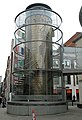
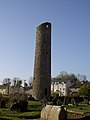 Clones Round Tower - geograph.org.uk - 692357.jpg 480 × 640; 55 KB
-
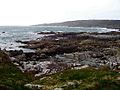 Connemara dogs bay3.jpg 554 × 416; 60 KB
-
 Connolly Station, Dublin - geograph.org.uk - 704871.jpg 640 × 480; 81 KB
-
 Coolalaw church - geograph.org.uk - 708057.jpg 640 × 480; 68 KB
-
 Countryside west of Ballylarkin - geograph.org.uk - 705817.jpg 640 × 480; 85 KB
-
 Current Lighthouse, Wicklow Head - geograph.org.uk - 692447.jpg 480 × 640; 44 KB
-
 Dublin Airport - geograph.org.uk - 705538.jpg 640 × 480; 76 KB
-
 DublinAirportSign0.jpg 640 × 480; 60 KB
-
 Dunlavin Courthouse - geograph.org.uk - 713914.jpg 640 × 480; 48 KB
-
 Dunlavin Fire Station - geograph.org.uk - 713974.jpg 640 × 480; 87 KB
-
 DunlavinRoad.JPG 3,740 × 1,873; 1.14 MB
-
 Falcarraghcrossroads.JPG 3,072 × 2,304; 1.8 MB
-
 Farm at Annagh Hill - geograph.org.uk - 705938.jpg 640 × 350; 65 KB
-
 Farm at Toberduff - geograph.org.uk - 705755.jpg 640 × 480; 78 KB
-
 Filling station near Ballycoolen - geograph.org.uk - 731046.jpg 640 × 480; 63 KB
-
 Gahan's Service Station and Store - geograph.org.uk - 703925.jpg 640 × 378; 52 KB
-
 Garda House, Dunlavin - geograph.org.uk - 713963.jpg 640 × 480; 67 KB
-
 Ha'penny Bridge over the Liffey - geograph.org.uk - 704890.jpg 640 × 480; 74 KB
-
 High Cross, Clones - geograph.org.uk - 692330.jpg 480 × 640; 74 KB
-
 Inside a polling station (3974438892).jpg 3,088 × 2,320; 2.35 MB
-
 Inside a polling station (3974439338).jpg 3,088 × 2,320; 2.41 MB
-
 Jacob's pub, Knockananna - geograph.org.uk - 708651.jpg 640 × 480; 62 KB
-

-
 Kilmurry pasture - geograph.org.uk - 705326.jpg 640 × 480; 96 KB
-
 Knockananna main street - geograph.org.uk - 708649.jpg 640 × 480; 83 KB
-
 Knockananna medical centre - geograph.org.uk - 708648.jpg 640 × 480; 66 KB
-
 Knockeyon4401c.jpg 3,884 × 1,954; 1.33 MB
-
 Loughultan Townland - geograph.org.uk - 699931.jpg 640 × 479; 57 KB
-
 Loughultan Townland - geograph.org.uk - 699933.jpg 640 × 479; 71 KB
-
 Loughultan Townland - geograph.org.uk - 699939.jpg 640 × 479; 63 KB
-
 Magheraboy Glebe - geograph.org.uk - 681373.jpg 640 × 296; 24 KB
-
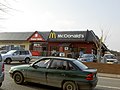 McDonalds, Arklow. - geograph.org.uk - 692187.jpg 640 × 480; 64 KB
-
 Meadows be the Bann - geograph.org.uk - 704220.jpg 640 × 479; 83 KB
-
 Monaseed - geograph.org.uk - 705924.jpg 640 × 480; 72 KB
-
 MultyfarnhamAbbey4394c.jpg 3,622 × 2,089; 2.06 MB
-
 N21near Tralee4600.jpg 3,813 × 2,497; 1.32 MB
-
 N21nearTralee4600.jpg 3,813 × 2,497; 1.29 MB
-
 N4road4416a.jpg 3,238 × 2,321; 1.76 MB
-
 Oola4557.jpg 3,888 × 2,592; 1.78 MB
-
 Pasture land at Ballyconlore - geograph.org.uk - 705853.jpg 640 × 480; 99 KB
-
 R390Dysert4434.jpg 3,888 × 2,592; 3.05 MB
-
 R391Westmeath.jpg 3,888 × 2,592; 1.71 MB
-
 Rainbow over the Liffey - geograph.org.uk - 705446.jpg 480 × 640; 48 KB
-
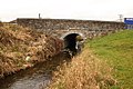 Renovated bridge - geograph.org.uk - 707772.jpg 640 × 427; 96 KB
-
 River Avoca, near Arklow - geograph.org.uk - 692227.jpg 640 × 480; 53 KB
-
 River Liffey - geograph.org.uk - 729213.jpg 640 × 480; 97 KB
-
 River Liffey - view upstream - geograph.org.uk - 714031.jpg 640 × 480; 75 KB
-
 River Walk. - geograph.org.uk - 692235.jpg 480 × 640; 99 KB
-
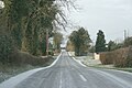
 Road at Ballymacavany - geograph.org.uk - 699880.jpg 640 × 479; 60 KB
-
 Road Bridge - geograph.org.uk - 707757.jpg 640 × 427; 57 KB
-
 Row of beeches at Aughullen - geograph.org.uk - 705849.jpg 640 × 480; 144 KB
-
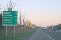
 Service station north of Gorey - geograph.org.uk - 705276.jpg 640 × 480; 76 KB
-
 Skelpy Townland - geograph.org.uk - 689159.jpg 640 × 479; 55 KB
-
 Slaney bridges at Enniscorthy - geograph.org.uk - 703954.jpg 640 × 480; 93 KB
-

-
 St. Pius X Church, Templeogue.jpg 3,888 × 2,592; 1.2 MB
-
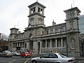
 St.Peters and Pauls.JPG 640 × 480; 41 KB
-
 Stream near Knockananna - geograph.org.uk - 708623.jpg 640 × 480; 115 KB
-
 Stubble field - geograph.org.uk - 705852.jpg 640 × 480; 143 KB
-
 Sugarloaf from Snugborough - geograph.org.uk - 713747.jpg 640 × 480; 84 KB
-
 The Coolgreany Inn - geograph.org.uk - 705813 (cropped).jpg 299 × 225; 21 KB
-
 The Coolgreany Inn - geograph.org.uk - 705813.jpg 640 × 480; 65 KB
-
 The Front Lighthouse, Wicklow Head. - geograph.org.uk - 692441.jpg 480 × 640; 45 KB
-
 The Liffey and Ballysmuttan Bridge - geograph.org.uk - 730941.jpg 640 × 480; 113 KB
-
 The Liffey, Dublin - geograph.org.uk - 705465.jpg 640 × 480; 77 KB
-

-
 The Park View - geograph.org.uk - 708050.jpg 640 × 323; 44 KB
-
 The Rear Lighthouse, Wicklow Head - geograph.org.uk - 692427.jpg 480 × 640; 52 KB
-
 The River Bann - geograph.org.uk - 704205.jpg 640 × 480; 111 KB
-
 The Silver Tankard Bar and Restaurant - geograph.org.uk - 704752.jpg 640 × 480; 120 KB
-
 Tievemagenta Townland - geograph.org.uk - 698822.jpg 640 × 479; 58 KB
-
 Tievemagenta Townland - geograph.org.uk - 698825.jpg 640 × 479; 56 KB
-
 Tievemagenta Townland - geograph.org.uk - 698845.jpg 640 × 479; 81 KB
-
 Tievemagenta Townland - geograph.org.uk - 698850.jpg 640 × 479; 64 KB
-
 Traffic island, Amiens Street - geograph.org.uk - 704882.jpg 640 × 480; 95 KB
-
 Universal Links For Human Rights (6286778913).jpg 3,056 × 4,592; 17.55 MB
-
 UniversalLinksOfHumanRights.jpg 480 × 640; 154 KB
-
 Unploughed land - geograph.org.uk - 703714.jpg 640 × 480; 96 KB
-
 Unusual entrance to unusual house - geograph.org.uk - 689284.jpg 640 × 281; 33 KB
-
 Unusual house at Ardnaglass - geograph.org.uk - 689289.jpg 479 × 640; 103 KB
-
 Vantage point for Enniscorthy - geograph.org.uk - 703939.jpg 640 × 480; 114 KB
-
 View north of Knockananna - geograph.org.uk - 708654.jpg 640 × 359; 59 KB
-
 View west to Ballyloughlin - geograph.org.uk - 705926.jpg 640 × 480; 87 KB
-
 Wicklow Town - geograph.org.uk - 692370 (cropped).jpg 640 × 216; 49 KB
-

-
 Window dressing, Mary Street, Dublin - geograph.org.uk - 704582.jpg 640 × 480; 90 KB
-
 YearsApart.jpg 3,888 × 2,592; 5.47 MB
-
 Road at Calhame - geograph.org.uk - 690071.jpg 640 × 479; 78 KB
-
 Road at Skelpy - geograph.org.uk - 689161.jpg 640 × 479; 79 KB


.jpg)
.jpg)


.jpg)


.jpg)


_-_geograph.org.uk_-_705917.jpg)


.jpg)