Category:Election maps of the United Kingdom
Jump to navigation
Jump to search
Countries of Europe: Albania · Andorra · Armenia‡ · Austria · Azerbaijan‡ · Belarus · Belgium · Bosnia and Herzegovina · Bulgaria · Croatia · Cyprus‡ · Czech Republic · Denmark · Estonia · Finland · France‡ · Georgia‡ · Germany · Greece · Hungary · Iceland · Republic of Ireland · Italy · Kazakhstan‡ · Latvia · Liechtenstein · Lithuania · Luxembourg · Malta · Moldova · Montenegro · Netherlands‡ · North Macedonia · Norway · Poland · Portugal‡ · Romania · Russia‡ · San Marino · Serbia · Slovakia · Slovenia · Spain‡ · Sweden · Switzerland · Turkey‡ · Ukraine · United Kingdom
Specific status: Faroe Islands · Gibraltar · Isle of Man · Jersey – Limited recognition: Kosovo · Northern Cyprus‡
‡: partly located in Europe
Specific status: Faroe Islands · Gibraltar · Isle of Man · Jersey – Limited recognition: Kosovo · Northern Cyprus‡
‡: partly located in Europe
Wikimedia category | |||||
| Upload media | |||||
| Instance of | |||||
|---|---|---|---|---|---|
| Category combines topics | |||||
| |||||
Subcategories
This category has the following 11 subcategories, out of 11 total.
E
U
Media in category "Election maps of the United Kingdom"
The following 194 files are in this category, out of 194 total.
-
 1784 British General Election.svg 10,865 × 13,090; 1.91 MB
-
 1784 General Election map.png 1,548 × 2,620; 245 KB
-
 1852 UK general election map.svg 900 × 1,231; 6.19 MB
-
 1857 UK general election map.svg 900 × 1,231; 6.19 MB
-
 1859 UK general election map.svg 900 × 1,231; 6.18 MB
-
 1865 UK general election map.svg 900 × 1,231; 6.25 MB
-
 1918 UK general election map.svg 1,200 × 1,231; 6.22 MB
-
 1918 UK General Election Results.png 2,700 × 2,958; 381 KB
-
 1922 UK general election map.svg 829 × 1,231; 5.03 MB
-
 1922 UK General Election Results.png 2,200 × 2,958; 307 KB
-
 1923 election wiki.png 1,860 × 2,960; 173 KB
-
 1923 UK general election map.svg 829 × 1,231; 5.03 MB
-
 1923 UK General Election Results.png 2,200 × 2,958; 309 KB
-
 1924 UK general election map.svg 829 × 1,231; 5.03 MB
-
 1924 UK General Election Results.png 2,200 × 2,958; 299 KB
-
 1929 UK general election map.svg 829 × 1,231; 5.03 MB
-
 1929 UK General Election Results.png 2,200 × 2,958; 305 KB
-
 1931 UK general election map.svg 829 × 1,231; 5.03 MB
-
 1931 UK General Election Results.png 2,200 × 2,958; 301 KB
-
 1935 UK general election map.svg 829 × 1,231; 5.03 MB
-
 1935 UK General Election Results.png 2,200 × 2,958; 304 KB
-
 1945 UK general election map.svg 829 × 1,231; 4.64 MB
-
 1964 General Election results map.png 300 × 445; 72 KB
-
 1975 referendum results by nation.svg 1,062 × 1,964; 10.55 MB
-
 1979 United Kingdom EU Election.svg 544 × 630; 24.43 MB
-
 1983 United Kingdom General Election.svg 1,122 × 1,267; 10.03 MB
-
 1992 United Kingdom General Election.svg 1,122 × 1,267; 10.17 MB
-
 1997 UK General Election Constituencies.svg 512 × 680; 78 KB
-
 1997 UK general election, countries and regions.svg 512 × 640; 2.01 MB
-
 1997 Yorkshire Devolution Referendum.svg 1,425 × 1,212; 1.22 MB
-
 2001 UK General Election Constituencies Gains.svg 512 × 680; 77 KB
-
 2001 UK General Election Constituencies.svg 512 × 680; 78 KB
-
 2001 UK general election, countries and regions.svg 512 × 640; 2.01 MB
-
 2005 UK Election Respect results.svg 1,001 × 977; 1.1 MB
-
 2005 UK General Election Constituencies.svg 512 × 680; 75 KB
-
 2005 UK General Election Constituency Gains.svg 512 × 680; 74 KB
-
 2005 UK general election, countries and regions.svg 512 × 640; 2.03 MB
-
 2005UKElectionMap.svg 690 × 982; 509 KB
-
 2010 UK Election Respect results.svg 1,020 × 996; 7.77 MB
-
 2010 UK general election, countries and regions.svg 512 × 640; 2.03 MB
-
 2010UKElectionMap votes.svg 1,020 × 996; 7.77 MB
-
 2011 United Kingdom Alternative Vote referendum results by local voting area.svg 800 × 1,481; 1.24 MB
-

-

-

-

-
-

-
-

-
 2013 UK Local Elections - Ward and Council Control.svg 623 × 569; 7.82 MB
-
 2014 Euro Election UK.png 1,131 × 1,291; 27 KB
-
 2014 United Kingdom EU Election.svg 1,050 × 1,220; 6.91 MB
-
 2015 party vote share by constituency.png 4,951 × 5,014; 4.39 MB
-
 2015 UK general election map.png 1,440 × 1,024; 436 KB
-
 2015 UK general election, countries and regions.svg 512 × 640; 2.03 MB
-
 2015 UK General election, UKIP vote share by constituency.svg 512 × 426; 5.89 MB
-
 2015UKGeneralElectionMap.png 978 × 1,040; 514 KB
-
 2016 referendum results district.svg 1,062 × 1,964; 97.75 MB
-
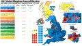
 2017 UK general election, countries and regions.svg 512 × 640; 2.01 MB
-
 2017 UK General Election.svg 1,321 × 1,254; 27.29 MB
-
 2017 UK local elections - Ward and Council Control.svg 967 × 821; 13.23 MB
-

-
 2019 General Election Results.png 5,080 × 4,980; 3.54 MB
-
 2019 uk election with MMP.svg 620 × 900; 929 KB
-
 2019 UK General Election Using My Electoral Regions.png 1,399 × 1,793; 565 KB
-
 2019 UK General Election Winner%.svg 512 × 426; 5.99 MB
-
 2019 UK general election, countries and regions.svg 512 × 640; 2.02 MB
-
 2019 UK General Election.svg 1,321 × 1,254; 27.3 MB
-
 2019 UK Local Elections by Ward.svg 589 × 730; 13.23 MB
-
 2019 United Kingdom EU Election.svg 1,050 × 1,220; 6.78 MB
-
 2019LDS GE.svg 1,248 × 1,039; 7.64 MB
-
 2022 UK Local Elections Control.svg 512 × 768; 2.5 MB
-
 2023 UK Constituencies Blank Map.svg 1,118 × 1,266; 11.3 MB
-
 2023 UK Local Elections Control.svg 807 × 813; 2.79 MB
-
 2023 UK Local Elections.svg 807 × 813; 2.7 MB
-
 2023 United Kingdom local elections, control.svg 512 × 768; 2.61 MB
-

-
 December 1910 United Kingdom General Election.svg 1,215 × 1,281; 12.67 MB
-
 Dumfries and galloway 2022.png 991 × 571; 107 KB
-
 ElectionUK.png 5,080 × 4,980; 3.2 MB
-
 England Summary (42140583855).png 4,380 × 2,476; 527 KB
-
 English council election 2018.svg 1,108 × 1,345; 509 KB
-
 EU Ref Leave Remain RedBlue 52Split.png 5,080 × 4,980; 3.52 MB
-
 European Parliament election, 2004 (United Kingdom).svg 984 × 1,838; 10.5 MB
-
 European Parliament election, 2009 (United Kingdom).svg 822 × 1,536; 11.76 MB
-
 European Parliament election, 2014 (United Kingdom).svg 2,142 × 4,000; 12.12 MB
-
 European Parliament election, 2019 (United Kingdom) area results.svg 728 × 1,254; 3.02 MB
-
 January 1910 United Kingdom General Election.svg 1,215 × 1,281; 12.65 MB
-
 Labour gains 2019.png 5,080 × 4,980; 3.6 MB
-
 Labour Leadership Election 2010 Results by Constituency.png 2,588 × 1,953; 1.04 MB
-
 Map of the results of the United Kingdom local elections 2009.png 2,400 × 2,700; 228 KB
-
 New2005UKElectionMap.svg 690 × 982; 509 KB
-
 Next UK General Election.svg 1,321 × 1,254; 19.32 MB
-
 Noah-05-map.png 800 × 1,139; 343 KB
-
 Noah-08-map.png 800 × 1,139; 339 KB
-
 Results for 1975 UK referendum on EEC by county.svg 1,062 × 1,964; 20.89 MB
-
 Results of the 2019 General Election in the UK v2.png 5,080 × 4,980; 3.72 MB
-
 Results of the 2019 General Election in the UK.png 5,080 × 4,980; 3.71 MB
-
 Size of electorate in each United Kingdom house of commons constituency 2023.png 9,600 × 7,200; 2.16 MB
-
 South Holland District Council wards.svg 2,191 × 1,549; 673 KB
-
 Test GB Wahlkreise.png 306 × 621; 64 KB
-
 Tyron West pre (29171340638).png 1,748 × 1,996; 208 KB
-
 Tyron West SF hold (42140588345).png 1,748 × 1,996; 202 KB
-
 UK 2019 Election.svg 512 × 288; 2.37 MB
-
 UK countries and dependencies by political party.svg 721 × 1,356; 2.54 MB
-
 UK election, 1979.svg 1,172 × 1,906; 825 KB
-
 UK election, Oct 1974 (low res).png 351 × 516; 298 KB
-
 UK election, Oct 1974.svg 1,159 × 1,704; 779 KB
-
 UK European Parliament constituency 2021.svg 512 × 937; 96 KB
-
 UK European Parliament constituency.svg 641 × 1,173; 259 KB
-
 UK General Election 1997.svg 690 × 982; 2.62 MB
-
 UK General Election, 1918.png 1,530 × 1,703; 143 KB
-
 UK General Election, 1922.png 429 × 599; 147 KB
-
 UK General Election, 1929.png 1,281 × 1,708; 118 KB
-
 UK General Election, 1931.png 1,273 × 1,784; 116 KB
-
 UK General Election, 1935.png 1,300 × 1,770; 118 KB
-
 UK General Election, 1945.png 2,112 × 2,960; 277 KB
-
 UK General Election, 1950.svg 829 × 1,231; 1.55 MB
-
 UK General Election, 1951.svg 829 × 1,231; 1.55 MB
-
 UK General Election, 1955.svg 829 × 1,231; 1.63 MB
-
 UK General Election, 1959.svg 829 × 1,231; 1.61 MB
-
 UK General Election, 1964.svg 829 × 1,231; 1.63 MB
-
 UK General Election, 1966.svg 829 × 1,231; 1.63 MB
-
 UK General Election, 1970.svg 829 × 1,231; 1.63 MB
-
 UK General Election, 1979.svg 829 × 1,231; 2.78 MB
-
 UK General Election, 1983.svg 635 × 1,002; 761 KB
-
 UK General Election, 1987.svg 635 × 1,002; 760 KB
-
 UK General Election, 1997.svg 690 × 982; 2.62 MB
-
 UK General Election, 2001.svg 690 × 982; 2.53 MB
-
 UK General Election, February 1974.svg 829 × 1,231; 2.78 MB
-
 UK General Election, October 1974.svg 829 × 1,231; 2.78 MB
-
 UK Local Authorities 2023.svg 512 × 768; 2.6 MB
-
 UK local authorities, largest party post 2023 elections.svg 512 × 768; 2.7 MB
-
 United Kingdom 1955 Alternate Map.png 1,024 × 1,521; 395 KB
-
 United Kingdom AV Referendum 2011 Regional Results.svg 886 × 1,369; 959 KB
-
 United Kingdom AV referendum area results.svg 871 × 1,289; 4.45 MB
-
 United Kingdom EU referendum 2016 area results (3).svg 871 × 1,289; 5.04 MB
-
 United Kingdom EU referendum 2016 area results 2-tone.svg 871 × 1,289; 4.66 MB
-
 United Kingdom EU referendum 2016 area results 2.svg 871 × 1,289; 5.01 MB
-
 United Kingdom EU referendum 2016 area results BrB.svg 871 × 1,289; 4.63 MB
-
 United Kingdom EU referendum 2016 area results-en.svg 871 × 1,289; 4.55 MB
-
 United Kingdom EU referendum 2016 voting regions results.svg 886 × 1,369; 2.67 MB
-
 United Kingdom general election 1830.svg 1,164 × 1,209; 4.88 MB
-
 United Kingdom general election 1831.svg 1,164 × 1,209; 4.98 MB
-
 United Kingdom general election 1832.svg 1,166 × 1,211; 7.61 MB
-
 United Kingdom general election 1835.svg 1,166 × 1,213; 8.53 MB
-
 United Kingdom general election 1837.svg 1,166 × 1,213; 9.02 MB
-
 United Kingdom general election 1841.svg 1,166 × 1,213; 9.21 MB
-
 United Kingdom general election 1868.svg 1,166 × 1,211; 7.43 MB
-
 United Kingdom general election 1874.svg 1,166 × 1,211; 7.46 MB
-
 United Kingdom general election 1880.svg 1,166 × 1,211; 7.47 MB
-
 United Kingdom general election 1885.svg 1,166 × 1,211; 8.06 MB
-
 United Kingdom general election 1886.svg 1,166 × 1,211; 8.09 MB
-
 United Kingdom general election 1892.svg 1,166 × 1,211; 8.09 MB
-
 United Kingdom general election 1895.svg 1,166 × 1,211; 8.08 MB
-
 United Kingdom general election 1900.svg 1,166 × 1,211; 8.09 MB
-
 United Kingdom general election 1906.svg 1,166 × 1,211; 8.08 MB
-
 United Kingdom general election 1910 December.svg 1,166 × 1,211; 8.17 MB
-
 United Kingdom general election 1910 January.svg 1,166 × 1,211; 8.17 MB
-
 United Kingdom local elections 2019 map.png 1,296 × 1,356; 385 KB
-
 United Kingdom local elections, 1977.svg 289 × 540; 4.28 MB
-
 United Kingdom local elections, 1981.svg 289 × 540; 4.28 MB
-
 United Kingdom local elections, 1985.svg 289 × 540; 4.41 MB
-
 United Kingdom local elections, 1993.svg 289 × 540; 4.41 MB
-
 United Kingdom local elections, 1995.svg 321 × 600; 9.59 MB
-
 United Kingdom local elections, 1997.svg 289 × 540; 3.04 MB
-
 United Kingdom local elections, 2000.svg 321 × 600; 8.57 MB
-
 United Kingdom local elections, 2001.svg 289 × 540; 3.04 MB
-
 United Kingdom local elections, 2002.svg 321 × 600; 8.58 MB
-
 United Kingdom local elections, 2003.svg 321 × 600; 8.61 MB
-
 United Kingdom local elections, 2004.svg 321 × 600; 8.62 MB
-
 United Kingdom local elections, 2005.svg 289 × 540; 3.04 MB
-
 United Kingdom local elections, 2006.svg 321 × 600; 8.62 MB
-
 United Kingdom local elections, 2007.svg 321 × 600; 8.66 MB
-
 United Kingdom local elections, 2008.svg 247 × 461; 7.81 MB
-
 United Kingdom local elections, 2017 - Control Change.svg 142 × 263; 4.07 MB
-
 United Kingdom local elections, 2017 - Previous Control.svg 142 × 263; 4.1 MB
-
 Urmston 1958.png 1,067 × 791; 70 KB
-
 Urmston 1959.png 1,176 × 820; 65 KB
-
 Urmston 1960.png 1,095 × 807; 67 KB
-
 Urmston 1961.png 1,132 × 796; 67 KB
-
 Urmston 1962.png 1,057 × 797; 66 KB
-
 Urmston 1963.png 1,063 × 805; 66 KB
-
 Urmston 1964.png 1,112 × 812; 67 KB
-
 Urmston 1965.png 1,101 × 797; 66 KB
-
 Urmston 1966.png 1,111 × 811; 66 KB
-
 Urmston 1967.png 1,105 × 798; 67 KB
-
 Urmston 1968.png 1,122 × 808; 66 KB
-
 Urmston 1969.png 1,111 × 810; 67 KB
-
 Urmston 1970.png 1,112 × 811; 67 KB
-
 Urmston 1971.png 1,137 × 811; 67 KB
-
 Urmston 1972.png 1,112 × 792; 67 KB
-
 Vote share percentage for individual constituencies..png 4,928 × 4,952; 4.36 MB


.png)


.svg)
.svg)
.svg)
_area_results.svg)


.png)
.png)


.png)


.svg)


