Category:December 2007 in North Yorkshire
Jump to navigation
Jump to search
Deutsch: Bilder, die im Dezember 2007 in North Yorkshire aufgenommen worden sind. Bitte beachten Sie, dass dies weder das Datum des Uploads noch das Datum des Scannens eines Fotos ist.
English: Images/pictures taken in North Yorkshire during December 2007. Note this is not the date of the upload, nor the date a photo was scanned.
Español: Fotografías o imágenes tomadas en North Yorkshire durante diciembre 2007. No es la fecha de subida ni escaneo, sino la fecha en que las fotografías o imágenes se crearon.
Esperanto: Bildoj faritaj en North Yorkshire en decembro 2007. Tio ne estas la dato, kiam la bildoj estis alŝutitaj aŭ skanitaj.
Français : Photographies ou images prises en North Yorkshire durant décembre 2007. Ce n'est pas la date du téléchargement ou du scan.
Galego: Fotografías ou imaxes tomadas en North Yorkshire durante decembro 2007. Non é a data de subida nin escaneamento, senón a data na que se crearon as fotografías ou imaxes.
Italiano: Fotografie o immagini scattate a North Yorkshire nel dicembre 2007. Nota bene: la data non si riferisce né a quella di upload né a quella in cui la foto è stata digitalizzata.
Norsk bokmål: Bilder tatt i North Yorkshire i løpet av desember 2007. Merk at dette ikke er datoen for opplasting, eller når et bilde har blitt skannet.
Norsk nynorsk: Bilete teke i North Yorkshire i løpet av desember 2007. Merk at dette ikkje er datoen for opplasting, eller når eit bilete har vorte skanna.
Русский: Изображения, сделанные в North Yorkshire в течение декабрь 2007 (не дата загрузки изображения).
Українська: Зображення, зроблені в North Yorkshire протягом грудень 2007. Зауважте, що це не дата завантаження чи дата сканування фотографії.
| December 2006 | ← | December 2007 | → | December 2008 | |||||||
| Jan | Feb | Mar | Apr | May | Jun | Jul | Aug | Sep | Oct | Nov | Dec |
| 95 | 83 | 153 | 268 | 201 | 135 | 221 | 318 | 135 | 112 | 152 | 138 |
|---|---|---|---|---|---|---|---|---|---|---|---|
Subcategories
This category has only the following subcategory.
Y
Media in category "December 2007 in North Yorkshire"
The following 137 files are in this category, out of 137 total.
-
 "The Vic" at Kirkby Malham - geograph.org.uk - 638504.jpg 640 × 480; 387 KB
-
 'Colvend' Grassington - geograph.org.uk - 637338.jpg 640 × 480; 109 KB
-
 Frosty Logs in Coverdale - geograph.org.uk - 635441.jpg 443 × 640; 103 KB
-
 Hellifield (2123082193).jpg 1,024 × 768; 494 KB
-
 Hag Dyke - geograph.org.uk - 637577.jpg 640 × 480; 37 KB
-

-
 AA Box 442 - geograph.org.uk - 639035.jpg 480 × 640; 95 KB
-
 Abandoned Stable Block - geograph.org.uk - 625777.jpg 640 × 427; 69 KB
-
 An ancient beech - geograph.org.uk - 642172.jpg 480 × 640; 126 KB
-
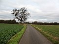
 Arable field near Scruton - geograph.org.uk - 636546.jpg 640 × 480; 51 KB
-
 Arable land, Forest of Galtres - geograph.org.uk - 628783.jpg 640 × 480; 68 KB
-
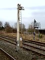
 Barlby signal box - geograph.org.uk - 644777.jpg 640 × 427; 87 KB
-
 Betty's Tea Shop - geograph.org.uk - 626500.jpg 640 × 427; 67 KB
-
 Bilton Working Men's Club - geograph.org.uk - 632623.jpg 640 × 480; 84 KB
-
 Bishop Monkton CE Primary School - geograph.org.uk - 630143.jpg 640 × 480; 72 KB
-
 Central Arcade - geograph.org.uk - 626506 (cropped).jpg 427 × 427; 144 KB
-
 Central Arcade - geograph.org.uk - 626506.jpg 427 × 640; 234 KB
-

-
 Cod Beck Reservoir in the Rain - geograph.org.uk - 626507.jpg 640 × 427; 66 KB
-
 Cowbar Nab - geograph.org.uk - 699972.jpg 640 × 430; 61 KB
-
 Dry Stone Wall above Peart Crags - geograph.org.uk - 629085.jpg 640 × 480; 106 KB
-

-
 Drystone Wall on Horsehouse Moor (2) - geograph.org.uk - 644794.jpg 488 × 640; 332 KB
-
 Drystone Wall on Horsehouse Moor (3) - geograph.org.uk - 644800.jpg 427 × 640; 263 KB
-
 Drystone Wall on Horsehouse Moor - geograph.org.uk - 644791.jpg 640 × 330; 229 KB
-
 Drystone Wall on North Tarn Hill - geograph.org.uk - 645233.jpg 640 × 385; 264 KB
-
 Duchy Estate villas - geograph.org.uk - 631843.jpg 640 × 445; 77 KB
-
 Easingwold Library - geograph.org.uk - 629022.jpg 640 × 480; 136 KB
-
 Easingwold Post Office - geograph.org.uk - 629016.jpg 480 × 640; 88 KB
-
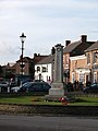 Easingwold War Memorial - geograph.org.uk - 628964.jpg 480 × 640; 66 KB
-
 Farm road, Ripon Parks - geograph.org.uk - 643840.jpg 640 × 480; 69 KB
-
 Fields North of Eastby - geograph.org.uk - 636867.jpg 640 × 480; 58 KB
-
 Ford, Glaisdale Beck - geograph.org.uk - 633685.jpg 640 × 427; 86 KB
-
 Foreshore at Robin Hood's Bay - geograph.org.uk - 633461.jpg 640 × 480; 89 KB
-
 Forest Track Through Greenhow Plantation - geograph.org.uk - 645550.jpg 640 × 427; 283 KB
-

-

-

-

-

-

-

-

-

-

-

-

-

-

-

-
 Gayle Mill - geograph.org.uk - 1711981.jpg 1,280 × 853; 437 KB
-
 Hambleton 005.jpg 640 × 480; 77 KB
-
 Harrogate Fire Station - geograph.org.uk - 632641.jpg 640 × 480; 95 KB
-
 St Lukes Court - geograph.org.uk - 632600.jpg 480 × 640; 69 KB
-
 Hellifield (2123084591).jpg 1,200 × 1,600; 697 KB
-
 Hellifield (2123089025).jpg 1,200 × 1,600; 422 KB
-
 Hellifield (2123858164).jpg 1,600 × 1,200; 524 KB
-
 Hellifield (2123862800).jpg 768 × 1,024; 533 KB
-
 Hellifield (2123864338).jpg 1,200 × 1,600; 480 KB
-
 Hellifield (2123867132).jpg 1,200 × 1,600; 639 KB
-
 Hellifield railway station DI2.jpg 1,024 × 768; 420 KB
-
 Hollins seen across a field - geograph.org.uk - 700049.jpg 640 × 430; 53 KB
-
 Holy Trinity Church - geograph.org.uk - 643998.jpg 640 × 609; 84 KB
-
 Houses overlooking the Market Place. - geograph.org.uk - 628966.jpg 640 × 480; 80 KB
-
 Ingleby Incline (1) - geograph.org.uk - 642812.jpg 640 × 364; 201 KB
-
 Ingleby Incline (10) - geograph.org.uk - 643015.jpg 427 × 640; 266 KB
-
 Ingleby Incline (11) - geograph.org.uk - 643018.jpg 427 × 640; 259 KB
-
 Ingleby Incline (12) - geograph.org.uk - 643029.jpg 640 × 427; 256 KB
-
 Ingleby Incline (2) - geograph.org.uk - 642817.jpg 640 × 427; 269 KB
-
 Ingleby Incline (3) - geograph.org.uk - 642819.jpg 640 × 427; 278 KB
-
 Ingleby Incline (4) - geograph.org.uk - 642832.jpg 640 × 427; 221 KB
-
 Ingleby Incline (5) - geograph.org.uk - 643003.jpg 427 × 640; 296 KB
-
 Ingleby Incline (6) - geograph.org.uk - 643005.jpg 640 × 392; 251 KB
-
 Ingleby Incline (7) - geograph.org.uk - 643006.jpg 427 × 640; 301 KB
-
 Ingleby Incline (8) - geograph.org.uk - 643011.jpg 482 × 640; 304 KB
-
 Ingleby Incline (9) - geograph.org.uk - 643013.jpg 427 × 640; 297 KB
-
 Kildale Village.jpg 640 × 427; 77 KB
-
 Lineside Building, Old Mineral Railway - geograph.org.uk - 625037.jpg 640 × 427; 102 KB
-
 Little Lane Easingwold - geograph.org.uk - 628985.jpg 640 × 480; 93 KB
-
 Local shopping parade in Kings Road - geograph.org.uk - 632618.jpg 640 × 414; 67 KB
-
 Lone Sheep, The Park - geograph.org.uk - 640188.jpg 640 × 427; 88 KB
-
 Long Street Easingwold - geograph.org.uk - 628978.jpg 640 × 480; 93 KB
-

-
 Market Day in Easingwold. - geograph.org.uk - 628996.jpg 640 × 480; 121 KB
-
 Market Place - west side - geograph.org.uk - 629005.jpg 640 × 480; 79 KB
-
 Market stalls at Easingwold. - geograph.org.uk - 629012.jpg 640 × 480; 80 KB
-
 Masons Arms, Bishop Monkton - geograph.org.uk - 630147.jpg 640 × 444; 73 KB
-
 Mossy Logs at Malham Tarn - geograph.org.uk - 640430.jpg 639 × 386; 256 KB
-
 Mount Bridge - geograph.org.uk - 643434.jpg 640 × 480; 252 KB
-
 Mount Bridge and Mount Farm - geograph.org.uk - 643458.jpg 640 × 480; 227 KB
-
 North Bridge - geograph.org.uk - 640580.jpg 640 × 341; 61 KB
-
 Old cottages in Easingwold - geograph.org.uk - 628931.jpg 640 × 480; 104 KB
-
 Old Pier - geograph.org.uk - 700003.jpg 640 × 430; 85 KB
-
 Old Railway Station, Ripon - geograph.org.uk - 643795.jpg 640 × 480; 82 KB
-

-
 Peacocks store front, Captain Cook Square - geograph.org.uk - 648120.jpg 480 × 640; 128 KB
-
 Port Mulgrave - geograph.org.uk - 700004.jpg 640 × 430; 65 KB
-
 Remains of railway viaduct - geograph.org.uk - 699993.jpg 430 × 640; 74 KB
-
 River valley, Staithes - geograph.org.uk - 699995.jpg 640 × 430; 96 KB
-
 Ruins, Carrs Tillery - geograph.org.uk - 625028.jpg 640 × 427; 129 KB
-
 Sandsend railway station (geograph 3890752).jpg 3,872 × 2,592; 2.33 MB
-
 Seawall and Bay Hotel - geograph.org.uk - 665551.jpg 640 × 430; 63 KB
-
 Selby War Memorial Hospital - geograph.org.uk - 644725.jpg 640 × 480; 180 KB
-
 Settle railway station DI1.jpg 1,024 × 768; 504 KB
-
 Ship Inn, Port Mulgrave - geograph.org.uk - 700001.jpg 640 × 430; 75 KB
-
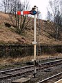
 Signal Box at the Whitehouse Crossing - geograph.org.uk - 627259.jpg 640 × 427; 78 KB
-
 Spring Street, Easingwold - geograph.org.uk - 628961.jpg 640 × 480; 61 KB
-
 St Wilfred's Catholic Church, Ripon.jpg 640 × 440; 83 KB
-
 Staithes breakwater and Cowbar Nab - geograph.org.uk - 699983.jpg 640 × 430; 63 KB
-
 Staithes Harbour - geograph.org.uk - 699980.jpg 640 × 430; 71 KB
-
 The Angel, Easingwold - geograph.org.uk - 628962.jpg 640 × 480; 82 KB
-
 The church on Hilton Road, Seamer - geograph.org.uk - 1639579.jpg 640 × 480; 129 KB
-
 The entrance to Burton Hall - geograph.org.uk - 644667.jpg 640 × 480; 59 KB
-
 The Falcon Inn, Arncliffe - geograph.org.uk - 636809.jpg 640 × 480; 109 KB
-
 The finest bus shelter in Yorkshire^ - geograph.org.uk - 637343.jpg 640 × 480; 114 KB
-
 The Gardener's Arms, Bilton - geograph.org.uk - 632645.jpg 640 × 480; 90 KB
-
 The George at Easingwold - geograph.org.uk - 628968.jpg 640 × 480; 88 KB
-
 The Lamb and Flag, Bishop Monkton - geograph.org.uk - 630162.jpg 640 × 416; 66 KB
-
 The Mount, Easingwold - geograph.org.uk - 628953.jpg 480 × 640; 97 KB
-
 The New Inn, Easingwold - geograph.org.uk - 628990.jpg 640 × 480; 61 KB
-
 The Three Coopers, Bedale - geograph.org.uk - 636616.jpg 480 × 640; 121 KB
-
 The Weir - geograph.org.uk - 642227.jpg 640 × 480; 84 KB
-
 The World of James Herriot - geograph.org.uk - 636931.jpg 640 × 405; 72 KB
-
 Uppleby, Easingwold - geograph.org.uk - 628940.jpg 640 × 480; 112 KB
-
 View over Staithes - geograph.org.uk - 699975.jpg 640 × 430; 75 KB
-
 Wave cut platform and cliff - geograph.org.uk - 699986.jpg 640 × 430; 90 KB
-
 Woodside Farm - geograph.org.uk - 629564.jpg 640 × 480; 51 KB
-
 YDNP information centre - geograph.org.uk - 637347.jpg 640 × 480; 98 KB
-
 Alley Leading to Mill Street - geograph.org.uk - 630830.jpg 427 × 640; 52 KB
-
 Boathouse on Malham Tarn - geograph.org.uk - 640427.jpg 634 × 328; 167 KB
-
 Catwick House Farm - geograph.org.uk - 633219.jpg 640 × 480; 107 KB
-
 Entrance to Mortar Hall Farm - geograph.org.uk - 633211.jpg 640 × 456; 102 KB
-
 Farmland south of Sneaton Thorpe Lane - geograph.org.uk - 633191.jpg 640 × 480; 101 KB
-
 Handsome Heifers - geograph.org.uk - 638677.jpg 640 × 480; 92 KB
-
 Highland Cattle (near Haw Lane) - geograph.org.uk - 632767.jpg 640 × 480; 103 KB
-
 Rigg Farm - geograph.org.uk - 633226.jpg 640 × 480; 134 KB
-
 Sneaton Thorpe Lane - geograph.org.uk - 633193.jpg 640 × 480; 114 KB


.jpg)


.jpg)


_-_geograph.org.uk_-_644794.jpg)
_-_geograph.org.uk_-_644800.jpg)


.jpg)
.jpg)
.jpg)
.jpg)
.jpg)
.jpg)


_-_geograph.org.uk_-_642812.jpg)
_-_geograph.org.uk_-_643015.jpg)
_-_geograph.org.uk_-_643018.jpg)
_-_geograph.org.uk_-_643029.jpg)
_-_geograph.org.uk_-_642817.jpg)
_-_geograph.org.uk_-_642819.jpg)
_-_geograph.org.uk_-_642832.jpg)
_-_geograph.org.uk_-_643003.jpg)
_-_geograph.org.uk_-_643005.jpg)
_-_geograph.org.uk_-_643006.jpg)
_-_geograph.org.uk_-_643011.jpg)
_-_geograph.org.uk_-_643013.jpg)


.jpg)


_-_geograph.org.uk_-_632767.jpg)

