Category:Cass Peak
Jump to navigation
Jump to search
hill in New Zealand  | |||||
| Upload media | |||||
| Instance of | |||||
|---|---|---|---|---|---|
| Named after | |||||
| Location | Christchurch City, Canterbury Region, New Zealand | ||||
| Mountain range | |||||
| Elevation above sea level |
| ||||
 | |||||
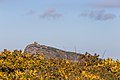
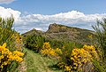
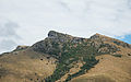
Cass Peak (Māori: Ō-Rongo-Mai) is a hill in the western Port Hills in Christchurch, New Zealand. Its most notable feature is a radar dome that was built on the peak in the late 1980s, which is used for aircraft positioning services.
Media in category "Cass Peak"
The following 16 files are in this category, out of 16 total.
-
 Cass Peak 211.JPG 5,472 × 3,648; 4.05 MB
-
 Cass Peak 213.JPG 5,472 × 3,648; 3.63 MB
-
 Cass Peak 214.JPG 5,472 × 3,648; 6.1 MB
-
 Cass Peak 217.JPG 5,472 × 3,648; 5.2 MB
-
 Cass Peak Scenic Reserve.jpg 2,203 × 1,652; 406 KB
-
 Cass Peak, Port Hills, New Zealand 01.jpg 5,472 × 3,648; 8.47 MB
-
 Crater Rim walkway 209.JPG 3,648 × 5,472; 6.34 MB
-
 Crater Rim walkway 210.JPG 3,648 × 5,472; 7.1 MB
-
 Crater Rim walkway 212.JPG 5,472 × 3,648; 4.87 MB
-
 Crater Rim walkway with Cass Peak, Canterbury, New Zealand.jpg 5,021 × 3,402; 13.81 MB
-
 Hills of Kennedys Bush Reserve 20100119.jpg 3,872 × 2,420; 2.66 MB
-
 Port Hills 230.JPG 5,472 × 3,648; 3.8 MB
-
 Port Hills 233.JPG 5,472 × 3,648; 4.32 MB
-
 Port Hills 234.JPG 5,472 × 3,648; 2.83 MB
-
 Summit Road & Kennedys Bush Scenic Reserve.jpg 2,203 × 1,652; 544 KB
-
 The Golf Ball - Cass Peak.jpg 800 × 600; 127 KB


