Category:Caistor St. Edmund
Jump to navigation
Jump to search
Norsk bokmål: Caistor St. Edmund er en landsby med omtrent 270 innbyggere som ligger ved elven Tas omtrent 8 km sørøst for Norwich i Norfolk i England
village and former civil parish in Norfolk, UK  | |||||
| Upload media | |||||
| Instance of |
| ||||
|---|---|---|---|---|---|
| Location | Caistor St Edmund and Bixley, South Norfolk, Norfolk, East of England, England | ||||
| Area |
| ||||
 | |||||
Subcategories
This category has the following 7 subcategories, out of 7 total.
C
- Caistor St. Edmund Chalk Pit (8 F)
E
- Environs of Caistor St. Edmund (20 F)
F
N
S
V
- Venta Icenorum (47 F)
Media in category "Caistor St. Edmund"
The following 58 files are in this category, out of 58 total.
-

-
 A big gap in the fence - geograph.org.uk - 1656985.jpg 640 × 480; 146 KB
-

-

-

-
 A hedge field boundary - geograph.org.uk - 1656944.jpg 640 × 459; 131 KB
-
 A shelterbelt of trees - geograph.org.uk - 1656726.jpg 640 × 480; 80 KB
-
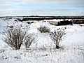
 A snowy field boundary - geograph.org.uk - 1656839.jpg 640 × 480; 118 KB
-
 A view from Boudica's Way - geograph.org.uk - 1772110.jpg 640 × 480; 102 KB
-
 Ancient willow tree - geograph.org.uk - 1352861.jpg 640 × 480; 153 KB
-
 Approaching Arminghall Wood - geograph.org.uk - 1656806.jpg 640 × 480; 106 KB
-

-

-

-
 Bare tree on field boundary - geograph.org.uk - 1656741.jpg 480 × 640; 194 KB
-
 Boudica's Way - a shady path - geograph.org.uk - 1378761.jpg 529 × 640; 186 KB
-
 Boudica's Way - a view - geograph.org.uk - 1378671.jpg 640 × 480; 111 KB
-
 Boudica's Way - skirting Arminghall Wood - geograph.org.uk - 1378752.jpg 640 × 480; 130 KB
-

-
 Boudica's Way in the snow - geograph.org.uk - 1656881.jpg 640 × 512; 121 KB
-
 Boudica's Way to Arminghall - geograph.org.uk - 1656941.jpg 640 × 520; 143 KB
-
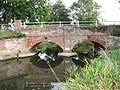 Bridge over the River Tas - geograph.org.uk - 1541759.jpg 640 × 480; 130 KB
-
 Broken Back Plantation, Caistor St Edmund - geograph.org.uk - 117945.jpg 640 × 480; 237 KB
-
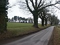 Caistor Lane, Caistor St Edmund - geograph.org.uk - 117944.jpg 640 × 480; 255 KB
-
 Caistor Lane, Caistor St Edmund - geograph.org.uk - 117946.jpg 640 × 480; 236 KB
-
 Caistor St Edmund chalk pit in the snow - geograph.org.uk - 1656960.jpg 640 × 480; 126 KB
-
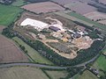 Chalk pit, Caistor St Edmund (aerial) - geograph.org.uk - 40516.jpg 640 × 479; 60 KB
-
 Crossing Boudica's Way - geograph.org.uk - 1656823.jpg 640 × 529; 131 KB
-
 Entrance To Quarry - geograph.org.uk - 1589240.jpg 640 × 480; 91 KB
-
 Fields and footpath, Caistor St Edmund - geograph.org.uk - 117948.jpg 640 × 480; 242 KB
-
 Fields, Caistor St Edmund - geograph.org.uk - 117943.jpg 640 × 480; 230 KB
-
 Fields, near Caistor St Edmund - geograph.org.uk - 117933.jpg 640 × 480; 207 KB
-
 Fields, near Caistor St Edmund - geograph.org.uk - 117934.jpg 640 × 480; 212 KB
-
 Fingerpost at footpath junction - geograph.org.uk - 1378775.jpg 480 × 640; 166 KB
-
 Footpath in the snow - geograph.org.uk - 1656720.jpg 640 × 480; 110 KB
-
 Footpath to Arminghall - geograph.org.uk - 1656711.jpg 640 × 480; 71 KB
-
 Footpath to Arminghall - geograph.org.uk - 1656733.jpg 640 × 480; 130 KB
-
 Footpath to Arminghall - geograph.org.uk - 1656830.jpg 597 × 600; 133 KB
-
 Footpath to Stoke Road - geograph.org.uk - 1656754.jpg 640 × 480; 106 KB
-
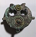 Iceni plate brooch.jpg 1,893 × 1,962; 1.32 MB
-
 Path to Arminghall Lane - geograph.org.uk - 1772126.jpg 480 × 640; 88 KB
-
 Public footpath to Lakenham - geograph.org.uk - 1378782.jpg 640 × 480; 69 KB
-

-
 River Tas, Caistor St Edmund - geograph.org.uk - 87346.jpg 480 × 640; 100 KB
-

-
 Snowy fields east of Stoke Road - geograph.org.uk - 1656850.jpg 640 × 480; 102 KB
-
 Snowy fields east of Stoke Road - geograph.org.uk - 1656920.jpg 640 × 480; 117 KB
-
 The chalk pit by Caistor St Edmund - geograph.org.uk - 1656975.jpg 640 × 501; 137 KB
-
 Track to Arminghall Wood - geograph.org.uk - 1378688.jpg 640 × 480; 100 KB
-
 View across bridge over the River Tas - geograph.org.uk - 1541749.jpg 640 × 449; 106 KB
-
 View from Chapel Hill - geograph.org.uk - 2298190.jpg 640 × 480; 135 KB
-
 View into Arminghall Wood - geograph.org.uk - 1378753.jpg 480 × 640; 162 KB
-

-

-
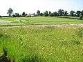
 Wild flower meadow - geograph.org.uk - 1378710.jpg 640 × 480; 66 KB
-
 Wintry fields by Caistor St Edmund - geograph.org.uk - 1656748.jpg 640 × 501; 113 KB
-
 Closed Country Lane, Harford - geograph.org.uk - 709799.jpg 640 × 480; 98 KB
-
 Derelict Farm Cottages, Harford Farm - geograph.org.uk - 709813.jpg 640 × 471; 86 KB


_-_geograph.org.uk_-_40516.jpg)


_along_the_River_Tas_-_geograph.org.uk_-_1541764.jpg)
_along_the_River_Tas_-_geograph.org.uk_-_1541767.jpg)


