Category:Black and white photographs of Shropshire
Jump to navigation
Jump to search
Ceremonial counties of England: Bedfordshire · Berkshire · Buckinghamshire · Cambridgeshire · Cheshire · Cornwall · Cumbria · Derbyshire · Devon · Dorset · Durham · East Riding of Yorkshire · East Sussex · Essex · Gloucestershire · Greater London · Greater Manchester · Hampshire · Herefordshire · Hertfordshire · Isle of Wight · Kent · Lancashire · Leicestershire · Lincolnshire · Merseyside · Norfolk · North Yorkshire · Northamptonshire · Northumberland · Nottinghamshire · Oxfordshire · Rutland · Shropshire · Somerset · South Yorkshire · Staffordshire · Suffolk · Surrey · Tyne and Wear · Warwickshire · West Midlands · West Sussex · West Yorkshire · Wiltshire · Worcestershire
City-counties: Bristol ·
Former historic counties:
Other former counties:
City-counties: Bristol ·
Former historic counties:
Other former counties:

Media in category "Black and white photographs of Shropshire"
The following 117 files are in this category, out of 117 total.
-
 "Adams" chair Bucknell (1294419).jpg 1,000 × 713; 125 KB
-
 "The Cottage" Bucknell (1293886).jpg 1,000 × 710; 102 KB
-
 'Bucknell' from the Knowle (1294640).jpg 1,000 × 707; 99 KB
-
 'In the fields' 'evening' (near Bucknell) (1294730).jpg 1,000 × 711; 76 KB
-
 'Lingen bridge' Bucknell (1294864).jpg 1,000 × 714; 130 KB
-
 'On the river' 'Bucknell' (1294206).jpg 1,000 × 1,376; 209 KB
-
 'Park View' (1293924).jpg 1,000 × 716; 89 KB
-
 'River scene' Bucknell (1295042).jpg 1,000 × 718; 110 KB
-
 'The weir' Bucknell (1294000).jpg 1,000 × 717; 140 KB
-
 60163 Tornado at Highley on a wintry day.jpg 4,592 × 2,583; 2.76 MB
-

-
 Aqueduct over Duke's Drive - geograph.org.uk - 1354739.jpg 640 × 531; 69 KB
-

-
 Bedford OWB at Trench - geograph.org.uk - 1323080.jpg 640 × 468; 47 KB
-
 Bucknell (1294831).jpg 1,000 × 701; 129 KB
-
 Bucknell bridge (1293724).jpg 1,000 × 710; 107 KB
-
 Bucknell church "spring" (1293368) (cropped).jpg 338 × 507; 21 KB
-
 Bucknell church "spring" (1293368).jpg 1,000 × 713; 100 KB
-
 Bucknell church (1294073).jpg 1,000 × 714; 88 KB
-
 Bucknell church (1294863).jpg 1,000 × 708; 90 KB
-
 Bucknell church porch (1294189).jpg 1,000 × 707; 129 KB
-
 Bucknell from Lampitts (1293379).jpg 1,000 × 703; 66 KB
-
 Bucknell from the Knoll (1294523).jpg 1,000 × 704; 75 KB
-
 Bucknell post office (1294739).jpg 1,000 × 704; 111 KB
-
 Bucknell school (1293428).jpg 1,000 × 716; 102 KB
-

-

-

-
 Chancel Clungunford church (1294972).jpg 1,000 × 720; 106 KB
-
 Church of St. Mary's, Bromfield. Wellcome M0001279.jpg 1,587 × 1,153; 499 KB
-
 Clun church chancel and altar (1294672).jpg 1,000 × 709; 105 KB
-
 Clun parish church (1294097).jpg 1,000 × 711; 110 KB
-
 Clun parish church (1294146).jpg 1,000 × 708; 87 KB
-
 Clun parish church (1294442).jpg 1,000 × 693; 77 KB
-
 Clungunford church (1294113).jpg 1,000 × 711; 94 KB
-
 Clungunford church (1294503).jpg 1,000 × 730; 72 KB
-
 Clungunford church (98A) (1294413).jpg 1,000 × 709; 89 KB
-
 Coalport West railway station in 1963.jpg 640 × 489; 95 KB
-

-
 Coxall chapel Bucknell (1293883).jpg 1,000 × 712; 81 KB
-
 Coxall chapel Bucknell (1294109).jpg 1,000 × 716; 78 KB
-
 Eagle Coaches garage, Trench - geograph.org.uk - 1323095.jpg 640 × 524; 51 KB
-
 East window Clun church (1295064).jpg 1,000 × 1,408; 165 KB
-
 Edmonds-Watkins wedding at St Giles, Shrewsbury (5410993136).jpg 444 × 602; 52 KB
-
 Ellesmere BWB Yard - geograph.org.uk - 520747.jpg 640 × 503; 81 KB
-
 Eyton Lock, Shrewsbury Canal, Shropshire - geograph.org.uk - 254384.jpg 640 × 491; 105 KB
-
 Ferney Hall. Happy New Year (1293803).jpg 1,000 × 714; 127 KB
-
 Field, Mynde - geograph.org.uk - 3151265.jpg 640 × 360; 218 KB
-
 Frankton Junction, Llangollen Canal - geograph.org.uk - 520451.jpg 640 × 473; 86 KB
-
 Frankton Junction, Llangollen Canal - geograph.org.uk - 520725.jpg 640 × 507; 131 KB
-

-
 Goesland Steam Sawmill - geograph.org.uk - 377340.jpg 516 × 640; 86 KB
-

-
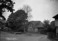
 Green Farm - geograph.org.uk - 234303.jpg 640 × 480; 70 KB
-
-

-
 Hopton Castle church (1294886) (cropped).jpg 800 × 573; 60 KB
-
 Hopton Castle church (1294886).jpg 1,000 × 717; 96 KB
-

-

-
 In Bucknell church (1294949).jpg 1,000 × 1,409; 139 KB
-
 Ironbridge in Black and White.jpg 1,280 × 853; 211 KB
-
 Ironbridge railway station in 1963.jpg 640 × 537; 112 KB
-
-
 Knighton station - geograph.org.uk - 477511.jpg 640 × 472; 90 KB
-
 Ludlow Castle - geograph.org.uk - 2783410.jpg 700 × 500; 209 KB
-
 Ludlow High Street in 1965 - geograph.org.uk - 2838903.jpg 606 × 640; 108 KB
-
 Memorial hall Bucknell (1294822).jpg 1,000 × 708; 74 KB
-

-

-

-
 P.M. chapel Bucknell (1293513).jpg 1,000 × 711; 101 KB
-
 P.M. chapel Bucknell (3451537716).jpg 750 × 533; 139 KB
-
 Interior of the church, Pontesbury (Salop) NLW3361572.jpg 603 × 456; 40 KB
-
 The church, Pontesbury (Salop) NLW3361574 (cropped).jpg 455 × 344; 52 KB
-
 The church, Pontesbury (Salop) NLW3361574.jpg 603 × 456; 54 KB
-
 The church, Pontesbury (Salop) NLW3361575.jpg 609 × 463; 54 KB
-
 R.G.E. Car Repairs, Bucknell - geograph.org.uk - 2381658.jpg 640 × 444; 42 KB
-
-
 River scene Bucknell (1293444).jpg 1,000 × 701; 170 KB
-

-
 Schoolyard Bucknell (1294288).jpg 1,000 × 1,397; 262 KB
-
 Sentinel at Oakengates - geograph.org.uk - 1323364.jpg 640 × 461; 50 KB
-
 Shrewsbury, Butchers Row (8570744301).jpg 559 × 800; 293 KB
-
 Shrewsbury, Street View - Pride Hill and New Market (8570636091).jpg 1,000 × 698; 511 KB
-
 Station Road Bucknell (1293808).jpg 1,000 × 717; 121 KB
-
 Stekesley Castle in 1854 by Eliz Guppy.jpg 240 × 300; 80 KB
-
 Stokesay Castle from the church Yard, Shropshire (O55692).jpg 768 × 523; 80 KB
-
 Stokesay Castle in c1935 - geograph.org.uk - 3349054.jpg 1,107 × 746; 162 KB
-
 Stokesay Castle, Shropshire (O55690).jpg 768 × 564; 92 KB
-
 Stokesay Castle, Shropshire (O55694).jpg 768 × 500; 85 KB
-
 Stokesay Castle, Shropshire (O55696).jpg 581 × 768; 98 KB
-
 Stokesay-Castle-Window-in-South-Tower.jpg 944 × 1,353; 110 KB
-
 Teagues Bridge Lane, Trench - geograph.org.uk - 1351669.jpg 640 × 492; 49 KB
-
 Thatched cottage, Bucknell (1293395).jpg 1,000 × 1,430; 181 KB
-
 Thatched house, Westbury (Salop) NLW3363975.jpg 580 × 433; 67 KB
-
 The "improved" causeway Bucknell (1293919).jpg 1,000 × 711; 100 KB
-
 The "Old Mill" Bucknell (1293805).jpg 1,000 × 718; 91 KB
-
 The "Old Mill" Bucknell (1295004).jpg 1,000 × 1,371; 139 KB
-
 The "scrubs" Bucknell (1294335).jpg 1,000 × 727; 68 KB
-
 The 'Blue Pig', Trench, Shropshire - geograph.org.uk - 645422.jpg 640 × 551; 58 KB
-
 The Coalport Branch - geograph.org.uk - 1356838.jpg 640 × 422; 46 KB
-
 The Feathers Hotel (119956335).jpeg 1,355 × 2,048; 834 KB
-

-
 The river Bucknell (1293701).jpg 1,000 × 715; 92 KB
-
 The rly crossing (1294407).jpg 1,000 × 709; 90 KB
-
 The square Bucknell (1294541).jpg 1,000 × 713; 110 KB
-
 The square Bucknell (1295069).jpg 1,000 × 716; 86 KB
-

-
 Trench Crossing station - geograph.org.uk - 358734.jpg 640 × 536; 97 KB
-
 Trench Pool - geograph.org.uk - 1354506.jpg 640 × 532; 64 KB
-
 View of St. Mary's Church from bridge, stream and poplars. Wellcome M0001281.jpg 1,597 × 1,147; 624 KB
-
 View towards Wappenshall Junction - geograph.org.uk - 1354755.jpg 640 × 436; 64 KB
-
 Wappenshall Junction, Shrewsbury Canal - geograph.org.uk - 335323.jpg 640 × 465; 105 KB
-
 Weir cottage Bucknell (1294091).jpg 1,000 × 711; 117 KB
-
 Weir house Bucknell (1295114).jpg 1,000 × 710; 109 KB
-
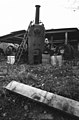 Goesland Steam Sawmill, Neen Savage - geograph.org.uk - 374178.jpg 422 × 640; 64 KB
.jpg)
.jpg)
.jpg)
_(1294730).jpg)
.jpg)
.jpg)
.jpg)
.jpg)
.jpg)


.jpg)
.jpg)
_(cropped).jpg)
.jpg)
.jpg)
.jpg)
.jpg)
.jpg)
.jpg)
.jpg)
.jpg)


.jpg)
.jpg)

.jpg)
.jpg)
.jpg)
.jpg)
.jpg)
.jpg)
_(1294413).jpg)

.jpg)
.jpg)
.jpg)

.jpg)
.jpg)


.jpg)


_(cropped).jpg)
.jpg)


.jpg)


.jpg)


.jpg)
.jpg)
_NLW3361572.jpg)
_NLW3361574_(cropped).jpg)
_NLW3361574.jpg)
_NLW3361575.jpg)


.jpg)

.jpg)

.jpg)
.jpg)
.jpg)

.jpg)

.jpg)
.jpg)
.jpg)


.jpg)
_NLW3363975.jpg)
.jpg)
.jpg)
.jpg)
.jpg)


.jpeg)

.jpg)
.jpg)
.jpg)
.jpg)


.jpg)
.jpg)
