Category:Aerial photographs of the United States
Jump to navigation
Jump to search
Countries of the Americas: Argentina · The Bahamas · Barbados · Belize · Bolivia · Brazil · Canada · Chile · Colombia · Costa Rica · Cuba · Dominica · Dominican Republic · Ecuador · El Salvador · Grenada · Guatemala · Haiti · Honduras · Jamaica · Mexico · Nicaragua · Panama · Paraguay · Peru · Saint Kitts and Nevis · Suriname · Trinidad and Tobago · United States of America · Uruguay · Venezuela
Other areas: Anguilla · Aruba · Bermuda · British Virgin Islands · Cayman Islands · Curaçao · Falkland Islands · French Guiana · Greenland · Guadeloupe · Martinique · Montserrat · Puerto Rico · Saint Barthélemy · Saint Pierre and Miquelon · Turks and Caicos Islands · United States Virgin Islands
Other areas: Anguilla · Aruba · Bermuda · British Virgin Islands · Cayman Islands · Curaçao · Falkland Islands · French Guiana · Greenland · Guadeloupe · Martinique · Montserrat · Puerto Rico · Saint Barthélemy · Saint Pierre and Miquelon · Turks and Caicos Islands · United States Virgin Islands
Español: Fotografías aéreas de los Estados Unidos
Subcategories
This category has the following 18 subcategories, out of 18 total.
A
B
N
Media in category "Aerial photographs of the United States"
The following 200 files are in this category, out of 403 total.
(previous page) (next page)-

-
-

-

-

-
-
-

-
-

-
-

-
 181027-F-IO108-001.jpg 5,499 × 3,665; 5.3 MB
-
 231118-2 Kiwanis Lake.jpg 8,064 × 6,048; 45.1 MB
-
 231119-11 Desert Breeze Lake.jpg 8,064 × 6,048; 50.76 MB
-
 AA Flight from DFW - YKA - (26362145333).jpg 3,771 × 2,514; 4.11 MB
-
-

-

-
-

-

-
 Aerial ignition interior high rates of spread in open savannas.jpg 3,264 × 2,448; 509 KB
-
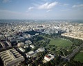 Aerial of Washington, D.C LCCN2011630842.tif 6,171 × 4,879; 86.17 MB
-
 Aerial of Washington, D.C LCCN2011632843.tif 2,270 × 1,516; 19.72 MB
-
 Aerial photography (San francisco-philadelphia) 1.jpg 1,712 × 2,560; 765 KB
-
 Aerial photography (San francisco-philadelphia) 10.jpg 1,712 × 2,560; 754 KB
-
 Aerial photography (San francisco-philadelphia) 11.jpg 1,712 × 2,560; 855 KB
-
 Aerial photography (San francisco-philadelphia) 12.jpg 1,712 × 2,560; 736 KB
-
 Aerial photography (San francisco-philadelphia) 13.jpg 1,712 × 2,560; 848 KB
-
 Aerial photography (San francisco-philadelphia) 14.jpg 2,560 × 1,712; 808 KB
-
 Aerial photography (San francisco-philadelphia) 15.jpg 1,712 × 2,560; 768 KB
-
 Aerial photography (San francisco-philadelphia) 16.jpg 1,712 × 2,560; 811 KB
-
 Aerial photography (San francisco-philadelphia) 17.jpg 1,712 × 2,560; 877 KB
-
 Aerial photography (San francisco-philadelphia) 18.jpg 1,712 × 2,560; 895 KB
-
 Aerial photography (San francisco-philadelphia) 19.jpg 1,712 × 2,560; 938 KB
-
 Aerial photography (San francisco-philadelphia) 2.jpg 1,712 × 2,560; 723 KB
-
 Aerial photography (San francisco-philadelphia) 20.jpg 1,712 × 2,560; 820 KB
-
 Aerial photography (San francisco-philadelphia) 21.jpg 1,712 × 2,560; 731 KB
-
 Aerial photography (San francisco-philadelphia) 22.jpg 1,712 × 2,560; 805 KB
-
 Aerial photography (San francisco-philadelphia) 23.jpg 1,712 × 2,560; 767 KB
-
 Aerial photography (San francisco-philadelphia) 24.jpg 1,712 × 2,560; 802 KB
-
 Aerial photography (San francisco-philadelphia) 25.jpg 1,712 × 2,560; 854 KB
-
 Aerial photography (San francisco-philadelphia) 26.jpg 1,712 × 2,560; 812 KB
-
 Aerial photography (San francisco-philadelphia) 27.jpg 1,712 × 2,560; 793 KB
-
 Aerial photography (San francisco-philadelphia) 28.jpg 2,560 × 1,712; 829 KB
-
 Aerial photography (San francisco-philadelphia) 29.jpg 2,560 × 1,712; 840 KB
-
 Aerial photography (San francisco-philadelphia) 3.jpg 1,712 × 2,560; 615 KB
-
 Aerial photography (San francisco-philadelphia) 30.jpg 1,712 × 2,560; 915 KB
-
 Aerial photography (San francisco-philadelphia) 31.jpg 2,560 × 1,712; 838 KB
-
 Aerial photography (San francisco-philadelphia) 32.jpg 1,712 × 2,560; 941 KB
-
 Aerial photography (San francisco-philadelphia) 33.jpg 1,712 × 2,560; 871 KB
-
 Aerial photography (San francisco-philadelphia) 34.jpg 1,712 × 2,560; 917 KB
-
 Aerial photography (San francisco-philadelphia) 35.jpg 2,560 × 1,712; 868 KB
-
 Aerial photography (San francisco-philadelphia) 36.jpg 1,712 × 2,560; 725 KB
-
 Aerial photography (San francisco-philadelphia) 4.jpg 1,712 × 2,560; 653 KB
-
 Aerial photography (San francisco-philadelphia) 5.jpg 1,712 × 2,560; 835 KB
-
 Aerial photography (San francisco-philadelphia) 6.jpg 1,712 × 2,560; 787 KB
-
 Aerial photography (San francisco-philadelphia) 7.jpg 1,712 × 2,560; 788 KB
-
 Aerial photography (San francisco-philadelphia) 8.jpg 1,712 × 2,560; 819 KB
-
 Aerial photography (San francisco-philadelphia) 9.jpg 1,712 × 2,560; 852 KB
-
 Aerial shots-DFW to YVR-last sunset (6996036745).jpg 2,121 × 1,414; 1.86 MB
-
 Aerial shots-Vancouver to Dallas-Fort Worth (6849854542).jpg 2,116 × 1,417; 2.36 MB
-
 Aerial shots-Vancouver to Dallas-Fort Worth (6849854940).jpg 2,121 × 1,414; 1.46 MB
-

-

-

-

-
-

-
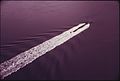
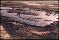
 AERIAL VIEW OF CAMPERS ON A BEACH AT PYRAMID LAKE - NARA - 552915.jpg 3,000 × 2,019; 654 KB
-
-

-

-

-

-

-
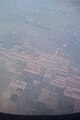
 Aerial view of flooded farm land - NARA - 285950.jpg 3,000 × 2,356; 3.53 MB
-

-
 Aerial view of Northern Virginia in the Washington, D.C., suburbs LCCN2011634139.tif 5,117 × 6,312; 184.84 MB
-
 Aerial view of Northern Virginia in the Washington, D.C., suburbs LCCN2011634140.tif 4,280 × 5,410; 132.52 MB
-
 Aerial view of Northern Virginia near Washington, D.C LCCN2011633716.tif 6,106 × 4,788; 167.32 MB
-
 Aerial view of Northern Virginia near Washington, D.C LCCN2011633717.tif 5,882 × 4,272; 143.81 MB
-
-

-

-

-

-

-
 Aerial view of Pennsylvania Avenue, Washington, D.C LCCN2011632909.tif 1,476 × 2,241; 18.96 MB
-
 Aerial view of San Francisco, California, with downtown in the distance LCCN2011634618.tif 6,070 × 4,746; 164.87 MB
-

-
-
-
 Aerial view of southwest, Washington, D.C LCCN2011632824.tif 2,310 × 1,546; 20.46 MB
-

-
 Aerial view of the Acela Amtrak train doing a test run in New England LCCN2011632961.tif 2,265 × 1,476; 19.16 MB
-
 Aerial view of the central California coast LCCN2011634717.tif 6,181 × 4,578; 161.94 MB
-
 Aerial view of the central California coast LCCN2011634718.tif 6,175 × 4,622; 163.33 MB
-
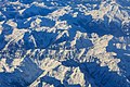
 Aerial view of the central California coastal mountains LCCN2011634749.tif 6,372 × 4,860; 177.22 MB
-

-
-

-

-
-
-

-

-

-
 Aerial view of the Korean Memorial, Washington, D.C LCCN2011632904.tif 2,273 × 1,513; 19.71 MB
-
 Aerial view of the Korean Memorial, Washington, D.C LCCN2011632905.tif 2,306 × 1,510; 19.95 MB
-

-

-
 Aerial view of the U.S. Treasury Building, Washington, D.C LCCN2011632910.tif 2,316 × 1,529; 20.29 MB
-
 Aerial view of the Washington Navy Yard, Washington, D.C LCCN2011634490.tif 5,653 × 4,463; 144.39 MB
-
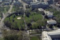 Aerial view of the White House, Washington, D.C LCCN2011632842.tif 2,292 × 1,523; 20 MB
-
 Aerial view of Thomas Circle, Washington, D.C LCCN2011634107.tif 6,477 × 5,120; 189.79 MB
-
 Aerial view of Washington, D.C LCCN2011632507.tif 5,242 × 3,509; 105.28 MB
-
 Aerial view of Washington, D.C LCCN2011632702.tif 2,299 × 1,475; 19.43 MB
-
 Aerial view of Washington, D.C LCCN2011632775.tif 2,265 × 1,548; 20.09 MB
-
 Aerial view of Washington, D.C LCCN2011632776.tif 2,224 × 1,523; 19.41 MB
-
 Aerial view of Washington, D.C LCCN2011632777.tif 2,262 × 1,497; 19.41 MB
-
 Aerial view of Washington, D.C LCCN2011632779.tif 2,273 × 1,516; 19.75 MB
-
 Aerial view of Washington, D.C LCCN2011632780.tif 2,258 × 1,511; 19.55 MB
-
 Aerial view of Washington, D.C LCCN2011632781.tif 2,264 × 1,513; 19.63 MB
-
 Aerial view of Washington, D.C LCCN2011632788.tif 2,295 × 1,534; 20.17 MB
-
 Aerial view of Washington, D.C LCCN2011632797.tif 2,301 × 1,530; 20.17 MB
-
 Aerial view of Washington, D.C LCCN2011632802.tif 2,284 × 1,549; 20.27 MB
-
 Aerial view of Washington, D.C LCCN2011632803.tif 2,272 × 1,521; 19.8 MB
-
 Aerial view of Washington, D.C LCCN2011632804.tif 2,292 × 1,530; 20.09 MB
-
 Aerial view of Washington, D.C LCCN2011632805.tif 2,276 × 1,519; 19.81 MB
-
 Aerial view of Washington, D.C LCCN2011632806.tif 2,266 × 1,522; 19.76 MB
-
 Aerial view of Washington, D.C LCCN2011632808.tif 2,264 × 1,508; 19.56 MB
-
 Aerial view of Washington, D.C LCCN2011632809.tif 2,318 × 1,557; 20.68 MB
-
 Aerial view of Washington, D.C LCCN2011632810.tif 2,273 × 1,510; 19.67 MB
-
 Aerial view of Washington, D.C LCCN2011632811.tif 2,291 × 1,506; 19.77 MB
-
 Aerial view of Washington, D.C LCCN2011632817.tif 2,310 × 1,546; 20.46 MB
-
 Aerial view of Washington, D.C LCCN2011632820.tif 2,307 × 1,526; 20.17 MB
-
 Aerial view of Washington, D.C LCCN2011632823.tif 2,183 × 1,410; 17.64 MB
-
 Aerial view of Washington, D.C LCCN2011632847.tif 2,207 × 1,499; 18.96 MB
-
 Aerial view of Washington, D.C LCCN2011632848.tif 2,318 × 1,527; 20.28 MB
-
 Aerial view of Washington, D.C LCCN2011632853.tif 2,256 × 1,522; 19.67 MB
-
 Aerial view of Washington, D.C LCCN2011633671.tif 5,727 × 4,167; 136.58 MB
-
 Aerial view of Washington, D.C LCCN2011633728.tif 6,037 × 4,819; 166.5 MB
-
 Aerial view of Washington, D.C LCCN2011633811.tif 6,174 × 4,659; 164.62 MB
-

-

-
 Aerial view of wetland pond.jpg 2,100 × 1,370; 268 KB
-

-
-

-

-
 Aerial view panorama LCCN2011634384.tif 9,318 × 2,916; 155.5 MB
-
 Aerial view panorama LCCN2011634385.tif 9,100 × 2,841; 147.95 MB
-
 Aerial view showing the Las Vegas Strip at dusk, Las Vegas, Nevada LCCN2011634444.tif 5,931 × 3,802; 129.05 MB
-
 Aerial view showing the Luxor Hotel Sphynx and Pyramid, Las Vegas, Nevada LCCN2011634550.tif 5,692 × 3,117; 101.55 MB
-

-

-
-

-

-

-

-
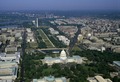
 Aerial view with a focus on the National Mall, Washington, D.C LCCN2011635082.tif 7,407 × 5,455; 231.23 MB
-

-

-
 Aerial view with Franklin Square Park in the foreground. Washington, D.C LCCN2011633719.tif 6,064 × 4,818; 167.21 MB
-
 Aerial view, Northridge (6042674947).jpg 4,320 × 2,432; 4.55 MB
-
 Aerial view, San Francisco, California LCCN2011631765.tif 6,901 × 5,422; 214.13 MB
-
 Aerial view, San Francisco, California LCCN2011631766.tif 6,639 × 5,096; 193.62 MB
-

-

-
 Aerial, Dallas suburbs (6044627600).jpg 4,320 × 3,240; 4.63 MB
-
 Aerial, Indian Creek near Dallas (6039814731).jpg 4,320 × 2,432; 4.15 MB
-
 Aerial, townscape (6044083227).jpg 4,320 × 3,240; 4.19 MB
-
 Aerial, Van Norman Lake & Newhall Pass (6042660973).jpg 4,193 × 2,360; 3.53 MB
-
 Air shots from Seattle to Miami (15696371919).jpg 2,121 × 1,414; 1.88 MB
-
 Air shots from Seattle to Miami-shadowy Miami skyline (15695091790).jpg 2,121 × 1,414; 2.06 MB
-
 Alexandria, Virginia (6045513083).jpg 3,240 × 4,320; 5.54 MB
-
 American homes and gardens (1911) (18153302052).jpg 2,818 × 1,376; 1.14 MB
-
 An aerial view of urban sprawl population density.jpg 3,022 × 2,033; 1,004 KB
-
 Annapolis Maryland RAAM 2015 by D Ramey Logan with Grant Jensen.jpg 1,822 × 919; 1.14 MB
-
 Annapolis Maryland wide by Don Ramey Logan.jpg 1,493 × 485; 591 KB
-

-

-

-
-
-
 Appalachian Landscape (6044585820).jpg 4,320 × 3,240; 3.27 MB
-
 Arlington National Cemetery, Aerial (6039793367).jpg 3,983 × 2,242; 3.24 MB
-
 Atmosphere (6044045761).jpg 4,320 × 3,240; 3.08 MB
-
 Bell telephone magazine (1922) (14569762108).jpg 2,688 × 2,004; 1.84 MB
-
 Big forest fire from plane.jpg 2,100 × 1,576; 98 KB
-
 BinghamCanyon.jpg 4,288 × 2,848; 4.07 MB
-
 Boathouse on the Potomac.jpg 1,082 × 1,623; 615 KB
-
 Breach at Trustom Pond (RI) (8158421878).jpg 5,616 × 3,744; 5.43 MB
-

-
 Burbank, Tujunga Wash (6042694655).jpg 2,432 × 4,320; 3.61 MB
-
 Capital Beltway, Virginia & Maryland (6046054400).jpg 4,320 × 3,240; 4.13 MB
-
 Cascata golf course from the air July 2014.jpg 5,882 × 2,282; 3.06 MB
_412-DSP-2-WEDarials_022.jpg_-_DPLA_-_ee500f413ab6bdcce6ffdca951c62f59.jpg)
_412-DSP-2-WEDarials_044.jpg_-_DPLA_-_157076fc92de5d87659defb829ca550c.jpg)
_412-DSP-2-WEDarials_071.jpg_-_DPLA_-_a8d3f54d9fa6dda58805fb4c9d94739a.jpg)
_412-DSP-2-WEDarials_107.jpg_-_DPLA_-_a0279a664be3accf1e2537506e91204e.jpg)
_412-DSP-2-WEDarials_116.jpg_-_DPLA_-_0e0e521c54202773f741c97a282b344b.jpg)
_412-DSP-2-WEDarials_134.jpg_-_DPLA_-_be1aa06cedd31684e63cdbcb83e8d043.jpg)
_412-DSP-2-WEDarials_135.jpg_-_DPLA_-_3d828d23aa374aa17686167e94b748b3.jpg)
_412-DSP-2-WEDarials_155.jpg_-_DPLA_-_53148c5c6c8b0893704c121e3d2a9698.jpg)
_412-DSP-2-WEDarials_161.jpg_-_DPLA_-_993c9cd308f0c7151c0a812b59538b1d.jpg)
_412-DSP-2-WEDarials_237.jpg_-_DPLA_-_25b3fa618e118fba8032802ead39343c.jpg)
_412-DSP-2-WEDarials_261.jpg_-_DPLA_-_0faba8c3ea5740a2e605a4130b968581.jpg)
_412-DSP-2-WEDarials_282.jpg_-_DPLA_-_88327030d1c322161219b829d40531b9.jpg)


.jpg)
.jpg)
.jpg)
.jpg)
.jpg)
.jpg)
.jpg)

_1.jpg)
_10.jpg)
_11.jpg)
_12.jpg)
_13.jpg)
_14.jpg)
_15.jpg)
_16.jpg)
_17.jpg)
_18.jpg)
_19.jpg)
_2.jpg)
_20.jpg)
_21.jpg)
_22.jpg)
_23.jpg)
_24.jpg)
_25.jpg)
_26.jpg)
_27.jpg)
_28.jpg)
_29.jpg)
_3.jpg)
_30.jpg)
_31.jpg)
_32.jpg)
_33.jpg)
_34.jpg)
_35.jpg)
_36.jpg)
_4.jpg)
_5.jpg)
_6.jpg)
_7.jpg)
_8.jpg)
_9.jpg)
.jpg)
.jpg)
.jpg)


.jpeg)


.jpg)
.jpg)
.jpg)
.jpg)
.jpg)
.jpg)
.jpg)
.jpg)
_(18153302052).jpg)


.jpg)
.jpg)
.jpg)
.jpg)
.jpg)
.jpg)
.jpg)
.jpg)
_(14569762108).jpg)


_(8158421878).jpg)
_(8157809040).jpg)
.jpg)
.jpg)