Category:Aerial photographs of rivers of the United States
Jump to navigation
Jump to search

Subcategories
This category has the following 5 subcategories, out of 5 total.
C
I
M
Media in category "Aerial photographs of rivers of the United States"
The following 75 files are in this category, out of 75 total.
-
 Aerial view of Agua Fria National Monument, Arizona.jpg 3,024 × 4,032; 2.39 MB
-
 Aerial view of bandon marsh national wildlife refuge.jpg 1,708 × 2,471; 647 KB
-

-
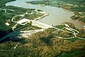
 Aerial view of McAlpine Locks circa 2000.jpg 3,000 × 1,995; 2.21 MB
-
 Aerial View of Pacific City, Oregon.JPG 6,016 × 4,000; 9.45 MB
-
 Aerial view of Pittsburgh area.jpg 4,318 × 3,083; 5.18 MB
-

-
 Aerial view of Sacramento.jpg 2,272 × 1,704; 926 KB
-
 Aerial view of Schenectady County Airport.jpg 3,572 × 2,135; 2.75 MB
-

-
 Aerial view of the Platte River and I-80 at Gothenburg, Nebraska.jpg 3,024 × 4,032; 2.97 MB
-
 Aerial view of the St. Clair River and Lake St. Clair.jpg 3,024 × 4,032; 2.26 MB
-

-
 Aerial view of Willamette River at Corvallis, Oregon (6443607311).jpg 4,145 × 2,862; 1.43 MB
-
 Alsea River.jpg 4,246 × 2,820; 3.29 MB
-
 Atchison-bridges-2011-flood.jpg 1,000 × 750; 727 KB
-
 Bridges across flooded river - NARA - 285951.jpg 3,000 × 2,363; 3.97 MB
-
 Burnt River dam.jpg 350 × 230; 104 KB
-
 CALIFORNIA--KINGS RIVER - NARA - 542517.jpg 2,004 × 3,000; 5.25 MB
-
 CALIFORNIA--SAN JOAQUIN VALLEY - NARA - 542510.jpg 3,000 × 2,045; 3.23 MB
-
 Cleveland Ohio 1937.jpg 1,422 × 1,080; 351 KB
-
 Cochecton-Damascus Bridge April 2023.jpg 4,000 × 3,000; 4.76 MB
-
 Confluence of the Missouri and Mississippi rivers.jpg 690 × 711; 91 KB
-
 Connecticut River from the Air.jpg 6,000 × 3,702; 17.45 MB
-

-

-
 Coquille River aerial.jpg 1,024 × 683; 522 KB
-
 Corp of Eng. 6-15-11 137.JPG 3,727 × 2,426; 4.29 MB
-

-
 Downtown Cleveland, Ohio, in winter, from the air, 12-1937 - NARA - 512842.jpg 3,000 × 2,275; 1.73 MB
-
 Downtown Elkhart, Indiana (14023911580).jpg 4,000 × 3,000; 2.49 MB
-
 Downtown Elkhart, Indiana (14230707403).jpg 4,000 × 3,000; 2.7 MB
-
 Elkhart, Indiana (14023873488).jpg 4,000 × 3,000; 2.41 MB
-
 Elkhart, Indiana (14023874319).jpg 4,000 × 3,000; 2.5 MB
-
 Elkhart, Indiana (14023956747).jpg 4,000 × 3,000; 2.33 MB
-
 Elkhart, Indiana (14210389064).jpg 4,000 × 3,000; 2.79 MB
-
 Elkhart, Indiana (14210393894).jpg 4,000 × 3,000; 2.73 MB
-
 Elkhart, Indiana (7992994403).jpg 4,000 × 3,000; 1.91 MB
-
 Firth river Arctic national wildlife refuge.jpg 3,678 × 2,400; 707 KB
-
 FlorenceAir.jpg 484 × 280; 60 KB
-
 Fontana Lake, North Carolina.jpg 2,448 × 3,264; 1.43 MB
-
 Ottawa, Illinois (7981644021).jpg 4,000 × 3,000; 2.1 MB
-
 French King Bridge Massachusetts October 2021 003.jpg 5,464 × 3,640; 8.51 MB
-
 Grande Ronde River aerial.jpg 2,552 × 1,912; 1.73 MB
-
 Green river utah from sky.jpg 1,200 × 1,600; 495 KB
-
 High altitude view of Tennessee River at Humphreys County, Tennessee.jpg 4,320 × 3,240; 4.47 MB
-
 Imnaha River aerial.jpg 4,288 × 2,848; 3.53 MB
-
 Just East of Elkhart, Indiana (7238202030).jpg 4,000 × 3,000; 1.98 MB
-
 Klamath River mouth aerial view.jpg 1,500 × 1,001; 671 KB
-
 LaX river.png 2,580 × 1,116; 4.26 MB
-
 Louisville Flight (101324757).jpg 1,600 × 1,200; 663 KB
-
 Louisville, Kentucky bridge crossings.jpg 4,608 × 3,456; 5.6 MB
-
 Norman Wood Bridge Aerial.jpg 3,000 × 1,200; 3.86 MB
-
 Cairo Illinois 1997 USGS.jpg 2,032 × 1,320; 353 KB
-
 OH and MS confluence.jpg 439 × 300; 26 KB
-
 Pistol River mouth.jpg 289 × 219; 24 KB
-
 QuadCities Aerial.jpg 2,067 × 1,699; 3.35 MB
-
 Reseda Blvd. crosses the Los Angeles River in Reseda, Los Angeles, California.jpg 4,032 × 3,024; 6.28 MB
-
 Rochester Minnesota downtown aerial view.jpg 1,500 × 1,202; 1.15 MB
-
 Chandlerville, Illinois (7235196678).jpg 4,000 × 3,000; 2 MB
-
 Sheastadiumfromtheair.jpg 800 × 600; 255 KB
-
 Siuslaw River Bridge at Florence OR.jpg 4,226 × 2,806; 3.12 MB
-
 Siuslaw River Pacific Ocean.jpg 1,500 × 991; 424 KB
-
 St. Joseph River Through Elkhart, Indiana (7992993951).jpg 4,000 × 3,000; 1.98 MB
-
 Sycan Marsh.jpg 2,454 × 1,563; 1.47 MB
-
 Trail Oregon.jpg 2,576 × 1,932; 2.11 MB
-
 Umpqua River Pacific Ocean.jpg 1,500 × 993; 420 KB
-
 USACE Big Cliff Dam Oregon.jpg 1,500 × 1,002; 532 KB
-
 USACE Coralville Reservoir Iowa.jpg 1,500 × 1,000; 300 KB
-
 USACE Detroit Dam Oregon.jpg 1,500 × 977; 1.14 MB
-
 USACE Winchester Bay, Umpqua River mouth.jpg 1,500 × 991; 467 KB
-
 Visible Spectrum vs IR.jpg 3,984 × 1,493; 1.09 MB
-
 Walt Whitman Bridge from the air.jpg 3,504 × 2,336; 4.33 MB
-
 Willamette River 1996 flood aerial.jpg 635 × 381; 93 KB
-
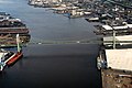
 Wilmington Delaware aerial view.jpg 3,264 × 2,448; 4.12 MB


.jpg)


.jpg)


.jpg)
.jpg)
.jpg)
.jpg)
.jpg)
.jpg)
.jpg)
.jpg)


.jpg)


.jpg)


.jpg)


.jpg)


.jpg)


