Category:Aerial photographs of North Carolina
Jump to navigation
Jump to search
States of the United States: Alabama · Alaska · Arizona · Arkansas · California · Colorado · Connecticut · Delaware · Florida · Georgia · Hawaii · Idaho · Illinois · Indiana · Iowa · Kansas · Kentucky · Louisiana · Maine · Maryland · Massachusetts · Michigan · Minnesota · Mississippi · Missouri · Montana · Nebraska · Nevada · New Hampshire · New Jersey · New Mexico · New York · North Carolina · North Dakota · Ohio · Oklahoma · Oregon · Pennsylvania · Rhode Island · South Carolina · South Dakota · Tennessee · Texas · Utah · Vermont · Virginia · Washington · West Virginia · Wisconsin · Wyoming – District of Columbia: Washington, D.C.
insular area of the United States: American Samoa · Guam · Northern Mariana Islands · Puerto Rico · United States Virgin Islands – United States Minor Outlying Islands: Baker Island · Midway Atoll · Wake Island
insular area of the United States: American Samoa · Guam · Northern Mariana Islands · Puerto Rico · United States Virgin Islands – United States Minor Outlying Islands: Baker Island · Midway Atoll · Wake Island
Subcategories
This category has the following 39 subcategories, out of 39 total.
1
2
A
B
D
Media in category "Aerial photographs of North Carolina"
The following 192 files are in this category, out of 192 total.
-
-
 American Tobacco Company aerial (21952146599).jpg 1,653 × 1,079; 775 KB
-
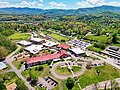
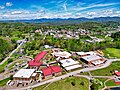
 An aerial photo of a primary school in Hayesville, North Carolina.jpg 4,482 × 2,682; 14.4 MB
-
 Andrews Elementary School in Andrews, North Carolina, and Cherokee County 01.jpg 4,032 × 3,024; 4.71 MB
-
 Andrews Elementary School in Andrews, North Carolina, and Cherokee County 02.jpg 4,032 × 3,024; 4.41 MB
-
 Andrews Elementary School in Andrews, North Carolina, and Cherokee County 03.jpg 4,032 × 3,024; 4.88 MB
-
 Andrews Elementary School in Andrews, North Carolina, and Cherokee County 04.jpg 3,796 × 2,333; 3.09 MB
-
 Andrews High School (AHS) in Andrews, North Carolina and Cherokee County.jpg 2,565 × 1,924; 1.95 MB
-
 Angel Medical Center's former hospital campus in downtown Franklin, NC 01.jpg 4,032 × 3,024; 5.03 MB
-
 Angel Medical Center's former hospital campus in downtown Franklin, NC 03.jpg 4,032 × 3,024; 5.6 MB
-
 Apalachia Dam.jpg 1,842 × 1,236; 2.7 MB
-
 Brasstown, N.C. on Aug. 28, 2022.jpg 8,064 × 6,048; 52.65 MB
-
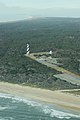
 Currituck Lighthouse Property.jpg 4,032 × 3,024; 4.84 MB
-
 Downtown Hayesville in Clay County, N.C. on June 26, 2022.jpg 3,024 × 2,587; 7.92 MB
-
 Fayetteville, North Carolina (38003455884).jpg 2,400 × 1,600; 2.74 MB
-
 Figure Eight Island Aerial Footage.jpg 5,464 × 3,640; 17.65 MB
-
 Figure Eight Island Aerial Photography.jpg 5,464 × 3,640; 16.35 MB
-
 Figure Eight Island Aerial.jpg 4,788 × 3,589; 15.43 MB
-
 Fort-Raleigh-theater.jpg 899 × 681; 160 KB
-
 Franklin High School in Franklin, NC, and Macon County 01.jpg 4,032 × 3,024; 5.61 MB
-
 Franklin High School in Franklin, NC, and Macon County 07.jpg 4,032 × 3,024; 5.17 MB
-
 Governors-Island-Lake-Norman.jpg 3,600 × 2,401; 1.11 MB
-

-

-

-

-

-
-

-

-

-
-

-

-

-

-

-
 Island Life in Wrightsville Beach.jpg 5,387 × 3,027; 11.96 MB
-
 Lighthouse at Cape Hatteras National Seashore. NPS-Michael B. Edwards (18497979278).jpg 2,336 × 3,504; 5.5 MB
-
 Main Street Hendersonville.jpg 780 × 291; 70 KB
-
 Mission Dam on the Hiwassee River in Clay County, N.C.jpg 3,024 × 4,032; 12.01 MB
-

-
 NC 132 from the Air in New Hanover County 10.jpg 4,000 × 2,250; 3.53 MB
-
 NO Aerials RAL2 (12343341684).jpg 1,080 × 858; 391 KB
-
 North Central Carolina Aerial (29640730428).jpg 2,400 × 1,600; 1.79 MB
-
 Old Fort, NC, USA - panoramio.jpg 320 × 240; 22 KB
-
 Peachtree, North Carolina, from the air in September 2023.jpg 4,032 × 3,024; 13.01 MB
-
 Pisgah National Forest (area of Globe, North Carolina, USA).jpg 4,000 × 3,000; 8.46 MB
-
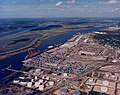 Port of Wilmington Aerial 3B19.jpg 450 × 358; 43 KB
-
 Progress on Parkway and Grandfather Mountain connection (11af1b9b5abd451a86b5039dd05fc4d7).tif 2,441 × 1,498; 10.46 MB
-
 Progress on Parkway and Grandfather Mountain connection (1ec91456fadc41569c76e2cd63d2839f).tif 2,390 × 1,497; 10.24 MB
-
 Progress on Parkway and Grandfather Mountain connection (1f1762ee7764496e9007a3c0e6b898ed).tif 2,412 × 1,503; 10.37 MB
-
 Progress on Parkway and Grandfather Mountain connection (505d232a24a6470393b4f110482a9057).tif 2,436 × 1,497; 10.43 MB
-
 Progress on Parkway and Grandfather Mountain connection (56c60fa8589a4f89bec88de2cfa7e373).tif 2,413 × 1,498; 10.34 MB
-
 Progress on Parkway and Grandfather Mountain connection (727e1bf719314764b2092d910fb70392).tif 2,413 × 1,498; 10.34 MB
-
 Progress on Parkway and Grandfather Mountain connection (847b742d44d54cd0be1398defe8d71fa).tif 2,431 × 1,497; 10.41 MB
-

-
 Progress on Parkway and Grandfather Mountain connection (93c6837344d74401addb6329e007177e).tif 2,415 × 1,497; 10.34 MB
-
 Progress on Parkway and Grandfather Mountain connection (db73d53e400d4fb18463a2725d96f3f7).tif 2,418 × 1,497; 10.36 MB
-
-
 Progress on Parkway and Grandfather Mountain connection (ea8dc7e83b4b4db594cf1ce90c074e2c).tif 2,416 × 1,500; 10.37 MB
-
 Rhodhiss Lake (North Carolina, USA) 4.jpg 4,000 × 3,000; 11.14 MB
-
 Rhodhiss Lake (North Carolina, USA) 5.jpg 4,000 × 3,000; 9.91 MB
-
 Ridgecrest Conference Center in Ridgecrest, North Carolina was established in 1907.jpg 4,032 × 3,024; 3.22 MB
-
 Spartanc111121.jpg 5,464 × 3,640; 1.85 MB
-
 Stone Mountain & Three Top Mountain (Tennessee-North Carolina, USA) 2.jpg 4,000 × 3,000; 10.06 MB
-
 The Macon County Courthouse in Franklin, North Carolina 02.jpg 3,411 × 2,558; 4.26 MB
-
 The modern Clay County Government Center and courthouse in Hayesville, North Carolina 01.jpg 10,446 × 7,836; 13.1 MB
-
 The modern Clay County Government Center and courthouse in Hayesville, North Carolina 02.jpg 4,406 × 5,874; 5.86 MB
-
 The modern Clay County Government Center and courthouse in Hayesville, North Carolina 03.jpg 4,441 × 2,669; 3.95 MB
-
 The modern Clay County Government Center and courthouse in Hayesville, North Carolina 04.jpg 7,776 × 4,098; 6.69 MB
-
 The Tri-County Community College campus in Peachtree, N.C.jpg 4,032 × 3,024; 12.64 MB
-
 The Tusquittee mountain range in Clay County, North Carolina.jpg 4,032 × 3,024; 8.92 MB
-
 Three Top Mountain (North Carolina, USA) 1.jpg 4,000 × 3,000; 10.08 MB
-
 Three Top Mountain (North Carolina, USA) 3.jpg 4,000 × 3,000; 8.75 MB
-
 Three Top Mountain (North Carolina, USA) 4.jpg 4,000 × 2,893; 8.93 MB
-
 Tomotla, North Carolina, a community in Cherokee County 01.jpg 4,032 × 3,024; 4.98 MB
-
 Tomotla, North Carolina, a community in Cherokee County 02.jpg 4,032 × 3,024; 5.05 MB
-
 Tomotla, North Carolina, a community in Cherokee County 03.jpg 4,032 × 3,024; 5.79 MB
-
 Tomotla, North Carolina, a community in Cherokee County 04.jpg 4,032 × 3,024; 5.04 MB
-
 View of New Hanover County from the Air (10 October 2023) 01.jpg 5,280 × 2,970; 8.52 MB
-
 View of New Hanover County from the Air (10 October 2023) 02.jpg 5,280 × 2,970; 9.4 MB
-
 View of New Hanover County from the Air (10 October 2023) 03.jpg 5,280 × 2,970; 11.98 MB
-
 View of New Hanover County from the Air (10 October 2023) 04.jpg 5,280 × 2,970; 11.32 MB
-
 View of New Hanover County from the Air (10 October 2023) 05.jpg 5,280 × 2,970; 10.66 MB
-
 View of New Hanover County from the Air (10 October 2023) 06.jpg 5,280 × 2,970; 9.84 MB
-
 View of New Hanover County from the Air (10 October 2023) 07.jpg 5,280 × 2,970; 12.04 MB
-
 View of New Hanover County from the Air (10 October 2023) 08.jpg 5,280 × 2,970; 9.26 MB
-
 View of New Hanover County from the Air (10 October 2023) 09.jpg 5,280 × 2,970; 7.49 MB
-
 View of New Hanover County from the Air (10 October 2023) 10.jpg 5,280 × 2,970; 7.71 MB
-
 View of New Hanover County from the Air (10 October 2023) 11.jpg 5,280 × 2,970; 7.61 MB
-
 View of New Hanover County from the Air (10 October 2023) 12.jpg 5,280 × 2,970; 14.03 MB
-
 View of New Hanover County from the Air (10 October 2023) 13.jpg 5,280 × 2,970; 12.77 MB
-
 View of New Hanover County from the Air (10 October 2023) 14.jpg 5,280 × 2,970; 12.68 MB
-
 View of New Hanover County from the Air (10 October 2023) 15.jpg 5,280 × 2,970; 10.57 MB
-
 View of New Hanover County from the Air (10 October 2023) 16.jpg 5,280 × 2,970; 11.57 MB
-
 View of New Hanover County from the Air (10 October 2023) 17.jpg 5,280 × 2,970; 11.63 MB
-
 View of New Hanover County from the Air (10 October 2023) 18.jpg 5,280 × 2,970; 12.09 MB
-
 View of New Hanover County from the Air (10 October 2023) 19.jpg 5,280 × 2,970; 10.95 MB
-
 View of New Hanover County from the Air (10 October 2023) 20.jpg 5,280 × 2,970; 8.48 MB
-
 View of New Hanover County from the Air (10 October 2023) 21.jpg 5,280 × 2,970; 8.52 MB
-
 View of New Hanover County from the Air (10 October 2023) 22.jpg 5,280 × 2,970; 8.84 MB
-
 View of New Hanover County from the Air (10 October 2023) 23.jpg 5,280 × 2,970; 9.66 MB
-
 View of New Hanover County from the Air (10 October 2023) 24.jpg 5,280 × 2,970; 11.86 MB
-
 View of New Hanover County from the Air (10 October 2023) 25.jpg 5,280 × 2,970; 10.23 MB
-
 View of New Hanover County from the Air (10 October 2023) 26.jpg 5,280 × 2,970; 11.31 MB
-
 View of New Hanover County from the Air (10 October 2023) 27.jpg 5,280 × 2,970; 10.63 MB
-
 View of New Hanover County from the Air (10 October 2023) 28.jpg 5,280 × 2,970; 12.48 MB
-
 View of New Hanover County from the Air (10 October 2023) 29.jpg 5,280 × 2,970; 11.47 MB
-
 View of New Hanover County from the Air (10 October 2023) 30.jpg 5,280 × 2,970; 10.96 MB
-
 View of New Hanover County from the Air (10 October 2023) 31.jpg 5,280 × 2,970; 11.25 MB
-
 View of New Hanover County from the Air (10 October 2023) 32.jpg 5,280 × 2,970; 10.57 MB
-
 View of New Hanover County from the Air (10 October 2023) 33.jpg 5,280 × 2,970; 11.2 MB
-
 View of New Hanover County from the Air (10 October 2023) 34.jpg 5,280 × 2,970; 11.05 MB
-
 View of New Hanover County from the Air (10 October 2023) 35.jpg 5,280 × 2,970; 10.56 MB
-
 View of New Hanover County from the Air (10 October 2023) 36.jpg 5,280 × 2,970; 11.73 MB
-
 View of New Hanover County from the Air (10 October 2023) 37.jpg 5,280 × 2,970; 11.33 MB
-
 View of New Hanover County from the Air (10 October 2023) 38.jpg 5,280 × 2,970; 11.97 MB
-
 View of North Carolina from the Air (August 2023) 01.jpg 6,000 × 4,000; 5.56 MB
-
 View of North Carolina from the Air (August 2023) 02.jpg 6,000 × 4,000; 5.45 MB
-
 View of North Carolina from the Air (August 2023) 03.jpg 6,000 × 4,000; 5.36 MB
-
 View of North Carolina from the Air (August 2023) 04.jpg 6,000 × 4,000; 4.54 MB
-
 View of North Carolina from the Air (August 2023) 05.jpg 6,000 × 4,000; 5.6 MB
-
 View of North Carolina from the Air (August 2023) 06.jpg 6,000 × 4,000; 5.59 MB
-
 View of North Carolina from the Air (August 2023) 07.jpg 6,000 × 4,000; 5.17 MB
-
 View of North Carolina from the Air (August 2023) 08.jpg 6,000 × 4,000; 5 MB
-
 View of North Carolina from the Air (August 2023) 09.jpg 6,000 × 4,000; 4.88 MB
-
 View of North Carolina from the Air (August 2023) 10.jpg 6,000 × 4,000; 5.51 MB
-
 View of North Carolina from the Air (August 2023) 11.jpg 6,000 × 4,000; 5.81 MB
-
 View of North Carolina from the Air (August 2023) 12.jpg 6,000 × 4,000; 5.67 MB
-
 View of North Carolina from the Air (August 2023) 13.jpg 6,000 × 4,000; 5.13 MB
-
 View of North Carolina from the Air (August 2023) 14.jpg 6,000 × 4,000; 9.69 MB
-
 View of North Carolina from the Air (August 2023) 15.jpg 6,000 × 4,000; 8.54 MB
-
 View of North Carolina from the Air (August 2023) 16.jpg 6,000 × 4,000; 8.75 MB
-
 View of North Carolina from the Air (August 2023) 17.jpg 6,000 × 4,000; 7.18 MB
-
 View of North Carolina from the Air (August 2023) 18.jpg 6,000 × 4,000; 5.53 MB
-
 View of North Carolina from the Air (December 2023).jpg 6,000 × 4,000; 6.74 MB
-
 View of North Carolina from the Air (July 2023) 01.jpg 6,000 × 4,000; 5.24 MB
-
 View of North Carolina from the Air (July 2023) 02.jpg 6,000 × 4,000; 6.72 MB
-
 View of North Carolina from the Air (July 2023) 03.jpg 6,000 × 4,000; 6.89 MB
-
 View of North Carolina from the Air (July 2023) 04 (cropped).jpg 4,651 × 2,126; 4.54 MB
-
 View of North Carolina from the Air (July 2023) 04.jpg 6,000 × 4,000; 8.24 MB
-
 View of North Carolina from the Air (July 2023) 05.jpg 6,000 × 4,000; 7.01 MB
-
 View of North Carolina from the Air (July 2023) 06.jpg 6,000 × 4,000; 6.31 MB
-
 View of North Carolina from the Air (July 2023) 07.jpg 6,000 × 4,000; 5.59 MB
-
 View of North Carolina from the Air (July 2023) 08.jpg 6,000 × 4,000; 6.76 MB
-
 View of North Carolina from the Air (July 2023) 09.jpg 6,000 × 4,000; 5.72 MB
-
 View of North Carolina from the Air (July 2023) 10.jpg 6,000 × 4,000; 4.93 MB
-
 View of North Carolina from the Air (July 2023) 11.jpg 6,000 × 4,000; 5.37 MB
-
 View of North Carolina from the Air (July 2023) 12.jpg 6,000 × 4,000; 4.98 MB
-
 View of North Carolina from the Air (July 2023) 13.jpg 6,000 × 4,000; 5.1 MB
-
 View of North Carolina from the Air (July 2023) 14.jpg 6,000 × 4,000; 5.79 MB
-
 View of North Carolina from the Air (July 2023) 15.jpg 6,000 × 4,000; 5.34 MB
-
 View of North Carolina from the Air (July 2023) 16.jpg 6,000 × 4,000; 5.91 MB
-
 View of North Carolina from the Air (July 2023) 17.jpg 6,000 × 4,000; 6.9 MB
-
 View of North Carolina from the Air (July 2023) 18.jpg 6,000 × 4,000; 7.14 MB
-
 View of North Carolina from the Air (July 2023) 19.jpg 6,000 × 4,000; 5.22 MB
-
 View of North Carolina from the Air (July 2023) 20.jpg 6,000 × 2,426; 1.69 MB
-
 View of North Carolina from the Air (October 2023) 01.jpg 6,000 × 4,000; 7.31 MB
-
 View of North Carolina from the Air (October 2023) 02.jpg 6,000 × 4,000; 8.25 MB
-
 View of North Carolina from the Air (October 2023) 03.jpg 6,000 × 4,000; 6.17 MB
-
 View of North Carolina from the Air (October 2023) 04.jpg 6,000 × 4,000; 9.31 MB
-
 View of North Carolina from the Air (October 2023) 05.jpg 6,000 × 4,000; 8.09 MB
-
 View of North Carolina from the Air (October 2023) 06.jpg 6,000 × 4,000; 6.99 MB
-
 View of North Carolina from the Air (October 2023) 07.jpg 6,000 × 4,000; 6.79 MB
-
 View of North Carolina from the Air (October 2023) 08.jpg 6,000 × 4,000; 13.45 MB
-
 View of North Carolina from the Air (October 2023) 09.jpg 6,000 × 4,000; 5.6 MB
-
 View of North Carolina from the Air (October 2023) 10.jpg 6,000 × 4,000; 5.98 MB
-
 View of North Carolina from the Air (October 2023) 11.jpg 6,000 × 4,000; 4.96 MB
-
 View of North Carolina from the Air (October 2023) 12.jpg 6,000 × 3,192; 1.55 MB
-
 View of North Carolina from the Air (October 2023) 13.jpg 6,000 × 3,150; 1.34 MB
-
 View of North Carolina from the Air (October 2023) 14.jpg 6,000 × 4,000; 5.34 MB
-
 View of North Carolina from the Air (October 2023) 15.jpg 6,000 × 2,853; 1.2 MB
-
 View of North Carolina from the Air (October 2023) 16.jpg 6,000 × 4,000; 5.08 MB
-
 View of North Carolina from the Air (October 2023) 17.jpg 6,000 × 2,846; 1.47 MB
-
 View of North Carolina from the Air (October 2023) 18.jpg 6,000 × 3,406; 1.82 MB
-
 View of North Carolina from the Air (October 2023) 19.jpg 6,000 × 4,000; 5.3 MB
-
 View of North Carolina from the Air (October 2023) 20.jpg 6,000 × 3,413; 1.87 MB
-
 View of North Carolina from the Air (October 2023) 21.jpg 6,000 × 4,000; 6.04 MB
-
 View of North Carolina from the Air (October 2023) 22.jpg 6,000 × 2,874; 1.63 MB
-
 View of North Carolina from the Air (October 2023) 23.jpg 6,000 × 3,751; 2.08 MB
-
 View of North Carolina from the Air (October 2023) 24.jpg 6,000 × 4,000; 6.24 MB
-
 View of North Carolina from the Air (October 2023) 25.jpg 6,000 × 3,323; 1.95 MB
-
 View of North Carolina from the Air (October 2023) 26.jpg 6,000 × 4,000; 5.27 MB
-
 View of North Carolina from the Air (October 2023) 27.jpg 6,000 × 4,000; 6.6 MB
-
 View of North Carolina from the Air (October 2023) 28.jpg 6,000 × 3,378; 1.95 MB
-
 View of North Carolina from the Air (October 2023) 29.jpg 6,000 × 4,000; 7.4 MB
-
 View of North Carolina from the Air (October 2023) 30.jpg 6,000 × 4,000; 6.57 MB
-
 View of North Carolina from the Air (October 2023) 31.jpg 6,000 × 4,000; 6.47 MB
-
 View of North Carolina from the Air (October 2023) 32.jpg 6,000 × 3,627; 2.02 MB
-
 WFBMC Aerial image.jpg 200 × 150; 18 KB
-
 WilmingtonAerialViewCoastGuard.jpg 1,020 × 696; 98 KB

.jpg)


_in_Andrews,_North_Carolina_and_Cherokee_County.jpg)


.jpg)


.jpg)

.jpg)

.jpg)
.jpg)


.jpg)

_4.jpg)
_5.jpg)


_2.jpg)


_1.jpg)
_3.jpg)
_4.jpg)


_01.jpg)
_02.jpg)
_03.jpg)
_04.jpg)
_05.jpg)
_06.jpg)
_07.jpg)
_08.jpg)
_09.jpg)
_10.jpg)
_11.jpg)
_12.jpg)
_13.jpg)
_14.jpg)
_15.jpg)
_16.jpg)
_17.jpg)
_18.jpg)
_19.jpg)
_20.jpg)
_21.jpg)
_22.jpg)
_23.jpg)
_24.jpg)
_25.jpg)
_26.jpg)
_27.jpg)
_28.jpg)
_29.jpg)
_30.jpg)
_31.jpg)
_32.jpg)
_33.jpg)
_34.jpg)
_35.jpg)
_36.jpg)
_37.jpg)
_38.jpg)
_01.jpg)
_02.jpg)
_03.jpg)
_04.jpg)
_05.jpg)
_06.jpg)
_07.jpg)
_08.jpg)
_09.jpg)
_10.jpg)
_11.jpg)
_12.jpg)
_13.jpg)
_14.jpg)
_15.jpg)
_16.jpg)
_17.jpg)
_18.jpg)
.jpg)
_01.jpg)
_02.jpg)
_03.jpg)
_04_(cropped).jpg)
_04.jpg)
_05.jpg)
_06.jpg)
_07.jpg)
_08.jpg)
_09.jpg)
_10.jpg)
_11.jpg)
_12.jpg)
_13.jpg)
_14.jpg)
_15.jpg)
_16.jpg)
_17.jpg)
_18.jpg)
_19.jpg)
_01.jpg)
_02.jpg)
_03.jpg)
_04.jpg)
_05.jpg)
_06.jpg)
_07.jpg)
_08.jpg)
_09.jpg)
_10.jpg)
_11.jpg)
_12.jpg)
_13.jpg)
_14.jpg)
_15.jpg)
_16.jpg)
_17.jpg)
_18.jpg)
_19.jpg)
_20.jpg)
_21.jpg)
_22.jpg)
_23.jpg)
_24.jpg)
_25.jpg)
_26.jpg)
_27.jpg)
_28.jpg)
_29.jpg)
_30.jpg)
_31.jpg)
_32.jpg)


_20.jpg)