Category:20th-century maps of Moravia
Jump to navigation
Jump to search
Media in category "20th-century maps of Moravia"
The following 15 files are in this category, out of 15 total.
-
 Brünn - 34-49.jpg 3,360 × 4,949; 4.61 MB
-
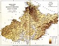
 Geological map of Moravia and Austrian Silesia.jpg 2,144 × 1,646; 1.67 MB
-
 Geologie Moravy.jpg 2,092 × 213; 184 KB
-
 Iglau - 33-49.jpg 3,340 × 4,958; 4.44 MB
-
 Josefstadt - 34-50.jpg 3,264 × 5,023; 3.7 MB
-
 Lundenburg - 35-49.jpg 3,326 × 4,957; 4.66 MB
-
 Map of Moravia and Austrian Silesia 2.jpg 2,211 × 1,717; 2.22 MB
-
 Map of Moravia and Austrian Silesia.jpg 2,133 × 1,669; 1.75 MB
-
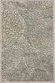
 Map of Moravia.jpg 6,406 × 4,722; 18.47 MB
-
 Mapa Moravy 2.jpg 6,614 × 4,677; 7.78 MB
-
 Mapa zemí československých.jpg 1,111 × 813; 1.11 MB
-
 Olmütz - 35-50.jpg 3,272 × 4,973; 4.65 MB
-
 Trentschin - 36-49.jpg 3,360 × 4,956; 4.83 MB
-
 Troppau - 36-50.jpg 3,302 × 4,979; 4.57 MB
-
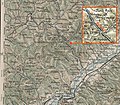 Wlarapass.jpg 1,375 × 1,205; 1.82 MB


