Category:1940s maps of England
Jump to navigation
Jump to search
Constituent countries of the United Kingdom: England
Subcategories
This category has the following 2 subcategories, out of 2 total.
Media in category "1940s maps of England"
The following 22 files are in this category, out of 22 total.
-
 20th Century Map of Beetley.png 871 × 553; 1.02 MB
-
 20th Century map of Carlton.PNG 395 × 310; 352 KB
-
 Cliffe and Cliffe Woods area historical map.png 349 × 466; 306 KB
-
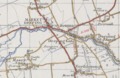 Historical map showing Deeping Gate.PNG 581 × 380; 455 KB
-

-
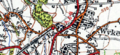 Wyke and Norwood Green station from OS map 1945.png 682 × 312; 458 KB
-
 Foxley Herefordshire SO44 - OS 125,000 Provisional Series Map 1956.jpg 1,654 × 1,050; 1.33 MB
-
 20th Century Little Torrington Map.PNG 451 × 421; 523 KB
-
 A1528793h.jpg 748 × 1,050; 645 KB
-
 Area surrounding Tingrith Civil Parish, Central Bedfordshire.png 1,101 × 565; 1.52 MB
-
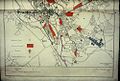
 Barking1945.png 700 × 481; 66 KB
-
 Bodleian Libraries, City of Oxford, 19401941, lower half of map.jpg 1,000 × 675; 145 KB
-
 Bodleian Libraries, City of Oxford, 19401941, upper half of map.jpg 1,000 × 675; 152 KB
-
 Canterbury Orchards 1945 OS Map 171 detail.jpg 2,890 × 1,996; 2.7 MB
-
 Ordnance Survey Map from the 20th century of Ashleyhay, Derbyshire.png 1,102 × 648; 1.44 MB
-
 Ordnance Survey One-Inch Sheet 123 Spalding, Published 1946.jpg 10,924 × 12,746; 14.15 MB
-
 Ordnance Survey One-Inch Sheet 134 Huntingdon & Peterborough, Published 1946.jpg 10,967 × 12,765; 14.72 MB
-
 Ordnance Survey One-Inch Sheet 173 East Kent, Published 1945.jpg 10,987 × 12,763; 14.79 MB
-
 Ordnance Survey One-Inch Sheet 180 The Solent, Published 1945.jpg 8,163 × 9,570; 10.68 MB
-
 OS Rye 1945.png 777 × 450; 735 KB
-
 Southampton road map 1948.jpg 2,560 × 2,432; 671 KB
-
 Thurrock1945.png 700 × 481; 66 KB


