Category:1890s maps of Hamburg
Jump to navigation
Jump to search
|
Federal states of Germany: |
Subcategories
This category has the following 5 subcategories, out of 5 total.
- 1890 maps of Hamburg (17 F)
- 1891 maps of Hamburg (empty)
- 1892 maps of Hamburg (1 F)
- 1897 maps of Hamburg (3 F)
- 1898 maps of Hamburg (2 F)
Media in category "1890s maps of Hamburg"
The following 6 files are in this category, out of 6 total.
-
 Meyers leiner Hand-atlas 1893 (73136693).jpg 9,521 × 6,398; 11.13 MB
-

-
 441 of 'Neumanns Orts-Lexikon des Deutschen Reichs' (11229374685).jpg 4,824 × 2,696; 3.7 MB
-
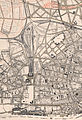 Altona Bf 1894 Ausschnitt.jpg 3,951 × 5,786; 5.13 MB
-
 Der Hafen von Hamburg 1 - 10.000 - von M. Bucheister... - btv1b53121309m.jpg 8,986 × 4,544; 5.75 MB
-
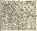 Karte des Deutschen Reiches - Composite 178, Harburg, 5820178c.jpg 10,948 × 9,263; 29.56 MB
.jpg)
.jpg)
.jpg)


