Category:1880s maps of Finland
Jump to navigation
Jump to search
Countries of Europe: Armenia‡ · Azerbaijan‡ · Belgium · Bosnia and Herzegovina · Bulgaria · Croatia · Cyprus‡ · Czech Republic · Denmark · Estonia · Finland · France‡ · Georgia‡ · Germany · Greece · Hungary · Iceland · Republic of Ireland · Italy · Latvia · Lithuania · Montenegro · Netherlands‡ · Norway · Poland · Portugal‡ · Romania · Russia‡ · Serbia · Slovakia · Slovenia · Spain‡ · Sweden · Switzerland · Turkey‡ · Ukraine · United Kingdom
Limited recognition: Abkhazia‡
‡: partly located in Europe
Limited recognition: Abkhazia‡
‡: partly located in Europe
Subcategories
This category has the following 2 subcategories, out of 2 total.
- 1889 maps of Finland (1 F)
Media in category "1880s maps of Finland"
The following 7 files are in this category, out of 7 total.
-
 39298274 Topografinen kartta, vuosi tuntematon, mv, III20.jpg 4,519 × 4,154; 2.99 MB
-
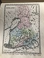
 HAZELIUS(1881) Vol.1, p187 Karta.jpg 2,173 × 3,370; 3.83 MB
-
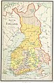
 1881 «SUOMENMAANKARTTA».jpg 8,268 × 14,234; 12.8 MB
-

-
 Päijänne 1883.jpg 927 × 1,200; 140 KB
-
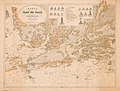 Suomen rannikkoa 1880.jpg 1,200 × 912; 156 KB
-
 XX 15 c. Finland.jpg 3,024 × 4,032; 3.21 MB

_Vol.1,_p187_Karta.jpg)

.jpg)


