Category:1859 maps of Massachusetts
Jump to navigation
Jump to search
States of the United States: California · Florida · Massachusetts · Michigan · New York · Oregon · Texas – Washington, D.C.
| ← 1850 1851 1852 1853 1854 1855 1856 1857 1858 1859 → |
Media in category "1859 maps of Massachusetts"
The following 9 files are in this category, out of 9 total.
-

-
 1859 NorthSt Boston map.jpg 2,000 × 782; 1.17 MB
-
 1859 Plan of Boston comprising a part of Charlestown and Cambridge (2674457079).jpg 1,627 × 2,000; 3.33 MB
-

-
-
 A Map of the town of Shrewsbury, Mass. (3719858137).jpg 773 × 1,024; 619 KB
-
 Map of Boston and its vicinity (2675741606).jpg 2,000 × 1,801; 3.04 MB
-

-

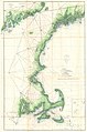
,_Massachusetts_-_Geographicus_-_MuskegetChannel2-uscs-1859.jpg)
.jpg)


.jpg)
.jpg)
.jpg)
.jpg)