Category:1855 maps of Massachusetts
Jump to navigation
Jump to search
States of the United States: California · Connecticut · Florida · Illinois · Louisiana · Massachusetts · Missouri · New Mexico · New York · Ohio · Oregon · Pennsylvania · Rhode Island · Texas · Utah · Vermont · Washington – Washington, D.C.
| ← 1850 1851 1852 1853 1854 1855 1856 1857 1858 1859 → |
Media in category "1855 maps of Massachusetts"
The following 24 files are in this category, out of 24 total.
-
 1855 Boston and Lowell Railroad map.jpg 4,660 × 8,562; 12.77 MB
-
 1855 Colton Map of Massachusetts and Rhode Island - Geographicus - MA-colton-1855.jpg 4,000 × 3,264; 3.2 MB
-

-
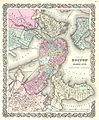 1855 Colton Plan or Map of Boston - Geographicus - Boston-colton-1855.jpg 3,290 × 4,000; 3.9 MB
-
 Map of Hampden County, Massachusetts LOC 2012592412.jpg 20,440 × 13,657; 41.24 MB
-
 Map of the town of Canton, Norfolk County, Mass. (3855699027).jpg 1,594 × 2,000; 2.73 MB
-
 Map of the town of Easton, Bristol County, Massachusetts (2674190301).jpg 1,452 × 2,000; 2.61 MB
-
 Map of the town of Fairhaven, Bristol County, Mass. (3856489454).jpg 1,380 × 2,000; 2.54 MB
-
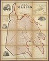 Map of the town of Marion, Plymouth County, Mass. (3370522090).jpg 1,604 × 2,000; 3.33 MB
-
 Map of the town of Medford, Middlesex County, Mass. (3856489816).jpg 1,899 × 2,000; 3.39 MB
-
 Map of the town of Middleborough, Plymouth County, Mass. (3370521812).jpg 1,844 × 2,000; 4.05 MB
-
 Map of the town of Norton, Bristol County, Mass. (3855702303).jpg 2,000 × 1,662; 2.81 MB
-
 Map of the town of Petersham, Worcester County, Massachusetts. LOC 76697521.jpg 14,596 × 9,622; 19.46 MB
-
 Map of the town of Petersham, Worcester County, Massachusetts. LOC 76697521.tif 14,596 × 9,622; 401.81 MB
-
 Map of the town of Pittsfield, Berkshire County, Mass. LOC gm70002591.jpg 13,231 × 17,315; 34.63 MB
-
 Map of the town of Raynham, Bristol County, Mass. (3720673082).jpg 811 × 1,024; 707 KB
-
 Massachusetts map, 1855, taken from an unknown geography book.jpg 6,252 × 3,733; 13.5 MB
-

-
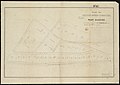
 Plan of (Boston) Public Library lot (9138718272).jpg 799 × 576; 53 KB
-
 Plan of Boston comprising a part of Charlestown and Cambridge (2674446357).jpg 1,815 × 2,000; 3.29 MB
-
 Plan of dwelling houses & house lots, in West Roxbury (2675566546).jpg 2,000 × 1,420; 2.07 MB
-

-

-
 Plan of lands belonging to the Boston Water Power Company (3120132377).jpg 2,000 × 1,584; 2.71 MB


.jpg)
.jpg)
.jpg)
.jpg)
.jpg)
.jpg)
.jpg)


.jpg)

.jpg)
_Public_Library_lot_(9138718272).jpg)
.jpg)
.jpg)
.jpg)
.jpg)
.jpg)