Category:1857 maps of Florida
Jump to navigation
Jump to search
States of the United States: California · Florida · Illinois · Massachusetts · New Mexico · New York · Ohio · Pennsylvania · Texas · Utah · Vermont
| ← 1852 1853 1855 1856 1857 1859 → |
Media in category "1857 maps of Florida"
The following 7 files are in this category, out of 7 total.
-
 1857 U.S. Coast Survey Map of Florida - Geographicus - FloridaFVI-uscs-1857.jpg 3,551 × 4,000; 2.54 MB
-
-

-

-
 Map of the State of Florida Showing the Progress of the Surveys - NARA - 25464183.jpg 8,416 × 9,312; 5.16 MB
-
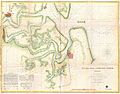
 Preliminary chart of the entrance to Pensacola Bay, Florida. LOC 78692126.jpg 9,674 × 8,300; 10.99 MB
-
 Preliminary chart of the entrance to Pensacola Bay, Florida. LOC 78692126.tif 9,674 × 8,300; 229.72 MB


