Category:1776 maps of New York (state)
Jump to navigation
Jump to search
States of the United States: Delaware · Massachusetts · New Jersey · New York · Pennsylvania · Virginia
Media in category "1776 maps of New York (state)"
The following 46 files are in this category, out of 46 total.
-
 (A Plan of the city of New York. LOC gm71000646.jpg 5,208 × 6,468; 4.9 MB
-
 (New York Island. Military; unfinished. LOC gm71002309.jpg 3,341 × 5,066; 1.89 MB
-

-
 1776mcgowansmap.jpg 400 × 726; 46 KB
-

-

-

-

-

-

-

-

-

-

-
 A plan of the city and environs of New York in North America. LOC 2002623929.jpg 3,792 × 3,207; 2.19 MB
-
 A plan of the city and environs of New York in North America. LOC 2002623929.tif 3,792 × 3,207; 34.79 MB
-
 A Plan of the city and environs of New York in North America. NYPL434407.tiff 4,886 × 5,610; 78.42 MB
-
 A Plan of the city and environs of New York in North America. NYPL483720.tiff 4,896 × 5,475; 76.7 MB
-

-

-

-
 Battle of Long Island (crop).jpg 974 × 695; 126 KB
-
 Battle of Long Island, 1776 - ru.svg 919 × 1,041; 508 KB
-
 Hudson River Chart 1776.jpg 7,560 × 9,958; 12.29 MB
-

-
 Long Island 1776 (2).png 509 × 521; 810 KB
-
 Map of Brooklyn and Lower Manhattan in September 1776 (4 MB).jpg 2,559 × 1,818; 3.48 MB
-
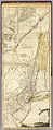 New York and New Jersey 1776.jpg 3,563 × 8,688; 6.51 MB
-
 NYC1776 crop.jpg 2,706 × 2,545; 4.65 MB
-
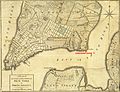 NYC1776 labelled.jpg 4,360 × 3,360; 7.88 MB
-
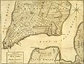 NYC1776.jpg 4,360 × 3,360; 6.9 MB
-

-
-
 The country twenty five miles round New York (NYPL b14917381-434397).jpg 4,041 × 4,847; 4.16 MB
-
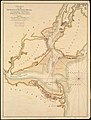
 Sketch of New York, narrows & part of Long Island with the roads. LOC 73691874.jpg 6,184 × 11,183; 6.49 MB
-
 Sketch of the country illustrating the late engagement in Long Island (4578775159).jpg 4,396 × 2,484; 4.45 MB
-

-

-

-

-

-

-

-

-
 Vie de George Washington 1807 (125491516).jpg 4,857 × 7,422; 8.58 MB
-
 Vie de George Washington 1807 (125491521).jpg 4,840 × 7,413; 7.96 MB


_hung_on_a_horn%27_(11209900936).jpg)


.jpg)


.png)
.jpg)


.jpg)
.jpg)
.jpg)

.jpg)

.jpg)
.jpg)