Category:1776 maps of Massachusetts
Jump to navigation
Jump to search
States of the United States: Delaware · Massachusetts · New Jersey · New York · Pennsylvania · Virginia
| ← 1770 1772 1774 1775 1776 1777 1778 1779 → |
Media in category "1776 maps of Massachusetts"
The following 35 files are in this category, out of 35 total.
-
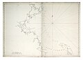
 (A chart of Boston Bay and vicinity. LOC 77693975.jpg 12,600 × 8,992; 12.3 MB
-

-

-
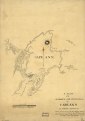
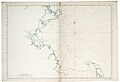
 A plan of the harbour and peninsula of Cape Ann in North America, LOC gm71005447.jpg 3,329 × 4,719; 1.65 MB
-
 A plan of the harbour and peninsula of Cape Ann in North America, LOC gm71005447.tif 3,329 × 4,719; 44.95 MB
-
 Boston Bay Nautical Chart 1776.jpg 10,751 × 7,677; 12.34 MB
-
 Boston Bay RMG K0727.jpg 1,280 × 932; 732 KB
-
 Boston Bay RMG K0728.jpg 1,280 × 912; 679 KB
-
 Boston Bay RMG K0729.jpg 1,280 × 893; 707 KB
-
 Boston Bay RMG K0730.jpg 1,280 × 904; 702 KB
-
 Boston Bay RMG K0731.jpg 1,280 × 928; 680 KB
-
 Boston Bay RMG K0732.jpg 1,280 × 898; 669 KB
-
 Buzzards Bay and Vineyard Sound (3046534646).jpg 1,394 × 2,000; 2.29 MB
-
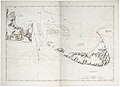
 Chart of Buzzards Bay and Vineyard Sound. LOC 77692979.jpg 8,886 × 12,539; 12.57 MB
-
 Chart of Buzzards Bay and Vineyard Sound. LOC 77692979.tif 8,886 × 12,539; 318.78 MB
-
 Chart of Buzzards Bay and Vineyard Sound. LOC 77693977.jpg 9,825 × 13,659; 18.1 MB
-
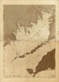 Chart of Buzzards Bay and Vineyard Sound. LOC 77693977.tif 9,825 × 13,659; 383.95 MB
-
 Chart of Nantucket Island and the eastern half of Martha's Vineyard. LOC 78692798.jpg 12,738 × 8,947; 12.49 MB
-
 Chart of Nantucket Island and the eastern half of Martha's Vineyard. LOC 78692798.tif 12,738 × 8,947; 326.06 MB
-
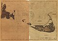 Chart of Nantucket Island and the eastern half of Martha's Vineyard. LOC 78692799.jpg 12,889 × 9,119; 12.83 MB
-
 Chart of Nantucket Island and the eastern half of Martha's Vineyard. LOC 78692799.tif 12,889 × 9,119; 336.27 MB
-

-

-
 Massachusetts Bay RMG K0720.jpg 1,280 × 931; 655 KB
-
 Massachusetts Bay RMG K0721.jpg 1,280 × 938; 719 KB
-
 Massachusetts Bay RMG K0722.jpg 1,280 × 880; 661 KB
-
 Massachusetts Bay RMG K0723.jpg 1,280 × 931; 669 KB
-
 Massachusetts Bay RMG K0724.jpg 1,280 × 912; 614 KB
-
 Massachusetts Bay RMG K0725.jpg 1,280 × 911; 694 KB
-
 Nantucket Island and the west end of Martha's Vineyard RMG K0712.jpg 1,280 × 930; 707 KB
-
 Nantucket Island and the west end of Martha's Vineyard RMG K0713.jpg 1,280 × 903; 701 KB
-
 Nantucket Island and the west end of Martha's Vineyard RMG K0714.jpg 1,280 × 931; 753 KB
-
 Nantucket Island and the west end of Martha's Vineyard RMG K0715.jpg 1,280 × 908; 805 KB
-
 Nantucket Island and the west end of Martha's Vineyard RMG K0716.jpg 1,280 × 900; 812 KB
-
 Nantucket Island and the west end of Martha's Vineyard RMG K0717.jpg 1,280 × 932; 811 KB


.jpg)


.jpg)
.jpg)


