Category:1770s maps of Chile
Jump to navigation
Jump to search
Countries of the Americas: Argentina · The Bahamas · Bolivia · Brazil · Canada · Chile · Colombia · Cuba · Ecuador · Mexico · Paraguay · Peru · Saint Vincent and the Grenadines · United States of America · Uruguay · Venezuela
Other areas: Aruba · Puerto Rico
Other areas: Aruba · Puerto Rico
Media in category "1770s maps of Chile"
The following 12 files are in this category, out of 12 total.
-

-
 Il Chile, regno dell'America meridionale - btv1b8441204t.jpg 7,138 × 5,712; 5.94 MB
-
 Mapa Chile Españoles y Araucanos.jpg 1,200 × 1,645; 400 KB
-
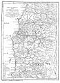
 Olmedilla.jpg 400 × 385; 40 KB
-
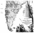
 Olmedilla1775.jpg 570 × 691; 81 KB
-

-

-
 Plano De Los Ferro-Carriles I Salitreras De La Provincia Litoral De Tarapacá.jpg 9,200 × 6,432; 11.25 MB
-
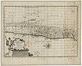
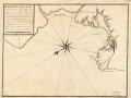
 Plano de Valparayzo LOC 90682633.jpg 5,777 × 4,350; 2.28 MB
-
 Plano de Valparayzo LOC 90682633.tif 5,777 × 4,350; 71.9 MB
-
 Provincia de Cuyo, Reino de Chile según Juan de la Cruz Cano y Olmedilla, 1775.jpg 1,171 × 1,798; 2.09 MB
-
 Reino de Chile según Juan de la Cruz Cano y Olmedilla, 1775.jpg 6,009 × 7,925; 38.79 MB


_Thenerife_LOC_90682665.jpg)


