Category:1720s maps of the Caribbean
Jump to navigation
Jump to search
Media in category "1720s maps of the Caribbean"
The following 16 files are in this category, out of 16 total.
-
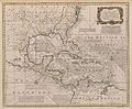 1720 Map of the West Indies with the Adjacent Coasts of North and South America (Bowen).jpg 9,010 × 7,447; 15.36 MB
-

-

-

-
 Frezier Map of S. Domingue.png 2,273 × 1,713; 5.24 MB
-

-
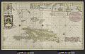
 Mapa Caribe 1720.jpg 2,820 × 2,332; 4.69 MB
-
 Nieuwe en Naaukeurige Paskaart van het Eyland Hispaniola of St. Domingo. NYPL2020761.tiff 9,251 × 5,921; 156.74 MB
-

-

-
-

-

-

-
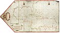
 Terra Firma and the Caribbé Islands &c. (6093636207).jpg 1,321 × 2,000; 2.59 MB
-
 UB Utrecht - Pieter Mortier - 1727 - Archipelague du Mexique.jpg 3,440 × 2,116; 5.52 MB
.jpg)


_Les_Forces_de_l%27Europe,_Asie,_Afrique_et_Amerique_Comme_aussi_les_Cartes_de,_RP-P-OB-83.036-257.jpg)


.jpg)

.jpg)
.jpg)
