User talk:Milenioscuro/Archive2
 | This is an archive of past discussions. Do not edit the contents of this page. If you wish to start a new discussion or revive an old one, please do so on the current talk page. |
You can leave your comments or suggestions here (in Spanish or English) or on my main account
Shadowxfox
in the Spanish Wikipedia

|
Our first steps tour and our frequently asked questions will help you a lot after registration. They explain how to customize the interface (for example the language), how to upload files and our basic licensing policy (Wikimedia Commons only accepts free content). You don't need technical skills in order to contribute here. Be bold when contributing and assume good faith when interacting with others. This is a wiki. More information is available at the community portal. You may ask questions at the help desk, village pump or on IRC channel #wikimedia-commons (webchat). You can also contact an administrator on their talk page. If you have a specific copyright question, ask at the copyright village pump. |
|
SieBot 06:31, 2 August 2007 (UTC)
|
|

.svg)
.svg)
.svg)
.svg)
.svg)
.svg)
.svg)
.svg)
Editor @ ar.wiki
Hello. I would like to inform you that I have granted you editor flag at the Arabic Wikipedia, all your edits there will be automatically marked as patrolled. Best regards.--Avocato (talk) 07:29, 6 December 2013 (UTC)
Colombia location map
Hello Shadowxfox, you changed the borders of the location map how ever the corresponding relief map, File:Colombia relief location map.jpg, remained with the previous coordinate borders. This causes a problem with location map templates when you want to use relief map, because the borders are not correct. If you can update the relief map accordingly or ask the relief map creator to update it. thanks, GilCahana (talk) 11:39, 28 January 2014 (UTC)
![]() Done
Done
Banderas
Disculpa la tardanza.
No entiendo eso de cambiarle el tipo de letra, hasta donde se nunca queda a la vista en los artículos y hasta donde se WK debe estar basado en Windows NT por lo que no distingue entre Mayúsculas o minúsculas, pero si la norma así lo dice adelante.
Saludos --Sarumo74 (talk) 08:39, 12 March 2014 (UTC)
![]() Answered
Answered

|
File:Mapa A2 Fallo Litigio Nicaragua - Colombia.svg has been listed at Commons:Deletion requests so that the community can discuss whether it should be kept or not. We would appreciate it if you could go to voice your opinion about this at its entry.
If you created this file, please note that the fact that it has been proposed for deletion does not necessarily mean that we do not value your kind contribution. It simply means that one person believes that there is some specific problem with it, such as a copyright issue. Please see Commons:But it's my own work! for a guide on how to address these issues. |
Yann (talk) 16:33, 7 April 2014 (UTC)
|
|
File:Mapa B2 Fallo Litigio Nicaragua - Colombia.svg has been listed at Commons:Deletion requests so that the community can discuss whether it should be kept or not. We would appreciate it if you could go to voice your opinion about this at its entry.
If you created this file, please note that the fact that it has been proposed for deletion does not necessarily mean that we do not value your kind contribution. It simply means that one person believes that there is some specific problem with it, such as a copyright issue. Please see Commons:But it's my own work! for a guide on how to address these issues. |
Yann (talk) 16:33, 7 April 2014 (UTC)
Hola Shadowxfox
Hola Shadowxfox, esta tarde que estuve desocupado logré seguir modificando el mapa que ya te había mencionado y logré el siguiente resultado: El mapa del mar de Grau, me gustaría que le des un vistazo y veas si la licencia está correcta, las categorías, etc. Si crees que debe ser modificado en algo el propio mapa, tienes la total libertad para hacerlo. También te quería comentar acerca de este mapa, y es que cuando estuve colaborando el artículo sobre las fronteras de Ecuador noté que este mapa esta desactualizado, te explico la versión original del mapa fue hecho en el 21 de mayo 2011 y en esa fecha aún Ecuador reclamaba un mar territorial de 200 millas, pero en el 2012 este país se adhirió a la Convemar y declaró formalmente que reconoce las zonas marítimas que señala esta convesión, es decir que reconoce un mar territorial de 12 millas y una zona económica hasta una distancia de 200 millas, te dejo este link de la Declaración realizada por el Ecuador al momento de la Adhesión, este documento lo puedes encontrar en la propia página web de la cancillería ecuatoriana. Saludos --Edubucher (talk) 03:26, 9 April 2014 (UTC)
![]() Done
Done
¡Qué útil aporte!
Entre los muchos buenos que has hecho. Creeme que los habitantes los antiguos territorios del Virreinato del Río de la Plata, por más que lo estudien en la educación inicial, no siempre recuerdan que estos una vez fueron parte del Virreinato del Perú. Un abrazo.--Fixertool (talk) 22:45, 10 April 2014 (UTC)
![]() Answered
Answered
|
|
File:Escudo Episcopado de Colombia.svg has been listed at Commons:Deletion requests so that the community can discuss whether it should be kept or not. We would appreciate it if you could go to voice your opinion about this at its entry.
If you created this file, please note that the fact that it has been proposed for deletion does not necessarily mean that we do not value your kind contribution. It simply means that one person believes that there is some specific problem with it, such as a copyright issue. Please see Commons:But it's my own work! for a guide on how to address these issues. |
181.48.189.109 12:43, 28 May 2014 (UTC)
.svg)
|
|
File:Flag of Santuario (Risaralda).svg has been listed at Commons:Deletion requests so that the community can discuss whether it should be kept or not. We would appreciate it if you could go to voice your opinion about this at its entry.
If you created this file, please note that the fact that it has been proposed for deletion does not necessarily mean that we do not value your kind contribution. It simply means that one person believes that there is some specific problem with it, such as a copyright issue. Please see Commons:But it's my own work! for a guide on how to address these issues. |
.svg)
Hosmich (talk) 15:18, 3 June 2014 (UTC)
.svg)
Location maps of India
Hello Shadowxfox. I saw you made in the past few location maps of India. Would you please prepare those missing? Carlos (talk) 09:18, 30 June 2014 (UTC)
- Thanks for your reply .. I have patience, and I'm waiting .. Carlos (talk) 22:01, 2 July 2014 (UTC)
- I saw the maps you made, You are great! Could you please prepare the remaining four? (Himachal Pradesh, Tripura, Mizoram and Lakshadweep) Carlos (talk) 19:47, 28 August 2014 (UTC)
![]() Done
Done
Guiana Shield Map Credit to Smithsonian
Please credit the Guiana Shield Map you make available to: Biological Diversity of the Guiana Shield Program, National Museum of Natural History, Smithsonian Institution.
- See: http://botany.si.edu/bdg/
- Particularly http://botany.si.edu/bdg/images/shieldlg.jpg
I helped create this map when I was a member of the Smithsonian BDG Program. We want our products to be freely available to people, but we do want the proper credit given.
Many Thanks, Tom Hollowell, NMNH Informatics
- Done. --Shadowxfox (talk) 19:23, 1 July 2014 (UTC)
 Resolved
|
|
File:Escudo Episcopado de Colombia.svg has been listed at Commons:Deletion requests so that the community can discuss whether it should be kept or not. We would appreciate it if you could go to voice your opinion about this at its entry.
If you created this file, please note that the fact that it has been proposed for deletion does not necessarily mean that we do not value your kind contribution. It simply means that one person believes that there is some specific problem with it, such as a copyright issue. Please see Commons:But it's my own work! for a guide on how to address these issues. |
190.242.99.162 12:31, 4 August 2014 (UTC)
Using a modified map in a publication
Do you have any objection if your maps are used (and significantly modified) in a publication? If you would like to be cited, we would be happy to do so, but the publisher requires that it be under an actual name, not a user name. Please let me know your preferences: dolezal@american.edu
![]() Answered
Answered
Sobre este archivo
Hola Shadowxfox, vengo a solicitarte la modificación de este artículo en lo que se refiere a inclusión de la zona en reclamación Guayana Esequiba. De facto y de iure los mismos pertenecen a Guayana y aunque la reclamación existe y en todos los mapas realizados en Venezuela aparece así, constituye un sesgo no neutral para Wikipedia. Por supuesto, esta discusión se ha llevado en varios artículos y con varios mapas que ya han sido modificados, este escapo de esa discusión en su momento. Agradecido --Oscar_. (talk) 22:10, 13 August 2014 (UTC)
- Evidentemente hablo de retirar la franja, no se porque se dio para malinterpretaciones mi primer mensaje, no busco cambiar todos los mapas de Commons, pero este en específico se utiliza para miles de localidades y me pareció importante mencionar el error. Saludos --Oscar_. (talk) 12:53, 14 August 2014 (UTC)
hola buena noche.
oye estuve mirando tu pagina muy buena, excelente trabajo. mira necesito uno de los mapas que tienes, (el geografico de colombia) para un trabajo de la universidad, estuve mirando y no supe como descargarlo. si me lo puedes compartir estaria muy agradecido!
RSFSR map
Dear Shadowxfox,
Would you please correct the map https://commons.wikimedia.org/wiki/File:Soviet_Union_-_Russian_SFSR_(before_1936_territorial_changes).svg. Turkmen SSR and Uzbek SSR (including Tajik ASSR) were separate republics since 1924. Before that, Bukhara and Khiva peoples' republics existed, which were not parts of Russian SFSR either. RSFSR has never existed in the outlines designated on this map.
Thank you in advance. — 188.162.65.7 15:36, 23 December 2014 (UTC)
.svg)
- See File talk:Soviet Union - Russian SFSR (1922).svg for details as to the mess you've made, and how it's affecting all articles using the map. This is urgent. Thank you for your co-operation. --Iryna Harpy (talk) 05:15, 26 December 2014 (UTC)
- Thank you for your hard work... and wishing you a Happy New Year! --Iryna Harpy (talk) 22:03, 3 January 2015 (UTC)
.svg)
AM de Colombia
Gracias por subir archivos a commons ,pero mi observacion está en el nombre, no será mejor que solo este en el mapa el nombre de las localidades, sin el titulo ?,se ve mejor ya el nombre lo lleva el art ,ademas se vería mejor para otros idiomas sin necesidad de estar haciendo mas mapas. Category:Maps of metropolitan areas in Colombia. --EEIM (talk) 01:15, 2 January 2015 (UTC)
![]() Answered
Answered
Socotra no es Somalia
Hola,
A cambiado la categoria de la mapa en occitano de Socotra a "Topographic map of Somalia" pero Socotra no es Somalia, sino Yemen.
Gracias por anular el cambio.
Muy atentamente.
--Jfblanc (talk) 13:19, 17 January 2015 (UTC)
![]() Done
Done
Maps about Territorial changes of Russian SFSR
Hola
U make many new maps about about Territorial changes of Russian SFSR, for example: 1922, 1924, 1929, 1936, 1940.
.svg)
.svg)
.svg)
.svg)
.svg)
Can u make one more map for year 1945?
p.s. here is Russian article about territorial changes.--Gaga.vaa (talk) 08:28, 5 February 2015 (UTC)
![]() Done
Done
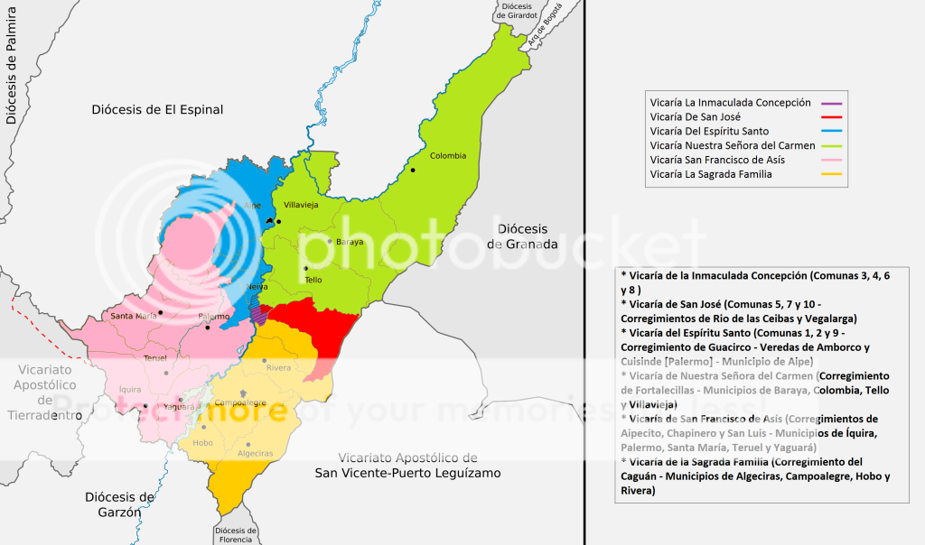
Mapa Diócesis de Neiva
Hola buen día, estuve mirando que hace falta un mapa adicional en la Diócesis de Neiva y es sobre la jurisdicción de las Vicarías, hice un mapa borrador imitando la Arquidiócesis de Medellín y sus Vicarías, (ver aquí) pero me gustaría que tu lo editaras con tu formato para este tipo de mapas. Cualquier inquietud no dudes en hacermela saber. Gracias.--Seamless20 (talk) 09:34, 25 February 2015 (UTC)
![]() Done
Done
Propuesta
Hola Shadowxfox. Sobre este mapa, tengo una propuesta: para el caso del Protectorado de Marruecos, reducir el tamaño y limitarlo a lo que se consideraba Marruecos. Las colonias españolas del Sáhara yo las dejaría fuera para no dar a entender que ambas formaban parte, porque puede que ahora así sea, pero entonces no tenían nada que ver. Para el caso del es:África Occidental Española, yo recuperaría este mapa, ya que aclara las diferencias entre protectorados, colonias, territorios propios de España, etc (esto último lo digo por los colores empleados, pero también por el título). Un saludo.--Manuchansu (talk) 21:54, 19 March 2015 (UTC)
.svg)
- Hola Shadowxfox. Yo también considero que se deben hacer modificaciones en la imagen. El color entre el Sáhara y España es muy parecido y puede confundir. Por otra parte, también hay que colorear a Ceuta y Melilla como el mismo color que el resto del territorio español para diferenciarlas del protectorado. Tampoco creo correcto que la leyenda del mapa tenga como título Marruecos hasta 1956. Un cordial saludo.Vardulia (talk)--Vardulia 23:13, 20 March 2015 (UTC)
- No, Ceuta y Melilla no formaron parte del Protectorado. Es cierto que en la estructura militar sí estaban unidas. Pero este es un mapa político. Ceuta y Melilla fueron en este período o parte de la provincia de Cádiz y Málaga o tuvieron una administración propia. Pero se regían por las mismas leyes que el resto de España. El mapa que muestras tiene el mismo problema con los colores. No hay diferencias entre el Protectorado y España. También debería crearse una diferenciación. Vardulia (talk)--Vardulia 13:07, 21 March 2015 (UTC)
![]() Done
Done
Greater Russia map?
On the Greater Russia wiki, it would be nice to see an additional orthographic projection combining the 1866 Russian Empire and sphere of influence with the 1945 Soviet Union and sphere of influence, but with more territorial accuracy. The first orthographic projection is misleading in that it discounts the Konigsberg / Kaliningrad area, southwestern Ukraine bordering Romania and Slovakia, and independent Tuva. The second orthographic projection is misleading in that it includes China and Cuba, which were not, repeat, not satellite states. Kjk2.1 (talk) 22:27, 3 April 2015 (UTC)
- Shadowfox, that is in fact what I'm asking: a separate file for a third orthographic projection in the Greater Russia wiki. I'm not asking you to edit your 1866 file, as that is being used in the Russian Empire wiki. Kjk2.1 (talk) 01:03, 4 April 2015 (UTC)
![]() Not done
Not done
Category:Department of North Santander
Can you tell me, please -- what would you like to do with this category? I can't understand the direction you would like to follow. What do you think? What should be done? Wieralee (talk) 23:44, 8 May 2015 (UTC)
![]() Answered
Answered
Location map of the German Reich
Last year you did upload two location maps for the Second and the Third German Reich, but, as you know, they did not fulfill the standards required for a location map template. Now the German map workshop [1] modified these maps to meet the requirements for the location map template. So, I believe your maps should be deleted now. What do you think about that?--Antemister (talk) 18:49, 16 June 2015 (UTC)
![]() Answered
Answered
Notification about possible deletion
|
|
Some contents have been listed at Commons:Deletion requests so that the community can discuss whether they should be kept or not. We would appreciate it if you could go to voice your opinion about this at their entry.
If you created these pages, please note that the fact that they have been proposed for deletion does not necessarily mean that we do not value your kind contribution. It simply means that one person believes that there is some specific problem with them, such as a copyright issue. Please see Commons:But it's my own work! for a guide on how to address these issues. |
Gunnex (talk) 19:16, 1 September 2015 (UTC)
|
|
File:Flag of Baranoa.svg has been listed at Commons:Deletion requests so that the community can discuss whether it should be kept or not. We would appreciate it if you could go to voice your opinion about this at its entry.
If you created this file, please note that the fact that it has been proposed for deletion does not necessarily mean that we do not value your kind contribution. It simply means that one person believes that there is some specific problem with it, such as a copyright issue. Please see Commons:But it's my own work! for a guide on how to address these issues. |
Lepsyleon (talk) 13:46, 4 September 2015 (UTC)
.svg)
|
|
File:Flag of Manatí (Colombia).svg has been listed at Commons:Deletion requests so that the community can discuss whether it should be kept or not. We would appreciate it if you could go to voice your opinion about this at its entry.
If you created this file, please note that the fact that it has been proposed for deletion does not necessarily mean that we do not value your kind contribution. It simply means that one person believes that there is some specific problem with it, such as a copyright issue. Please see Commons:But it's my own work! for a guide on how to address these issues. |
.svg)
Lepsyleon (talk) 13:47, 4 September 2015 (UTC)
.svg)
|
|
File:Flag of Girardot.svg has been listed at Commons:Deletion requests so that the community can discuss whether it should be kept or not. We would appreciate it if you could go to voice your opinion about this at its entry.
If you created this file, please note that the fact that it has been proposed for deletion does not necessarily mean that we do not value your kind contribution. It simply means that one person believes that there is some specific problem with it, such as a copyright issue. Please see Commons:But it's my own work! for a guide on how to address these issues. |
Lepsyleon (talk) 15:22, 4 September 2015 (UTC)
Mapa de Argentina y sus departamentos
Buenas tardes, Shadow, antes que nada excelente trabajo en el Mapa SVG Argentino, te queria consultar sobre los departamentos, vos tenes alguna lista que me relacione los Id/Path de cada departamento con su nombre?
Saludos desde Argentina. Marcos. — Preceding unsigned comment was added by 190.221.164.157 (talk) 18:12, 13 October 2015 (UTC)
 Answered No, no tengo ninguna lista. Dicho SVG es plano. --Shadowxfox (talk) 19:16, 13 October 2015 (UTC)
File tagging File:ESC-G-Valencia.svg
This media was probably deleted.
|
Thanks for uploading File:ESC-G-Valencia.svg. This media is missing permission information. A source is given, but there is no proof that the author or copyright holder agreed to license the file under the given license. Please provide a link to an appropriate webpage with license information, or ask the author or copyright holder to send an email with copy of a written permission to VRT (permissions-commons@wikimedia.org). You may still be required to go through this procedure even if you are the author yourself; please see Commons:But it's my own work! for more details. After you emailed permission, you may replace the {{No permission since}} tag with {{subst:PP}} on file description page. Alternatively, you may click on "Challenge speedy deletion" below the tag if you wish to provide an argument why evidence of permission is not necessary in this case.
Please see this page for more information on how to confirm permission, or if you would like to understand why we ask for permission when uploading work that is not your own, or work which has been previously published (regardless of whether it is your own). The file probably has been deleted. If you sent a permission, try to send it again after 14 days. Do not re-upload. When the VRT-member processes your mail, the file can be undeleted. Additionally you can request undeletion here, providing a link to the File-page on Commons where it was uploaded ([[:File:ESC-G-Valencia.svg]]) and the above demanded information in your request. |
The Photographer (talk) 13:38, 18 October 2015 (UTC)
Colombia municipalities
Hello, I am trying to find shape files (or some similar format) for Colombia's municipalities, do you know where I could get them? I've tried GADM and openstreetmap, but both have problems with either missing or slightly wrong municipalities. Thanks! --Andybega (talk) 11:18, 19 October 2015 (UTC)
- Ah, ok, but didn't you need something like this to make this map of the Colombia municipalities? --Andybega (talk) 07:53, 21 October 2015 (UTC)
.svg)
![]() Answered
Answered
Xinjiang and Russia
Since you added 'spheres of influence' to your map 'Russian Empire (orthographic projection).svg', I feel that you should add the northern and western parts of Xinjiang too, at least as southern as Kashgar. Many Russians lived there and in other aspects too, the region seems to meet the 'influence' criteria you use. For a nice introduction to Russian presence in this area as well as more literature on the topic, see Michael Share, 'The Russian Civil War in Chinese Turkestan (Xinjiang), 1918–1921: A Little Known and Explored Front', Europe-Asia Studies 62 3 (2010) 389-420. 82.217.116.224 22:42, 25 October 2015 (UTC)
![]() Not done
Not done
De donde vienen las cosas
Saludos Shadowxfox,
Por favor, cuando hagas un escudo o mapa, recuerda siempre colocar de donde agarraste ciertos elementos. Un abrazo --The Photographer (talk) 22:41, 16 November 2015 (UTC)
![]() Answered
Answered
No speedy deletion
HI, This is not a reason for speedy deletion. Could you please convert these to regular DRs? Thanks, Yann (talk) 14:38, 23 December 2015 (UTC)
Hallaca, bollo and hallacon

|
A gift of Christmas |
| During these Christmas holidays, I wanted to let you take advantage of this delight, I hope you can enjoy them with love. --The Photographer (talk) 16:07, 23 December 2015 (UTC) |
*** Feliz año! *** 2016! ***
| * * * Feliz Año 2016 ! * * * | ||
| * Feliz Año Nuevor! * Joyeux Noël ! Bonne année! * Frohes Weihnachten! Frohes Neues Jahr! * Счастливого Рождества! С Новым годом! Deseo que este nuevo año venga cargado de bienaventuranza para ti y para los tuyos. Un año nuevo lleno de muchos nuevos retos que yo estoy seguro conseguirás superar. Te he dejado este video, con un mensaje positivo, lleno de esperanza y amor. De mi, un Venezolano que te aprecia. Saludos --The Photographer (talk) 15:27, 31 December 2015 (UTC) |
la conversión de PDF
hola Shadowfox, puede convertir este mapa de Pernambuco pdf a SVG siga el enlace al documento PDF
ftp://geoftp.ibge.gov.br/mapas_tematicos/politico/unidades_federacao/pe_politico_2015.pdf
Pernambuco sólo el aprecio su respuesta. http://mapas.ibge.gov.br/politico-administrativo/estaduais.html
Saludos --High source (talk) 14:18, 10 February 2016 (UTC)
![]() Not done
Not done
Need to Hire an Artist
I'm looking to hire artists to design vector coats of arms for coadb.com. I pay $1.75 USD per arms. That’s not much, but I purchase a huge +10,000 image clipart package (called Armorial Gold) for you to use, which makes the process much faster and easier. I currently have two artists who work for me, and they have earned several thousand dollars over the last 12 months. Please contact me coadb@mail.com if you are interested.Coadb1984 (talk) 13:22, 27 March 2016 (UTC)
![]() Answered
Answered
Map request
.svg)
Hi Shadowfox, may I ask you to produce a version of this nice map that shows the names of the municipios? Perfect would be to indicate the locations of the municipio capitals, which have the same names as the municipios. Thanks, and greetings,--Ratzer (talk) 06:12, 1 April 2016 (UTC)
Never mind, the problem has been taken care of, in a similar fashion as in the es-WP.--Ratzer (talk) 19:56, 4 April 2016 (UTC)
![]() Answered
Answered
 |
File:Regiones naturales de Venezuela.png has been marked as a possible copyright violation. Wikimedia Commons only accepts free content—that is, images and other media files that can be used by anyone, for any purpose. Traditional copyright law does not grant these freedoms, and unless noted otherwise, everything you find on the web is copyrighted and not permitted here. For details on what is acceptable, please read Commons:Licensing. You may also find Commons:Copyright rules useful, or you can ask questions about Commons policies at the Commons:Help desk. If you are the copyright holder and the creator of the file, please read Commons:But it's my own work! for tips on how to provide evidence of that.
The file you added has been deleted. If you have written permission from the copyright holder, please have them send us a free license release via COM:VRT. If you believe that the deletion was not in accordance with policy, you may request undeletion. (It is not necessary to request undeletion if using VRT; the file will be automatically restored at the conclusion of the process.) Warning: Wikimedia Commons takes copyright violations very seriously and persistent violators will be blocked from editing.
|
The Photographer (talk) 19:27, 23 May 2016 (UTC)
.svg)
|
|
File:Coat of arms of Venezuela (1871).svg has been listed at Commons:Deletion requests so that the community can discuss whether it should be kept or not. We would appreciate it if you could go to voice your opinion about this at its entry.
If you created this file, please note that the fact that it has been proposed for deletion does not necessarily mean that we do not value your kind contribution. It simply means that one person believes that there is some specific problem with it, such as a copyright issue. Please see Commons:But it's my own work! for a guide on how to address these issues. |
.svg)
~riley (talk) 19:09, 24 May 2016 (UTC)
.svg)
|
|
File:Coat of arms of Venezuela (1871).svg has been listed at Commons:Deletion requests so that the community can discuss whether it should be kept or not. We would appreciate it if you could go to voice your opinion about this at its entry.
If you created this file, please note that the fact that it has been proposed for deletion does not necessarily mean that we do not value your kind contribution. It simply means that one person believes that there is some specific problem with it, such as a copyright issue. Please see Commons:But it's my own work! for a guide on how to address these issues. |
The Photographer (talk) 20:15, 6 June 2016 (UTC)
.svg)
New versions
If you wish to upload a new version of a work with differences from a previous uploaded version, then you are welcome to do so. You just cannot do it over an old image, or the old file name. You need to upload under a new filename and then the respective communities can utilise the file if they choose. For background see Commons:Overwrite — billinghurst sDrewth 13:31, 11 June 2016 (UTC)
|
|
File:Escudo de la Diocesis de Girardot.svg has been listed at Commons:Deletion requests so that the community can discuss whether it should be kept or not. We would appreciate it if you could go to voice your opinion about this at its entry.
If you created this file, please note that the fact that it has been proposed for deletion does not necessarily mean that we do not value your kind contribution. It simply means that one person believes that there is some specific problem with it, such as a copyright issue. Please see Commons:But it's my own work! for a guide on how to address these issues. |
Franjabar (talk) 23:11, 16 August 2016 (UTC)
|
|
File:Coat of arms of Colombia.svg has been listed at Commons:Deletion requests so that the community can discuss whether it should be kept or not. We would appreciate it if you could go to voice your opinion about this at its entry.
If you created this file, please note that the fact that it has been proposed for deletion does not necessarily mean that we do not value your kind contribution. It simply means that one person believes that there is some specific problem with it, such as a copyright issue. Please see Commons:But it's my own work! for a guide on how to address these issues. |
Jcb (talk) 13:33, 18 November 2016 (UTC)
Subregionalización
Hola Shadowxfox,
Con respecto a las los mapas en el artículo Organización territorial de Colombia sería interesante agregar o por lo menos realizar la aportación de los SVG en Commons sobre las propuestas y análisis de subregionalización realizados por el Departamento Nacional de Planeación [DNP] (que se puede consultar en el siguiente link: https://www.dnp.gov.co/programas/desarrollo-territorial/Estudios-Territoriales/Estudios-y-Ejercicios/Paginas/Subregionalizacion-(Provincias).aspx), más aún viéndose que ya se hizo la aportación de uno de los mapas del material Mapa de Colombia (provincias según el DANE).png.
Muchas gracias.
--LeinadCQ (talk) 18:04, 28 November 2016 (UTC)
![]() Not done
Not done
.png)
.svg)
Olá! Peço que mova o File:Brazil (1789).svg para File:Brazil (1817).svg, pois o mapa corresponde à divisão do Brasil antes da Revolução Pernambucana. O mapa não é de 1789, pois o Ceará e a Paraíba pertenceram à Capitania de Pernambuco até 1799. Abraço!--Juniorpetjua (talk) 10:02, 19 December 2016 (UTC)
![]() Done
Done
.svg)
.svg)
Mapa de la Gran Colombia
Hola Shadowxfox, sobre el mapa de la gran Colombia el cual usted colaboró me tiene algo dudoso, ya que según la página de wikipedia sobre las islas galápagos con la siguiente referencia 1 dice que la República del Ecuador se anexó dichas islas un año después de la disolución de la Gran Colombia, mientras que el mapa de la Gran Colombia muestra a las islas como parte absoluta de su soberanía. ¿Es así? Muchas gracias. --Puskechina (talk) 16:56, 12 july 2017 (UTC)
@Puskechina: Me puede indicar cual de todos los mapas ? he dibujado muchos y no se a cual se refiere. Gracias. --Shadowxfox (talk) 09:54, 13 June 2017 (UTC)
@Shadowxfox: Great Colombia (orthographic projection).svg. Este mi estimado.--Puskechina (talk) 19:19, 16 july 2017 (UTC)
![]() Done
Done
.svg)
.svg?uselang=ru%7CRussian)
Good day! You have made a beautiful map, but I'd like to say smth: I think we can add information about Western Armenia [2], where Russia had big evidence, and armeian people, who lioved in Ottoman Empire wanted to join to Russia. We can read this in:
1. In this book (russian) http://www.armeniaonline.ru/product.php/13100
2. Also this land was occupided in WWI (see [3]; [4]; [5]).
![[4]](https://en.wikipedia.org/wiki/File:Western_Armenia_Russian_occupation_1916.jpg)
3. Sykes–Picot Agreement [6]
A lot of armenians took part in the war in the russian army.
Thank you! Good luck
--NikolayMoscow (talk) 15:35, 22 July 2017 (UTC)NikolayMoscow
Good day Would you add information in this map?
Thanks
~~NikolayMoscow NikolayMoscow (talk) 02:43, 21 October 2017 (UTC)
![]() Done
Done
Santa Marta
Hola, estoy diciendo que es el escudo que se utilizó durante el Virreinato en Santa Marta. Santa Marta como el resto del Virreyno, nunca fue una colonia. Gracias. --Parair (talk) 20:13, 10 November 2017 (UTC)
![]() Answered
Answered
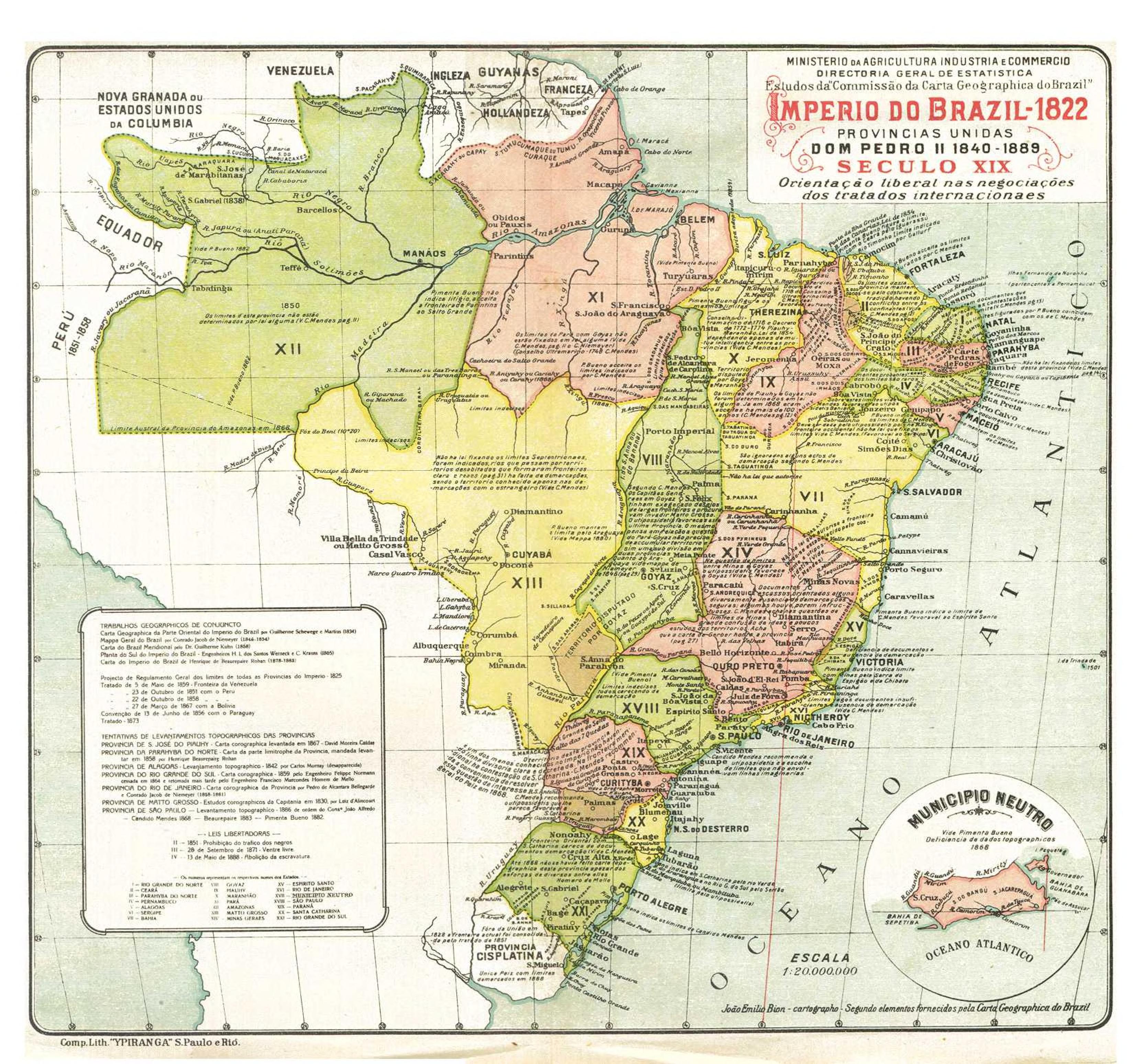
Brazilian Empire Map
Hi, could you please change your maps of the brazilian empire in the santa catarina region? They are inacurate, the area was disputed with argentina and largely depopulated but had brazilian de facto control. Since it was de jure awarded to brazil later it would be better if the maps represented it as a brazilian territory. Also the São Paulo province frontier it's wrong.
These maps represent the frontiers of Santa Catarina province and São Paulo province at the time (in 1853 the Parana province was split from São Paulo, but it's frontiers were the same).
http://objdigital.bn.br/objdigital2/acervo_digital/div_cartografia/cart171159/cart171159.jpg, http://objdigital.bn.br/objdigital2/acervo_digital/div_cartografia/cart163355/cart163355.jpg, https://upload.wikimedia.org/wikipedia/commons/0/08/Imperio_do_Brazil_1822.jpg e https://acaosp.files.wordpress.com/2015/08/centro-sul.jpg?w=284&h=403. — Preceding unsigned comment added by Renato Rocha (talk • contribs) 03:59, 21 November 2017 (UTC)
![]() Not done
Not done
Russian empire map
Good day! You forgot about Western Armenia [7] zone on this [8] map. Please, add this information
![[8]](https://en.m.wikipedia.org/wiki/Russian_Empire#/media/File%3ARussian_Empire_(orthographic_projection).svg)
If you want read smith: [9], [10], [11], and [12]
![[10]](https://en.m.wikipedia.org/wiki/File:Western_Armenia_Russian_occupation_1916.jpg)
Thanks ~~ NikolayMoscow (talk) 18:41, 20 January 2018 (UTC)
- Thank you very much!!!!! I've seen your map (version 21.02.2018)!
But, I have an addition. Lake Sevan is uncluded in Russian sphere of influence. See [13] and [14]. But in your version, this lake doesn't included. If you add this territory, it will be more correctly.
--NikolayMoscow (talk) 10:21, 8 March 2018 (UTC)
![]() Done
Done
![[14]](https://ru.wikipedia.org/wiki/%D0%A4%D0%B0%D0%B9%D0%BB:Western_Armenia_September_1917.png)
Mapas de Colombia
Hola Shadowfox, gracias por su trabajo.
Quería preguntarle si tiene los mapas de Colombia de 1928 y 1942 con municipios en formato .shp para usar en GIS. Saludos
Muribec123 (talk) 16:49, 1 February 2018 (UTC) MUC
![]() Answered
Answered
.svg&action=edit&redlink=1)
|
|
File:Gran Colombia (1826).svg has been listed at Commons:Deletion requests so that the community can discuss whether it should be kept or not. We would appreciate it if you could go to voice your opinion about this at its entry.
If you created this file, please note that the fact that it has been proposed for deletion does not necessarily mean that we do not value your kind contribution. It simply means that one person believes that there is some specific problem with it, such as a copyright issue. Please see Commons:But it's my own work! for a guide on how to address these issues. |
.svg)
Túrelio (talk) 21:16, 25 February 2018 (UTC)
.svg)
.svg&action=edit&redlink=1)
|
|
File:Gran Colombia (1824).svg has been listed at Commons:Deletion requests so that the community can discuss whether it should be kept or not. We would appreciate it if you could go to voice your opinion about this at its entry.
If you created this file, please note that the fact that it has been proposed for deletion does not necessarily mean that we do not value your kind contribution. It simply means that one person believes that there is some specific problem with it, such as a copyright issue. Please see Commons:But it's my own work! for a guide on how to address these issues. |
.svg)
Túrelio (talk) 21:18, 25 February 2018 (UTC)
.svg)
A barnstar for you!

|
The Brilliant Idea Barnstar |
| Thank you for your map ([15]) NikolayMoscow (talk) 10:41, 8 March 2018 (UTC) |
![[15]](https://commons.wikimedia.org/wiki/File:Russian_Empire_(orthographic_projection).svg?uselang=ru)
|
|
File:Flag of Necoclí.svg has been listed at Commons:Deletion requests so that the community can discuss whether it should be kept or not. We would appreciate it if you could go to voice your opinion about this at its entry.
If you created this file, please note that the fact that it has been proposed for deletion does not necessarily mean that we do not value your kind contribution. It simply means that one person believes that there is some specific problem with it, such as a copyright issue. Please see Commons:But it's my own work! for a guide on how to address these issues. |
·×ald·es 04:52, 27 March 2018 (UTC)
Upload request|Administrative location map of province of Nepal
Hi Shadow, I finally found you who is actively involved in creating adm location map. I would like to request you to make following adm location map of Provinces of Nepal. I know it is lots of stuff to do. Take your time.
Thanks in advance--Biplab Anand (Talk) 04:51, 18 May 2018 (UTC)
![]() Not done
Not done
.svg)
Buenas tardes Shadowxfox.
Estoy usando el mapa creado por usted para realizar un mapa de los resultados de la primera vuelta electoral por municipios; sin embargo noto con extrañeza un error en dicho mapa en el cual no aparece el municipio de Cuítiva y su territorio aparece fusionado con Aquitania, probablemente se confundió el limite entre los municipios con la letra a final de Boyacá. Agradezco si puedes corregir este pequeño error lo antes posible. --CarlosArturoAcosta (talk) 19:16, 28 May 2018 (UTC)
![]() Done
Done
.svg)
Job to do
Hi,
- The map of es:Distrito de Donoso has to be updated, as the es:Distrito Especial Omar Torrijos Herrera has to be uncolored (west side of Rio Coclé del Nte).
- A map for es:Distrito Especial Omar Torrijos Herrera has to be created.
- Other files in Category:Maps of districts of Colon Province have to be updated with the new district border
Regards,
OldBee (talk) 21:51, 9 June 2018 (UTC)
![]() Not done
Not done
Fuente Mapa Vial Colombia
Cordial saludo.
Escribo con el propósito de conocer como debo citar el Mapa Vial de Colombia (2014) que aparece bajo tu elaboración. Te pregunto, tienes uno similar más actualizado? y por otro lado? tienes uno disponible con los nombres de los departamentos?
Agradezco mucho tu contribución.
Cordialmente, Maira Torres
INVEMAR. — Preceding unsigned comment was added by 190.131.210.192 (talk) 18:18, 6 July 2018 (UTC)
![]() Not done
Not done
|
|
File:Bandera de la Provincia de Los Santos.svg has been listed at Commons:Deletion requests so that the community can discuss whether it should be kept or not. We would appreciate it if you could go to voice your opinion about this at its entry.
If you created this file, please note that the fact that it has been proposed for deletion does not necessarily mean that we do not value your kind contribution. It simply means that one person believes that there is some specific problem with it, such as a copyright issue. Please see Commons:But it's my own work! for a guide on how to address these issues. |
Ganímedes (talk) 14:19, 22 July 2018 (UTC)
Actualizar mapa de tipo de municipios
Hola! Podrías actualizar el mapa File:Mapa de Colombia (tipos de municipios).svg?. Cali ahora es un distrito. Sahaquiel - Hast du eine Frage? ![]() 00:46, 3 August 2018 (UTC)
00:46, 3 August 2018 (UTC)
![]() Done
Done
.svg)
Historical locator maps
Somaliland
Regarding your historic locator maps (which a really appreciate), you made a typical mistakes reagarding the borders of naiighboring countries that can be found on so many maps. For the pre-1993 Ethiopia map, you show the post-2000 boundaries of Yemen, as well as for the Somaliland maps, for which the then undefined bordes of South Arabia need further adaption. There is de:Benutzer:Antemister/Weltkarten, a hopefully complete chronicle of border changes as far back as about 1950. Should you want to correct the maps (what I hope, of course), I can provide you material. And in case you draw similar maps in the future, it might be better you ask me first, although I am not sure if I know any detail by heart.--Antemister (talk) 08:59, 19 September 2018 (UTC)
- Hello @Antemister:
- I appreciate your help and your indications, but ¿could you tell me exactly which maps? I have uploaded many (really MANY) historical locator maps of different countries and subdivisions, and I do not know exactly who you are referring to. For Ethiopia, for example, I uploaded locators of the country and the historical provinces.
- --Shadowxfox (talk) 20:48, 19 September 2018 (UTC)
- I know how many maps you uploaded (I monitor that for years), but up to now I did not find any mistakes that stick out (maybe because I did not that much research reagrding latin america yet). At first, only the pre-2000 borders of Yemen for the Ethiopa maps (easy to research, for example [16]. For the Somaliland map, the undefined borders in South Arabia are a special issue - will provide you with an old british military map which I do not have here next weekend.--Antemister (talk) 21:58, 19 September 2018 (UTC)
![[16]](https://3.bp.blogspot.com/-uPS6yX0UAVw/WPHm6cAdLFI/AAAAAAAAFM8/qJWbpq90GYAyJ6cvkr4omkcJv5O-1_14wCLcB/s1600/Yemenmap19702.png)
@Antemister: Thanks, but, ¿are you referring to the borders of these maps?
- File:Ethiopia in its region (before 1993).svg
- File:Italian Somaliland in its region.svg
- File:British Somaliland in its region.svg
.svg)
With respect to Latin America, the majority of borders were disputed, since these were not defined until the early 20th century, as you can see in these maps:
- File:Latin America Major International Boundary Disputes.jpg
- File:South America 1879.png
- File:Territorial disputes in the Platine region in 1864-es.svg
- Yes, these are the maps I means. The first one, Ethiopia in its region (before 1993).svg, you can correct easily with the map I linked. For the two other maps, it wourld be necessary to define a specific year. The preliminary borders of Yemen exist from 1955 on, so its simple if you define those two maps as relating to year after 1955. If not, than you could use the boundaries on that british military map I mentioned. At them moment I am also checking the Pre-WWII-Soviet Union maps.--Antemister (talk) 09:48, 20 September 2018 (UTC)
![]() Done
Done
Mali & Vietnam
- The map of the Mali Federation must to take into acconu the treaty of Kayes (1963),[17]
- The maps of divided Vietnam must include Sikkim
- The Somaliland maps must have a state boundary between AEF and AOF, and also the borders in British East Africa should be normal state boundary. Dashed lines imply disputed boundaries.
![[17]](http://fall.fsulawrc.com/collection/LimitsinSeas/maps/BS23a.jpg)
--Antemister (talk) 22:32, 28 October 2018 (UTC)
@Antemister: ok, but before continuing with this with each map that I draw, ¿can you look at ALL the maps in this category and tell me what needs to be improved in them? make me a list right here in my discussion and I will make SVG maps with these modifications. --Shadowxfox (talk) 01:13, 29 October 2018 (UTC)
- OK; can/will do that. Of course it is, at least at the moment not reasonably possible for pre-1945 times ore even pre-modern states (for which the maps often show modern boudaries). Maps I do not mentions here are those I do not have sufficient information at the moment.
Asia:
- File:LocationUnitedArabKingdom.png, File:LocationFederationofArabEmirates.png, File:LocationKuwaitSaudiNZ.png, File:LocationUnitedArabRepublic.png, File:LocationUnitedArabRepublic2.png, will send you a map with the evolution of the arabian boundaries. guess that it will be sufficient, please send me an email.
- File:North Yemen in its region.svg, File:North and South Yemen in their region.svg, File:South Yemen in its region.svg, File:Federation of South Arabia in its region.svg. The mentioned Yemen issue [18], [19] is more detailed for the Aden-North Yemen boundary, be aware the the todays provincial division of Yemen does not exactly follow the pre-1990 boundary between the divided nation [20]
- The USSR is at the moment a bigger problem, I asked the german graphist who origianally created the white-red locator maps for a better map of the USSR.
![[19]](https://commons.wikimedia.org/wiki/File:FederationOfSouthArabiaMap.jpg)
![[20]](https://commons.wikimedia.org/wiki/File:Divided_Yemen.svg)
Africa:
- File:LocationBiafra.PNG, File:LocationCentralAfricanEmpire.png, File:LocationRepofBenin.PNG nothing else than the Sudan-South Sudan and Ethiopia-Eritrea boundary if visible
- File:LocationSouthAfrica-1990.png only Walvis Bay;-)
- --Antemister (talk) 10:30, 30 October 2018 (UTC)
@Antemister: Done all the countries of Africa mentioned. Respect to Yemen, should be included the neutral zones and the Israeli occupation of the Sinai Peninsula (1967-1982)? if you can, send me that email with the borders of Saudi Arabia. --Shadowxfox (talk) 12:47, 31 October 2018 (UTC)
- Actually you have to sent me an eMail first, the Wikimail function does not allow attachments. The neutral Zones need to be included, but not the Israeli occupation of the Sinai Peninsula, because it there was never a formal annexation or civil administration (that leads to another question, how to deal correctly with the west Bank before 1988 (the year Jordan gave up its claims)?)--Antemister (talk) 18:02, 31 October 2018 (UTC)
- PS: Do you have a subscription for Geacron and/or the Hisatlas?--Antemister (talk) 18:11, 31 October 2018 (UTC)
@Antemister: I know those sites, I'm not subscribed but if I have them in my favorites for a long time. Concerning the West Bank dispute, it can be scratched as in these maps File:India in its region (disputed hatched).svg, File:India in its region (claimed hatched).svg. I will send you an email these next days to receive the mentioned map. --Shadowxfox (talk) 09:41, 1 November 2018 (UTC)
![]() Done
Done
.svg)
.svg)
Hola ShadowxFox, en primer lugar quería agradecerte por la creación de este mapa de Colombia, en serio que hacía mucha falta un material de calidad donde se graficaran los municipios del país en su totalidad.
Sin embargo quisiera hacerte una sugerencia a modo de cuestión, y tomando en cuenta que Bogotá es la única región a la que no se le muestra en el mapa su división administrativa, lo cual hace ver esa parte del mapa algo extraño y raya un poco con el resto (lo cual es natural pues es la situación real del régimen administrativo de Bogotá); así que mi pregunta es: ¿No quedaría mejor graficar también las "localidades" de Bogotá y aclarar su caso particular? Considero que con una aclaración en la leyenda o poniéndole otro color a sus divisiones quedaría suficientemente claro y el mapa quedaría "completo" con una gran calidad informativa.
Espero tomes en cuenta mi sugerencia y muchas gracias por todos estos aportes al conocimiento enciclopédico de Colombia, sé bien cuanto trabajo hay detrás.
--LeinadCQ (talk) 07:34, 10 November 2018 (UTC)
.svg)
- Por cierto que en Cundinamarca los municipios de Cabrera y San Bernardo aparecen unidos. --LeinadCQ (talk) 01:07, 15 November 2018 (UTC)
@LeinadCQ: Gracias, pero para eso ya está File:Mapa de Colombia (subdivisiones).svg, que tiene mucho mayor detalle e incluye todas las localidades de Bogotá. --Shadowxfox (talk) 01:48, 2 December 2018 (UTC)
.svg)
.svg)
- Bueno ShadowxFox aunque me parece un mejor formato el del mapa que te comento. Y revisándolo mejor también noté que Íquira y Teruel en el Huila están superpuestos, que tengas buen día. --LeinadCQ (talk) 05:48, 2 December 2018 (UTC)
![]() Done
Done
Errata
hola: te paso un fallo que he encontrado en el mapa: ![]() , faltan los Presidios de Toscana parte del Reino de Nápoles.
Un saludo. --Parair (talk) 14:07, 20 November 2018 (UTC)
, faltan los Presidios de Toscana parte del Reino de Nápoles.
Un saludo. --Parair (talk) 14:07, 20 November 2018 (UTC)
- A parte de que la nomemclatura sería Reino de Nápoles y de Sicilia porque era una unión personal bajo un Infante de España. Aunque sí, el reino de Nápoles es también Sicilia, Regnum Siciliæ citra Pharum, de Aquende o Penínsular. --Parair (talk) 14:10, 20 November 2018 (UTC)
![]() Not done
Not done
Locator maps category
Hola Shadowxfox- After seeing the template at Category:Location_maps_of_Massachusetts, I wonder if we have a definition somewhere for "locator map". I think that would be a good addition to the top of Category:Locator_maps_of_Massachusetts and the other locator map cat pages. Thanks in advance for any tips. Eric talk 19:56, 2 December 2018 (UTC)
An error on your Russian expansion map
Hello,
On this map of yours ( https://commons.wikimedia.org/wiki/File:Expansi%C3%B3n_territorial_de_Rusia.svg ), you incorrectly portrayed Kiev as falling under Russian rule in 1772. However, the Wikipedia article for Kiev says that it fell under Russian rule in 1667. In fact, some of the maps that you used as sources for your own map likewise show Kiev as falling under Russian rule in the late 1600s. Thus, I was wondering if you would be willing to fix this error on your map.
Have a good day and best regards,
Futurist110 (talk) 04:46, 2 January 2019 (UTC)
![]() Not done
Not done