User talk:Clyde H. Mapping
|
Our first steps tour and our frequently asked questions will help you a lot after registration. They explain how to customize the interface (for example the language), how to upload files and our basic licensing policy (Wikimedia Commons only accepts free content). You don't need technical skills in order to contribute here. Be bold when contributing and assume good faith when interacting with others. This is a wiki. More information is available at the community portal. You may ask questions at the help desk, village pump or on IRC channel #wikimedia-commons (webchat). You can also contact an administrator on their talk page. If you have a specific copyright question, ask at the copyright village pump. |
|
-- Wikimedia Commons Welcome (talk) 21:16, 31 January 2020 (UTC)
- Bonjour, vous souhaiteriez que je fasse des cartes à l'aide de quel logiciel ? Gogotus (talk) 14:58, 10 December 2022 (UTC)
.svg)
Map of political regimes[edit]
Hello, what software would you like me to use to make maps? Gogotus (talk) 17:35, 10 December 2022 (UTC)
- Updates at Forms of government 2021.svg are best suited to plain text editors. As stated by Template:NoInkscape on the page's summary, in order to keep the map in text-editable form, vector editors should not be used. Clyde H. Mapping (talk) 01:16, 11 December 2022 (UTC)
Mali War map[edit]
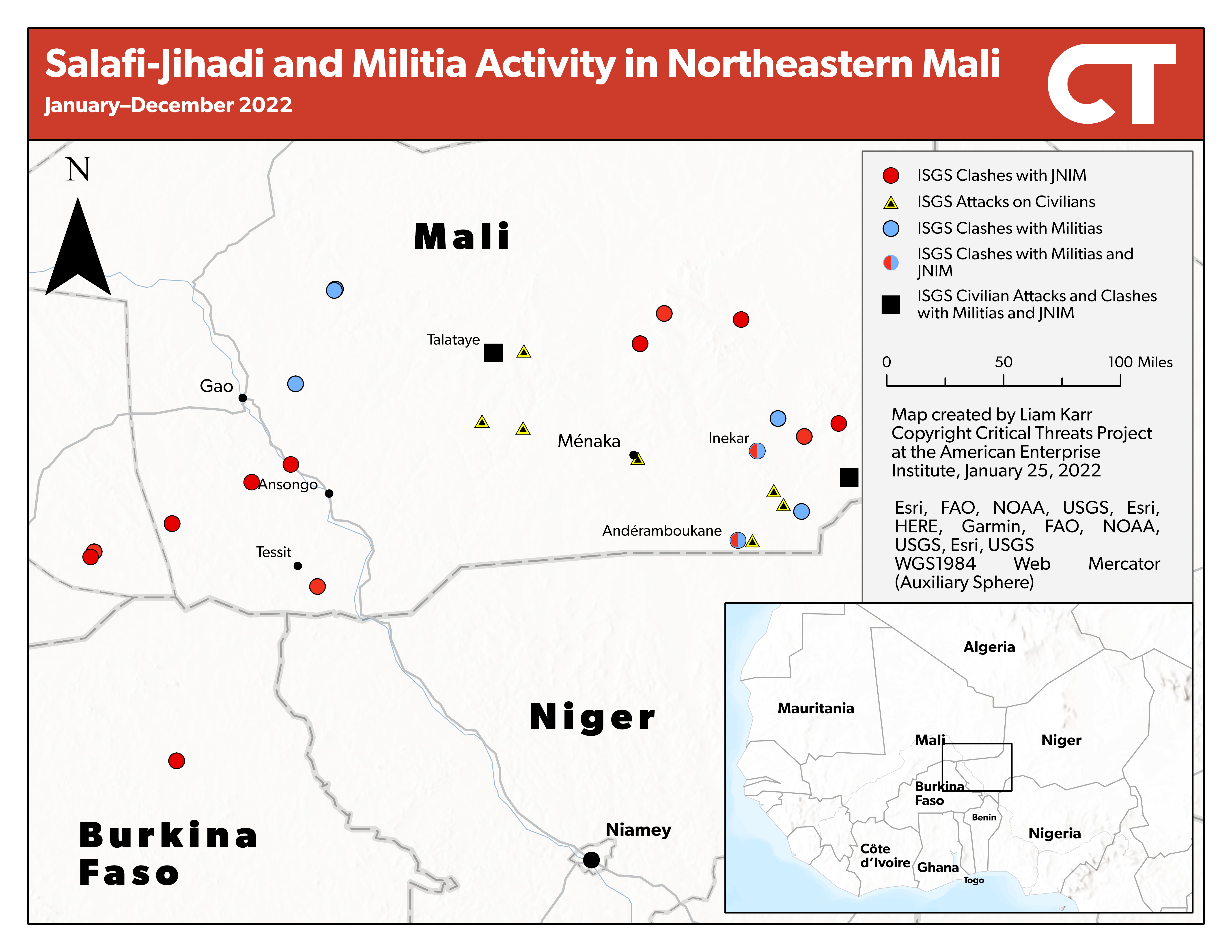
Thanks for updating the map, If you want to update it better here is a map of clashes between ISGS and different groups, it's a few months out of date though. https://www.criticalthreats.org/wp-content/uploads/20230125-Sahel-Weekly-SJ-1.png Garmin21 (talk) 13:15, 12 April 2023 (UTC)

|
File:Wagner Revolt map.svg has been listed at Commons:Deletion requests so that the community can discuss whether it should be kept or not. We would appreciate it if you could go to voice your opinion about this at its entry.
If you created this file, please note that the fact that it has been proposed for deletion does not necessarily mean that we do not value your kind contribution. It simply means that one person believes that there is some specific problem with it, such as a copyright issue. Please see Commons:But it's my own work! for a guide on how to address these issues. |
Request[edit]
Can you please create a Myanmar Civil war(2021-present) full map? i see you created one for Operation 1027, a full one would be helpful, Thanks! Lucasoliveira653 (talk) 16:27, 10 November 2023 (UTC)
- I have made one, File:Internal conflict in Myanmar.svg, though it is outdated and no longer properly sourced. I may update it if I can find enough new sources to do a rework, though the lack of reporting makes doing so considerably more difficult compared to other ongoing conflicts (probably why no one else has tried so far). Clyde H. Mapping (talk) 18:46, 10 November 2023 (UTC)
- @Clyde H. Mapping: Hey, for what it's worth: I just found a map of the current situation (as of 1 December), made by Dutch conflict journalist Thomas van Linge, based on open source intelligence.[1][2] --Grnrchst (talk) 12:38, 2 December 2023 (UTC)
- While it is more detailed than the past one, 25stargeneral correctly pointed out that using a third-party map might violate English Wikipedia's policy against original research. Clyde H. Mapping (talk) 03:49, 3 December 2023 (UTC)
- I think we can still use the map, the question is, should we add it as a new file or we make a SVG map of it? Lucasoliveira653 (talk) 19:48, 6 December 2023 (UTC)
- Maps are best suited to SVG. Clyde H. Mapping (talk) 06:15, 7 December 2023 (UTC)
- I think we can still use the map, the question is, should we add it as a new file or we make a SVG map of it? Lucasoliveira653 (talk) 19:48, 6 December 2023 (UTC)
- While it is more detailed than the past one, 25stargeneral correctly pointed out that using a third-party map might violate English Wikipedia's policy against original research. Clyde H. Mapping (talk) 03:49, 3 December 2023 (UTC)
- @Clyde H. Mapping: Hey, for what it's worth: I just found a map of the current situation (as of 1 December), made by Dutch conflict journalist Thomas van Linge, based on open source intelligence.[1][2] --Grnrchst (talk) 12:38, 2 December 2023 (UTC)
![[2]](https://www.mediafire.com/file/uarsqrwkg36ry5l/2000px-Myanmar.png/file)
Hello Clyde,
There is currently a request on the English Wikipedia concerning the statistics of Russia in File:Ongoing conflicts around the world.svg. Since you've been active updating the map, I'd imagine your comments would be appreciated. Have a happy New Year, NotAGenious (talk) 15:07, 31 December 2023 (UTC)
Sorry, can You fix the color of the Crimean peninsula (follow the UN-confirmed state borders) and re-upload this map with correctly colored area? Thanks. Nahabino (talk) 16:56, 4 January 2024 (UTC)
 Done Clyde H. Mapping (talk) 17:25, 4 January 2024 (UTC)
- Thanks! Nahabino (talk) 20:08, 23 January 2024 (UTC)
Sourcing for c:File:Iraqi Civil War map (2014–present).svg[edit]
.svg)
Can you tell me what source you've used for the Turkish occupation of Northern Iraq? I have also seen some maps depicting this in the past but nothing on reliable sources. Ecrusized (talk) 15:12, 21 January 2024 (UTC)
.svg)
- en:Module:Iraqi insurgency detailed map; in general a Turkish presence is well-supported ([3], [4], [5], [6]) though if the specific bases aren't then feel free to submit a verified update to the module and I'll revise accordingly. Clyde H. Mapping (talk) 21:13, 21 January 2024 (UTC)
- It's all a bit muddy when it comes down to the Turkish presence in Iraq. As far as I know, it's quite different than their occupation of Syria. As they don't control settlements there, but they have dozens of military bases in covert collaboration with the KDP. As far as showing where they are present goes, I think most mappers color the areas where they have bases in general. This Twitter account called @ConflictTR has an interactive map. Might be best to adjust it according to this and give them the proper attribution for it. Ecrusized (talk) 11:00, 23 January 2024 (UTC)
- Also, I have to ask what you've cited for Iraqi Kurdistan borders. They are quite weird, specifically around Kirkuk compared to what I've seen on liveuamap. Ecrusized (talk) Ecrusized (talk) 11:20, 23 January 2024 (UTC)
- I drew the borders by hand roughly based on the settlements in the module, but tracing in the one used by the original map is really no problem. As for the Turkish presence, this map appears credible from what I know about the region, though I can't find any sources tied to it and there are some apparent problems (e.g. SDF territory conflated as PKK territory is debatably less than neutral). I have seen other maps displaying bases such as one by Suriyak which also separates the Kurdish factions, so there's plenty to work with. Clyde H. Mapping (talk) 14:36, 23 January 2024 (UTC)
- Module maps are usually made up non-sense. I would never cite them. Also, Wikipedia is not a source. Ecrusized (talk) 15:03, 23 January 2024 (UTC)
- I've uploaded a version with tweaked borders. Since it appears that a good amount of Turkish outposts are outside of the Claw-Lock area I won't be coloring the surrounding territory since the maps don't treat them as occupations. Clyde H. Mapping (talk) 15:40, 23 January 2024 (UTC)
- Very well. You should probably give Suriyak some attribution in the file description too. Ecrusized (talk) 16:05, 23 January 2024 (UTC)
- I've uploaded a version with tweaked borders. Since it appears that a good amount of Turkish outposts are outside of the Claw-Lock area I won't be coloring the surrounding territory since the maps don't treat them as occupations. Clyde H. Mapping (talk) 15:40, 23 January 2024 (UTC)
- Module maps are usually made up non-sense. I would never cite them. Also, Wikipedia is not a source. Ecrusized (talk) 15:03, 23 January 2024 (UTC)
- I drew the borders by hand roughly based on the settlements in the module, but tracing in the one used by the original map is really no problem. As for the Turkish presence, this map appears credible from what I know about the region, though I can't find any sources tied to it and there are some apparent problems (e.g. SDF territory conflated as PKK territory is debatably less than neutral). I have seen other maps displaying bases such as one by Suriyak which also separates the Kurdish factions, so there's plenty to work with. Clyde H. Mapping (talk) 14:36, 23 January 2024 (UTC)
Erbil in map[edit]
Hello! I'm just wondering why Erbil is on the US military base attacks? That was an Iranian attack against a supposed Mossad base, I dont think it counts Personisinsterest (talk) 03:40, 3 February 2024 (UTC)
- Corrected. Clyde H. Mapping (talk) 04:02, 3 February 2024 (UTC)
- Thank you! Personisinsterest (talk) 12:08, 3 February 2024 (UTC)