User:Sting/Gallery: Regional maps
| My images galleries |
|---|
| Maps: Maps of the world, of seas and about history - Regional maps - Location and locator maps -- go back to my main user page -- |
Welcome in my gallery of regional maps. All maps here were created by myself (Eric Gaba, as username Sting).

I authorize anybody to use my photographs, maps or schemes outside the Wikimedia projects (Wikipedia in different languages, Commons, Wikibooks, Wikisource, etc.), on an other Web site or in publications, for commercial or non-commercial use. No written authorization is necessary, as long as you respect the terms of the license under which the image is publicized (especially that I am credited as author, when required), but a message from you on my discussion page with a reply address would be greatly appreciated.
![]() This user is a Wikigraphist from the Atelier graphique to whom you can propose images or maps to improve.
This user is a Wikigraphist from the Atelier graphique to whom you can propose images or maps to improve.
Note: Maps are organized by geographic areas and themes first rather than by country.
Maps of Africa[edit]
-
-
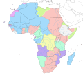
 Political map of Africa (slight differences with African_continent-fr.svg)
Also : blank version -
 Geographical distribution map of the lion
 -
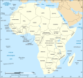
 Colonial Africa in 1913


Mauritius[edit]
-

-
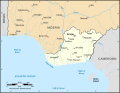
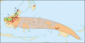
 Bathymetric environment of Rodrigues Island
 -
-

-
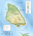
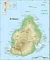 Topographic map of Mauritius Island
Also : SVG version


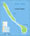
French Scattered islands in the Indian Ocean[edit]


Tunisia[edit]


Miscellaneous maps of Africa[edit]
-
-
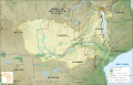 Zambezi river hydrographic basin
 -
 Animated map of the recent eruptions of the Piton de la Fournaise shield volcano
Also : Steady map ;
Topographic map -


Maps of North America[edit]
-
 Map of Alaska's area compared to the 48 conterminous United States
 -
-

-

-

-
-
 Map of Saint-Pierre and Miquelon's EEZ
 -

-


Maps of Central America and Caribbean[edit]
-

-
 Topographic map of the Caribbean island of Saint Martin
Also : in English -
 Numbered map of the Quartiers and parishes of Saint-Barthélemy
 -
 Topographic map of the Caribbean archipelago of Saint-Barthélemy
 -


Maps of South America[edit]
-
 Topographic map of the Falkland Islands
 (on Commons and WP-en)
Also : in French
simpler version in English
simpler version in French -
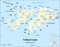 Map of the Falkland Islands, with shaded relief
Also : in French -
 Topographic map of Easter Island
 -
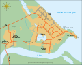 City map of Kourou, French Guyana
 -


Maps of Asia[edit]
-

-
 Location map of Petra, Jordan
 -


Maps of Europe[edit]

France[edit]
-
 Blank map of metropolitan France (Lambert-93 projection)
Also : completely blank
with regions
with regions and departments
with regions and departments as independent polygons
with regions and rivers -
 Blank topographic map of metropolitan France (Lambert-93 projection)
Also : with regions -
 Blank map of metropolitan France (Mercator projection)
 -
 Labour protests against the CPE in France the 23rd of March 2006
 -
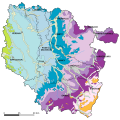 Geologic map of Lorraine
 -
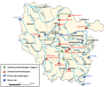 Hydrologic map Lorraine
 -
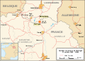 Map for the Zoufftgen train crash
 -
 Blank map of the département of the Gironde
 -
 Map of the nuclear power plants in France
 -
 Forests of the département of the Yvelines (France)
 -
 Noise area around the Marseille-Provence airport
Also : Lden level 55 map
Lden level 65 map
Lden level 70 map -

-
 Map of the Pyrenees, with shaded relief
 -

-
 Map of Crau's biome area
 -
 NATO air bases in France until 1966
Also : in English


Greece[edit]
-
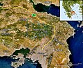 Map of Mount Parnitha's region
Also : blank version -

-
 Map of the Saronic Gulf, Greece
 -

-
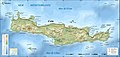
 Relief map of Crete, Greece
 -
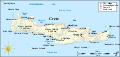
 Topographic map of Crete
Also : SVG version -
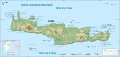
 Integrated map of Crete
 -
 Blank relief map of Peloponnese, Greece
 -
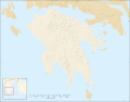 Blank map of Peloponnese, with shaded relief
 -

-
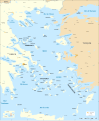 Full SVG map of the Aegean Sea
 -
 Topographic map of Chios and Psara islands, Greece


United Kingdom[edit]
-

-
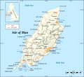 Map of the Isle of Man
Also : in French -
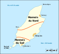 Map of the Manx dialects
 -

-
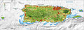
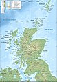 Topographic map of Scotland
Also : in English
SVG version in French
SVG version in English
Simplified version -
-
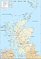
 Land cover of Scotland
Also : in English -
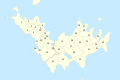
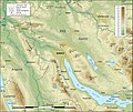
 Topographic map of the archipelago of St Kilda


Miscellaneous maps of Europe[edit]
-
 Map of the radiation hotspots in 1996 resulting from the Chernobyl nuclear accident
 -
 Topographic map of Andorra
 -
-
 Transportation map of the area of Zürich
 -
 Blank topographic map of Italy
 -
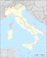 Blank administrative map of Italy
 -
 Map of Svalbard archipelago


Maps of Oceania[edit]
-
 Distribution of the Regiae, a group of the Nepenthes carnivorous pitcher plants
 -

-
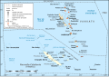 Administrative and simplified version of the former
 -


