User:Dbenbenn/maps
Jump to navigation
Jump to search

Lately I've been making maps with data from nationalatlas.gov. Here's a representative list.
-
 I uploaded a county locator map for every county in the US
 -
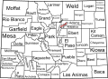 A map showing the counties in Colorado
 -
 This and other historical maps of Colorado
 -
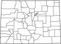
 This and other Colorado county maps
 -
 This and other Colorado national forest maps
 -
 This and other Colorado wilderness area maps
 -
 Interstate Highways in the contiguous United States
 -

-
 The Unorganized Borough in Alaska


I'd like to make locator maps for national forests, national parks, interstate highways, rivers, etc. There's a lot to do!