Gullfoss
Pronunciation of the name of Gullfoss[edit]
Location of Gullfoss[edit]
The waterfall is situated at the southern end of Kjölur highland road, and not far from one of the biggest ice caps of Iceland, Langjökull.
-
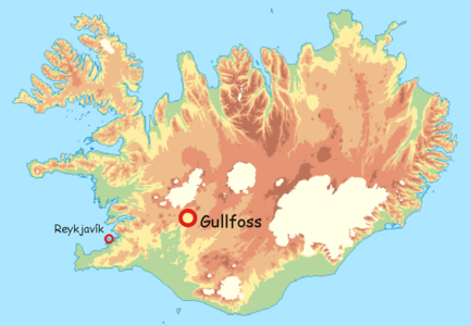 Localisation of Gullfoss
 -
 Kjölur highland road


Panoramics of Gullfoss[edit]
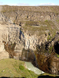
The waterfall has two steps, about 10 m and about 20m high each, over which the waters tumble down into the over 70 m deep canyon of Hvítárgljúfur.
-
 The waterfall seen from the view point next to the coffeeshop
 -
 The walls of the canyon consist mainly of lava.


Upstream impressions of the river Hvítá[edit]
-
 Rapids in the river Hvítá upstream of the waterfall
 -

-

-

-


The upper part of Gullfoss[edit]
An erosional step of 11 m.


.JPG)


Impressions of both parts of the waterfall[edit]
The two steps form an angle of about 90°. Faults and contrasting lithologies determine the form of the falls. There is a sequence of two different lava formations alternating with sediments around and under Gullfoss and Hvítárgljúfur.
.jpg)

The lower part of Gullfoss[edit]
A 21 m step.
-

-

-
 This could be a small jökulhlaup: Compare the volume of water and the water colours, they show an increase in sediment load.
 -

-

-

-


.jpg)
.jpg)


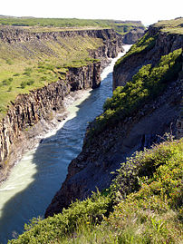
Hvítárgljúfur, the canyon[edit]
It has a length of 2,5 km and a depth of about 70 m. At the same time, the canyon is in line with a tectonic fault beneath the valley.
-
 Seen from direction of Brattahlíd
 -

-
 Many different lava flows built the walls of this canyon.
 -
-

-

-
 The walls of Hvítárgljúfur


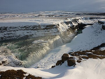
Gullfoss in the winter time[edit]
-

-
-
 Hvítárgljúfur in the winter time
 -

-

.JPG)
.JPG)


Highland of Iceland, seen from Gullfoss[edit]
Most part of the waters of Hvítá is glacial meltwater from Langjökull and Hofsjökull. The highland and the glaciers can be seen from the waterfall.
-
 Gullfoss in April, in Iceland still winter time; view of the waterfall and the highland in direction of the mountain Bláfell and the mountain range of Kerlingarfjöll and Hofsjökull
 -
 The same view in July
 -
 The mountain Bláfell, former home of a troll
 -
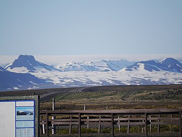 Zoomed view of ice cap w:Langjökull and its volcanic mountains from the parking lot in front of Gullfoss coffeshop


.jpg)
