File:U.S. states by 2009 MUTCD adoption.svg
Jump to navigation
Jump to search

Size of this PNG preview of this SVG file: 800 × 495 pixels. Other resolutions: 320 × 198 pixels | 640 × 396 pixels | 1,024 × 633 pixels | 1,280 × 791 pixels | 2,560 × 1,583 pixels | 959 × 593 pixels.
Original file (SVG file, nominally 959 × 593 pixels, file size: 74 KB)
Captions
Captions
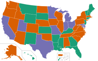
map of U.S. states and territories color-coded by adoption of the 2009 edition of the Manual on Uniform Traffic Control Devices
Summary[edit]
| Description |
English: A map of U.S. states and territories color-coded by adoption of the 2009 edition of the Manual on Uniform Traffic Control Devices. Color-coding is based on this color scheme.
Legend: Adopted the 2009 MUTCD
Adopted the 2009 MUTCD along with a state supplement
Adopted a state MUTCD in conformance with the 2009 MUTCD |
| Date | |
| Source |
Own work based on:
|
| Author | Minh Nguyen |
| Other versions |
This file was derived from: Blank USA, w territories.svg |
![[1]](https://mutcd.fhwa.dot.gov/resources/images/states/statesmutcdmap.gif)
Licensing[edit]
I, the copyright holder of this work, hereby publish it under the following license:
| This file is made available under the Creative Commons CC0 1.0 Universal Public Domain Dedication. | |
| The person who associated a work with this deed has dedicated the work to the public domain by waiving all of their rights to the work worldwide under copyright law, including all related and neighboring rights, to the extent allowed by law. You can copy, modify, distribute and perform the work, even for commercial purposes, all without asking permission.
|
File history
Click on a date/time to view the file as it appeared at that time.
| Date/Time | Thumbnail | Dimensions | User | Comment | |
|---|---|---|---|---|---|
| current | 02:48, 12 January 2021 | | 959 × 593 (74 KB) | Mxn (talk | contribs) | Uploaded own work with UploadWizard |
You cannot overwrite this file.
File usage on Commons
The following 5 pages use this file:
File usage on other wikis
The following other wikis use this file:
- Usage on de.wikipedia.org
- Usage on en.wikipedia.org
- Usage on es.wikipedia.org
- Usage on www.wikidata.org