File:Topographische kaart der residentie Pekalongan.tif
Jump to navigation
Jump to search

Size of this JPG preview of this TIF file: 738 × 599 pixels. Other resolutions: 296 × 240 pixels | 591 × 480 pixels | 946 × 768 pixels | 1,261 × 1,024 pixels | 2,522 × 2,048 pixels | 8,906 × 7,232 pixels.
Original file (8,906 × 7,232 pixels, file size: 184.29 MB, MIME type: image/tiff)
Captions
Captions
Add a one-line explanation of what this file represents
Summary[edit]
| Description |
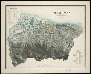
English: Title: Topographische kaart der residentie Pekalongan Subtitle: opgenomen ingevolge gouvernements besluit d.d. 27 mei 1863 No. 19 Statement of responsibility: overgebragt en geteekend doo G.F.M. Bajetto. Author/creator: Bajetto, G.F.M. Shelfmark: KK 115-01-04/05 Note: Gegevens verzameld over de periode/Data collected over the period: 1870. Language: Dutch Country: Netherlands Published/created: 's Gravenhage : 's Gravenhage : Topographische inrichting, [1870] Persistent URL: http://hdl.handle.net/1887.1/item:1995707 Extent: Digital image |
| Date | |
| Source | http://hdl.handle.net/1887.1/item:1995707 |
| Author | Bajetto, G.F.M. |
Licensing[edit]
This file is licensed under the Creative Commons Attribution 4.0 International license.
- You are free:
- to share – to copy, distribute and transmit the work
- to remix – to adapt the work
- Under the following conditions:
- attribution – You must give appropriate credit, provide a link to the license, and indicate if changes were made. You may do so in any reasonable manner, but not in any way that suggests the licensor endorses you or your use.
File history
Click on a date/time to view the file as it appeared at that time.
| Date/Time | Thumbnail | Dimensions | User | Comment | |
|---|---|---|---|---|---|
| current | 04:09, 29 August 2021 |  | 8,906 × 7,232 (184.29 MB) | Nanterjen (talk | contribs) | Uploaded a work by Bajetto, G.F.M. from http://hdl.handle.net/1887.1/item:1995707 with UploadWizard |
You cannot overwrite this file.
File usage on Commons
There are no pages that use this file.