File:Texas - PPP Routes.pdf

Original file (1,650 × 1,275 pixels, file size: 3.47 MB, MIME type: application/pdf)
Captions
Captions
Please do not overwrite this file: any restoration work should be uploaded with a new name and linked in this page's "other versions=" parameter, so that this file represents the exact file found in the institution catalog record to which it links. The metadata on this page was imported directly from institution's catalog record; additional descriptive text may be added by Wikimedians to the template below with the "description=" parameter, but please do not modify the other fields.
(Note: Editors who post this notice are strongly encouraged to add details explaining how it applies to this file.)
Summary[edit]
| Description |
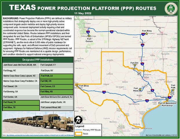
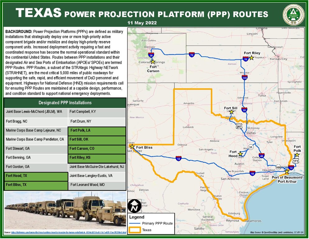
English: A subset of routes deemed important for U.S. national security, called Power Projection Platform (PPP) routes, is highlighted on this map primarily in the state of Texas and incidentally in the states of Louisiana, Oklahoma, Kansas, and Colorado. This is the original file retrieved on July 13, 2023. |
| Date | |
| Source | https://www.sddc.army.mil/sites/TEA/Functions/SpecialAssistant/HND_Publications/Texas%20-%20PPP%20Routes.pdf |
| Author | Military Surface Deployment and Distribution Command's Transportation Engineering Agency (SDDCTEA) |
Licensing[edit]
The attribution text in the document claims that the featured map was licensed from OpenStreetMap under a version of CC-BY-SA license; however, the document was produced nearly two years after the OpenStreetMap Foundation stopped placing its standard tile layer under the CC-BY-SA-2.0 license. In my opinion, it is therefore likely that the map is subject only to the terms of the Open Database License as a Produced Work rather than both ODbL and any CC-BY-SA. I hope this username is available. (talk)
| This work contains information from OpenStreetMap, which is made available under the Open Database License (ODbL).
The ODbL does not require any particular license for maps produced from ODbL data. Prior to 1 August 2020, map tiles produced by the OpenStreetMap Foundation were licensed under the CC-BY-SA-2.0 license. Maps produced by other people may be subject to other licences. |
This file is a work of a U.S. Army soldier or employee, taken or made as part of that person's official duties. As a work of the U.S. federal government, it is in the public domain in the United States.
|
 |
File history
Click on a date/time to view the file as it appeared at that time.
| Date/Time | Thumbnail | Dimensions | User | Comment | |
|---|---|---|---|---|---|
| current | 02:22, 14 July 2023 |  | 1,650 × 1,275 (3.47 MB) | I hope this username is available. (talk | contribs) | Uploaded a work by Military Surface Deployment and Distribution Command's Transportation Engineering Agency (SDDCTEA) from https://www.sddc.army.mil/sites/TEA/Functions/SpecialAssistant/HND_Publications/Texas%20-%20PPP%20Routes.pdf with UploadWizard |
You cannot overwrite this file.
File usage on Commons
The following 2 pages use this file: