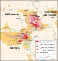
File:Tchernobyl radiation 1996.svg
From Wikimedia Commons, the free media repository
Jump to navigation
Jump to search

Size of this PNG preview of this SVG file: 568 × 600 pixels. Other resolutions: 227 × 240 pixels | 455 × 480 pixels | 727 × 768 pixels | 970 × 1,024 pixels | 1,940 × 2,048 pixels | 1,398 × 1,476 pixels.
Original file (SVG file, nominally 1,398 × 1,476 pixels, file size: 421 KB)
File information
Structured data
Captions
Captions
Add a one-line explanation of what this file represents
Summary[edit]
| DescriptionTchernobyl radiation 1996.svg |
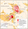
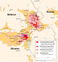
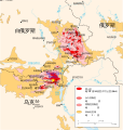
English: Map of the radiation hotspots of Cesium-137 in 1996 resulting from the Chernobyl nuclear power plant accident.
Français : État de la contamination au césium-137 en 1996 suite à l'accident de la centrale nucléaire de Tchernobyl. |
||
| Date | |||
| Source |
own work Based upon the map from the CIA Handbook of International Economic Statistics (1996) trough a scan from the site of The University of Texas at Austin (in Public Domain) |
||
| Author | of this SVG version : Sting | ||
| Permission (Reusing this file) |
|
||
| Other versions |
[edit]
|
This map was improved or created by the Wikigraphists of the Graphic Lab (fr). You can propose images to clean up, improve, create or translate as well. |
| This SVG file contains embedded text that can be translated into your language, using any capable SVG editor, text editor or the SVG Translate tool. For more information see: About translating SVG files. |
Licensing[edit]
I, the copyright holder of this work, hereby publish it under the following license:
This file is licensed under the Creative Commons Attribution-Share Alike 2.5 Generic license.
- You are free:
- to share – to copy, distribute and transmit the work
- to remix – to adapt the work
- Under the following conditions:
- attribution – You must give appropriate credit, provide a link to the license, and indicate if changes were made. You may do so in any reasonable manner, but not in any way that suggests the licensor endorses you or your use.
- share alike – If you remix, transform, or build upon the material, you must distribute your contributions under the same or compatible license as the original.
File history
Click on a date/time to view the file as it appeared at that time.
| Date/Time | Thumbnail | Dimensions | User | Comment | |
|---|---|---|---|---|---|
| current | 13:28, 17 April 2008 |  | 1,398 × 1,476 (421 KB) | Sting (talk | contribs) | Scale labels in text format |
| 12:17, 18 October 2007 |  | 1,398 × 1,476 (444 KB) | Sting (talk | contribs) | Correction of the data for the lower radiation level : right, I didn't pay attention, the source map has that error too | |
| 01:19, 5 February 2006 |  | 1,398 × 1,476 (442 KB) | Sting (talk | contribs) | Font type for "Tchernobyl" | |
| 00:48, 5 February 2006 |  | 1,398 × 1,476 (442 KB) | Sting (talk | contribs) | Text rendering correction | |
| 00:27, 5 February 2006 |  | 980 × 1,035 (442 KB) | Sting (talk | contribs) | Size of document correction | |
| 23:37, 4 February 2006 |  | 744 × 1,052 (441 KB) | Sting (talk | contribs) | {{en}} ''Note : this « svg » map is with French caption and can be used to create a version in another language. For an original map in English, see :'' en:Image:Chornobyl_radiation_map.jpg * '''Subject :''' Radiation hotspots of Cesium-137 in |
You cannot overwrite this file.
File usage on Commons
The following 19 pages use this file:
- User:Sting/Gallery: Regional maps
- File:Chernobyl radiation map 1996-ar.svg
- File:Chernobyl radiation map 1996-el.svg
- File:Chernobyl radiation map 1996-lt.svg
- File:Chernobyl radiation map 1996.svg
- File:Chernobyl radiation map 1996 ko.svg
- File:Chornobyl radiation 1996 (uk).svg
- File:Chornobyl radiation map.jpg
- File:Tchernobyl radiation 1996-be.svg
- File:Tchernobyl radiation 1996-de.svg
- File:Tchernobyl radiation 1996-es.svg
- File:Tchernobyl radiation 1996-it.svg
- File:Tchernobyl radiation 1996-pl.svg
- File:Tchernobyl radiation 1996-ru.svg
- File:Tchernobyl radiation 1996-ru be-x-old.svg
- File:Tchernobyl radiation 1996-ru sr.svg
- File:Tchernobyl radiation 1996.svg
- File:Tchernobyl radiation 1996 eo.svg
- Template:Other versions/Tchernobyl radiation 1996
File usage on other wikis
The following other wikis use this file:
- Usage on ar.wikipedia.org
- Usage on bat-smg.wikipedia.org
- Usage on bg.wikipedia.org
- Usage on ca.wikipedia.org
- Usage on de.wikipedia.org
- Usage on fr.wikipedia.org
- Catastrophe nucléaire de Tchernobyl
- Wikipédia:Atelier graphique/Cartes
- Conséquences sanitaires de la catastrophe de Tchernobyl
- Retombée radioactive
- Protection de l'environnement
- Utilisateur:Kastus
- Zone d'exclusion nucléaire
- Wikipédia:Oracle/semaine 23 2011
- Wikipédia:Oracle/semaine 19 2012
- Zone d'exclusion de Tchernobyl
- Environnement en Russie
- Environnement en Ukraine
- Environnement en Biélorussie
- Usage on oc.wikipedia.org
- Usage on so.wikipedia.org


