File:Shakemap Ecuador April 2016.jpg
Jump to navigation
Jump to search
Size of this preview: 456 × 599 pixels. Other resolutions: 183 × 240 pixels | 365 × 480 pixels | 762 × 1,001 pixels.
Original file (762 × 1,001 pixels, file size: 288 KB, MIME type: image/jpeg)
Captions
Captions
Add a one-line explanation of what this file represents
Summary[edit]
| Description |
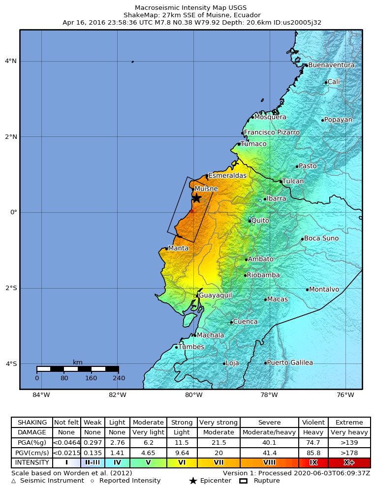
English: Shakemap for the 2016 Ecuador earthquake
Español: Mapa de intensidades sísmicas para el terremoto de Ecuador de 2016
Magyar: A 2016-os ecuadori földrengés rengéseinek térképe |
| Date | |
| Source | https://earthquake.usgs.gov/earthquakes/eventpage/us20005j32#shakemap |
| Author | United States Geological Survey |
Licensing[edit]
This image is in the public domain in the United States because it only contains materials that originally came from the United States Geological Survey, an agency of the United States Department of the Interior. For more information, see the official USGS copyright policy.
|
File history
Click on a date/time to view the file as it appeared at that time.
| Date/Time | Thumbnail | Dimensions | User | Comment | |
|---|---|---|---|---|---|
| current | 19:36, 25 June 2023 | | 762 × 1,001 (288 KB) | 4kolechia (talk | contribs) | added newer version |
| 19:23, 17 April 2016 |  | 2,125 × 2,480 (1.76 MB) | Kiwi128 (talk | contribs) | higher resolution version rendered from postscript file | |
| 16:07, 17 April 2016 |  | 612 × 717 (102 KB) | Skycycle (talk | contribs) | Update via USGS, new intensity and depth | |
| 00:39, 17 April 2016 |  | 612 × 717 (100 KB) | GroundControl01 (talk | contribs) | User created page with UploadWizard |
You cannot overwrite this file.
File usage on Commons
There are no pages that use this file.
File usage on other wikis
The following other wikis use this file:
- Usage on ar.wikipedia.org
- Usage on bg.wikipedia.org
- Usage on de.wikipedia.org
- Usage on en.wikipedia.org
- Usage on es.wikipedia.org
- Usage on es.wikinews.org
- Usage on fi.wikipedia.org
- Usage on fr.wikipedia.org
- Usage on hi.wikipedia.org
- Usage on hu.wikipedia.org
- Usage on hy.wikipedia.org
- Usage on id.wikipedia.org
- Usage on it.wikipedia.org
- Usage on ja.wikipedia.org
- Usage on ko.wikipedia.org
- Usage on ky.wikipedia.org
- Usage on la.wikipedia.org
- Usage on ms.wikipedia.org
- Usage on nl.wikipedia.org
- Usage on no.wikipedia.org
- Usage on ro.wikipedia.org
- Usage on ru.wikipedia.org
- Usage on ru.wikinews.org
- Usage on uk.wikipedia.org
- Usage on vi.wikipedia.org