Category:PD USGS
Jump to navigation
Jump to search
Subcategories
This category has the following 3 subcategories, out of 3 total.
Pages in category "PD USGS"
The following 2 pages are in this category, out of 2 total.
Media in category "PD USGS"
The following 200 files are in this category, out of 22,606 total.
(previous page) (next page)-
 "In My Day!" (18518488309).jpg 3,895 × 3,101; 6.28 MB
-
 "Lot's Wife" (15232457247).jpg 1,400 × 989; 1.03 MB
-
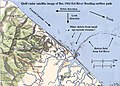 "Quill" satellite radar image of flooded Eel River outflow current.JPG 1,000 × 719; 123 KB
-
 "This means something. This is important" (19967592275).jpg 3,264 × 2,448; 2.32 MB
-
 (beetle), Back, Judelot Farm, Maryland 2014-10-20-14.30 (22640942662).jpg 5,347 × 3,361; 6.77 MB
-
 (Bright) Bees in Cars Front 2019-03-28-15.51.48 ZS PMax UDR (40548291263).jpg 3,606 × 2,755; 5.64 MB
-
 (Bright) Car Full of Bees Overhead 2019-03-28-16.01.37 ZS PMax UDR (33637501448).jpg 5,760 × 3,840; 11.64 MB
-
 (Fixed) Bees in Cars, Yellow, Overhead 2019-03-27-15.13.13 ZS PMax UDR (46598763235).jpg 5,782 × 3,696; 18.61 MB
-
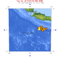
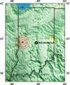
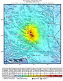
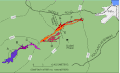
 +7 earthquakes around Van 1900-2011.jpg 410 × 568; 64 KB
-
 -174 -20 globe.jpg 146 × 146; 11 KB
-
 -Agapostemon Male ID Copy (30340711068).jpg 1,080 × 1,080; 1,009 KB
-
 -TBT - Cape Cod, Massachusetts (12220561204).jpg 1,400 × 965; 764 KB
-
-
 -TBT- Cheyenne, WY (10853524504).jpg 1,325 × 1,400; 1.04 MB
-
 -ThrowBackThursday- Little Annie (10724566925).jpg 5,246 × 2,800; 7.3 MB
-
 022srUSGSCyprusVia.jpg 758 × 512; 54 KB
-
 04 North Pole Wolf.jpg 1,180 × 790; 191 KB
-
 080406 0410 CCH L.jpg 1,200 × 397; 113 KB
-
 089srUSGSoffFoundation.jpg 752 × 512; 50 KB
-
 09 North Pole Wolf.jpg 1,180 × 793; 163 KB
-
 093srUSGSpinupFailure.jpg 749 × 512; 44 KB
-
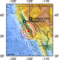
 0M5Waverly.jpg 1,200 × 1,200; 272 KB
-
 10-point divider - 000649-10 Pt Divider 01.JPG 2,019 × 2,636; 2.17 MB
-
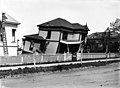
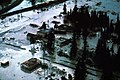
 100-Year Old Adobe Building Destroyed (4479274376).jpg 5,616 × 3,744; 4.15 MB
-
 1000 Mile Tree Weber Canyon 1869.jpg 758 × 700; 366 KB
-
 1000px-Production of oil shale.png 1,000 × 555; 100 KB
-
 105 -10.gif 504 × 497; 31 KB
-
 10x Nomada eye 2015-04-13-17.41.16 ZS PMax (16519118423).jpg 5,285 × 3,564; 13.73 MB
-
 110 -8 globe.jpg 146 × 146; 13 KB
-
 116 30 globe.jpg 146 × 146; 13 KB
-
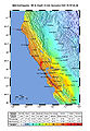
 122-38HaywardFault.jpg 568 × 549; 88 KB
-
 13 June 2011 Christchurch earthquake.png 552 × 671; 370 KB
-
 145 40 smallglobe.png 146 × 146; 7 KB
-
 145 40.png 439 × 499; 31 KB
-
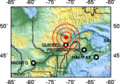
 1663 Charlevoix earthquake location.png 214 × 149; 24 KB
-
 17254 Grand Canyon Nat Park Historic River Photo (7304988964).jpg 1,024 × 1,142; 300 KB
-
 1755 Lisbon Earthquake Location no cap.jpg 329 × 400; 46 KB
-
 1755 Lisbon Earthquake Location.png 331 × 420; 100 KB
-
 1850s from Niagara Falls (25369570180).jpg 4,546 × 3,238; 1.67 MB
-
 1869 Windmill at North Platte Station (15090577757).jpg 1,400 × 943; 759 KB
-
 1870 Charlevoix earthquake epicenter.png 214 × 156; 25 KB
-
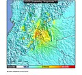
 1872 North Cascades Isoseismal Map.png 1,464 × 1,544; 508 KB
-

-
 1878GeologicMapofYellowstone.jpg 4,520 × 5,216; 6.24 MB
-
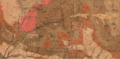
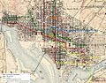 1888 WDC Streetcar Map.JPG 1,042 × 816; 326 KB
-
 1889 USGS Topographic Map of Brooklyn NY.jpg 4,804 × 5,996; 3.52 MB
-
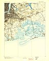
 1893 U. S. Geological Survey Map of Portsmouth Harbor.jpg 800 × 600; 178 KB
-
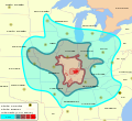
 19 August 2018 Lombok earthquake intensity map.png 1,700 × 1,984; 221 KB
-

-
 1902 USGS topo map of Baring, Washington.jpg 3,000 × 3,000; 3.94 MB
-
 1904 Bunker Hill Mine Stope Map.png 1,442 × 914; 1.1 MB
-
 1904BunkerHillMine Richmond(1) Stemwinder(6) Tunnels.png 632 × 894; 782 KB
-
 1904BunkerHillStopes.png 950 × 895; 2.28 MB
-
 1904BurkeIdaho Tiger-Poorman Hecla Mine shafts.png 1,210 × 891; 1.45 MB
-
 1904HerculesSilverMineIdaho.png 1,201 × 826; 1.34 MB
-
 1904MullanIdaho.png 1,283 × 897; 1.48 MB
-
 1904SullivanMineIdaho.png 656 × 895; 809 KB
-
 1904WallaceIdaho.png 1,286 × 891; 1.45 MB
-
 1906 Boatwright intensity.jpg 612 × 884; 539 KB
-
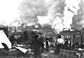
 1906 earthquake train.jpg 1,149 × 802; 263 KB
-
 1906 loma prieta.png 733 × 549; 8 KB
-
 1906 San Francisco Earthquake (15104435834).jpg 4,625 × 3,245; 1.34 MB
-
 1906 San Francisco Earthquake (22778070880).jpg 4,049 × 2,957; 1.69 MB
-
 1906 San Francisco earthquake seismograph.png 674 × 508; 7 KB
-
 1907BurkeCanyonIdaho geologicmap.png 1,819 × 899; 4.72 MB
-
 1907BurkeIdaho geologic map.png 1,819 × 898; 4.71 MB
-
 1907KelloggIdaho geologicmap.png 1,461 × 876; 3.8 MB
-
 1907MullanIdaho geologicmap.png 1,819 × 898; 4.77 MB
-
 1907MurrayIdaho geologicmap.png 1,821 × 895; 4.76 MB
-
 1907OsburnIdaho geologicmap.png 1,819 × 896; 4.78 MB
-
 1907SilverValleyIdaho geologicmap.png 1,820 × 897; 4.65 MB
-

-
 1908* Edgartown Light area USGS Topo Map.png 1,174 × 952; 1.85 MB
-
 1909 Wabash valley earthquake map.png 250 × 299; 56 KB
-
 1915 pleasant valley earthquake map.png 331 × 466; 114 KB
-
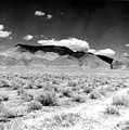 1915 Pleasant Valley earthquake scarp.jpg 693 × 700; 340 KB
-
 1915 USGS Topo Prosser.jpg 1,526 × 1,017; 909 KB
-
 1916 Irondale epicenter map.png 331 × 426; 96 KB
-
 1918-10-11 M 7.1 - Puerto Rico region.jpg 612 × 718; 61 KB
-
 1925 Charlevoix-Kamouraska earthquake epicenter.png 214 × 156; 25 KB
-
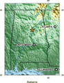
 1925 Three Forks, MT earthquake damage.png 790 × 451; 329 KB
-
 1928 USGSexcerptOLGA.jpg 2,295 × 1,167; 686 KB
-
 1931 Valentine, Texas earthquake ShakeMap.jpg 787 × 1,014; 370 KB
-
 1933 Long Beach earthquake damage 1.jpg 1,400 × 1,002; 881 KB
-
 1935 Dien Bien, Vietnam earthquake.png 1,009 × 652; 976 KB
-
 1935 Timiskaming earthquake epicenter.png 214 × 149; 24 KB
-
 1936 State Line earthquake isoseismal map.png 769 × 813; 228 KB
-
 1940 12 20 isoseismal map.PNG 646 × 531; 59 KB
-
 1942 topographic map of Salem USGS.jpg 3,056 × 3,691; 4.62 MB
-
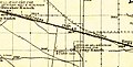
 1943 US 9 end USGS map.jpg 314 × 356; 55 KB
-
 1944 Cornwall Massena Isoseismal Map.png 651 × 530; 124 KB
-
 1946 Vancouver Island Earthquake.png 182 × 139; 23 KB
-
 1946DominicanRepublic.png 214 × 108; 16 KB
-
 1950 Calama earthquake.jpg 906 × 1,079; 414 KB
-
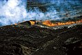
 1950 eruption of Mauna Loa.jpg 445 × 333; 53 KB
-
 1952 Kern County earthquake - Damaged school.tif 1,000 × 667; 934 KB
-
 1953 Ionian earthquake shakemap.jpg 787 × 1,013; 285 KB
-
 1954-OrientPointLight-USGSMap.jpg 1,015 × 693; 160 KB
-
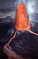
 1959 eruption of Kilauea Volcano.jpg 3,596 × 2,363; 10.95 MB
-
 1960 02 29 Agadir earthquake.png 331 × 273; 61 KB
-
 1960 05 22 loc.png 338 × 416; 102 KB
-
 1960 Valdivia earthquake.jpg 822 × 1,084; 325 KB
-
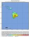
 1960-Chilean-tsunami-Hilo-HI-USGS.jpg 766 × 612; 98 KB
-

-

-

-
 1962 Buin Zahra earthquake intensity.jpg 787 × 965; 371 KB
-
 1962 Topographical Map of Abandoned Bong Air Force Base.jpg 962 × 749; 597 KB
-
 1964 Alaska Quake Kodiak Before and After.jpg 2,293 × 3,628; 4.61 MB
-
 1964 Alaska Quake Kodiak-After.jpg 2,288 × 1,573; 1.95 MB
-
 1964 Alaska Quake Kodiak-Before.jpg 2,288 × 1,573; 1.93 MB
-
 1964 Alaska Quake L Street Apartments.jpg 2,408 × 3,614; 2.91 MB
-
 1964 Alaska Quake L Street Slide.jpg 3,936 × 2,571; 3.95 MB
-
 1964 Alaska Quake Penney Bldg.jpg 3,582 × 2,376; 3.11 MB
-
 1964 Alaska Quake Portage Townsite.jpg 3,592 × 2,401; 5.14 MB
-
1964 Quake- The Great Alaska Earthquake.webm 11 min 37 s, 1,920 × 1,080; 144.17 MB
-
 1965 Rat Islands earthquake shakemap.jpg 612 × 719; 61 KB
-
 1967 Aratoca earthquake ShakeMap.jpg 864 × 792; 200 KB
-
 1967 Guichi Downtown.tif 5,589 × 3,738; 59.79 MB
-
 1967 Neiva earthquake ShakeMap.jpg 864 × 792; 229 KB
-
 1967-USGSTopoMapExcerpt.jpg 628 × 393; 96 KB
-
 1967年的三道桥.png 827 × 578; 575 KB
-
 1968 Casiguran earthquake.jpg 612 × 717; 86 KB
-
 1968 Illinois earthquake.gif 644 × 615; 63 KB
-
 1968 Illinois earthquake.svg 394 × 360; 175 KB
-
 1968 Sulawesi earthquake - Shakemap.jpg 612 × 717; 96 KB
-
 1968 The main townships of Fuzhou, Fubei, and Shangdongdu.tif 5,712 × 4,912; 26.76 MB
-
 1968 USGS flood map Bellows Air Force Station.jpg 983 × 750; 397 KB
-
 1969 Santa Barbara Oil Spill CA.jpg 617 × 482; 44 KB
-
 1970 Ancash earthquake intensity.jpg 822 × 1,084; 307 KB
-
 1970 Bahía Solano earthquake ShakeMap.jpg 864 × 792; 194 KB
-
 1970 Chocó earthquake ShakeMap.jpg 864 × 792; 144 KB
-
 1970 New Guinea earthquake - ShakeMap.jpg 612 × 717; 104 KB
-
 1970 Peru–Ecuador earthquake intensity.jpg 777 × 1,011; 305 KB
-
 1970 Tonghai earthquake.png 214 × 156; 25 KB
-
 1970年代石林县城-路南石林卫星影像.jpg 4,201 × 4,545; 7.01 MB
-
 1970年代石林县城卫星影像.jpg 1,951 × 1,774; 1.25 MB
-
 1971 Geologic Map of the Near Side of the Moon Cropped.png 4,095 × 4,590; 26.48 MB
-
 1971 Illapel earthquake.jpg 612 × 716; 168 KB
-
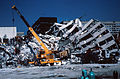
 1971 San Fernando highway overpass collapse.jpg 700 × 464; 456 KB
-
 1972Nicaraguaquake2.jpg 301 × 412; 133 KB
-
 1972Nicaraguaquake3.jpg 313 × 412; 147 KB
-
 1972Nicaraguaquake4.jpg 252 × 363; 86 KB
-
 1972Nicaraguaquake5.jpg 318 × 243; 92 KB
-
 1975 Chocó earthquake ShakeMap.jpg 864 × 792; 144 KB
-
 1975 Coquimbo earthquake.jpg 612 × 722; 157 KB
-
 1975 Mauna Loa eruption fountains.jpg 900 × 603; 83 KB
-
 1975 Mauna Loa lava cascades.jpg 777 × 559; 76 KB
-
 1975 Pavlof volcano eruption, Alaska (1182883978).jpg 2,971 × 2,011; 921 KB
-
 1976 papua indonesia earthquake intensity map.jpg 612 × 719; 176 KB
-
 1977 Geologic Map of San Juan Quadrangle, Puerto Rico.jpg 2,837 × 2,548; 2.07 MB
-
 1977 Vrancea earthquake.jpg 612 × 710; 218 KB
-
 1978 Tabas earthquake shakemap.jpg 785 × 1,001; 409 KB
-
 19780728-南湖机场旧影像.png 1,292 × 1,548; 2.28 MB
-
 1979 El Cairo earthquake ShakeMap.jpg 864 × 792; 191 KB
-
 1979 Norcia earthquake.jpg 806 × 1,003; 391 KB
-
 1979 Tumaco earthquake ShakeMap.jpg 864 × 792; 143 KB
-
 1979-USGS-jayneshill.JPG 793 × 754; 206 KB
-
 1980 El Asnam earthquake ShakeMap.jpg 612 × 719; 101 KB
-
 1980 St. Helens ashmap.png 808 × 550; 11 KB
-
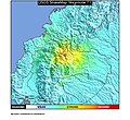
 19801123 183453 irpinia quake intensity.jpg 612 × 718; 115 KB
-
 1981-06-11 Golbaf, Iran earthquake shakemap.jpg 785 × 1,001; 372 KB
-
 1981-07-28 Sirch, Iran earthquake shakemap.jpg 771 × 1,001; 378 KB
-
 1983 Guinea earthquake intensity map.jpg 612 × 717; 136 KB
-
 1983 Kaoiki earthquake.jpg 787 × 997; 151 KB
-
 1983 Map of the south portion of the Jefferson National Forest in southwest Virginia.jpg 13,192 × 9,100; 16.43 MB
-
 1983californiamap.png 179 × 181; 24 KB
-
 1984 Cachar earthquake.jpg 612 × 718; 142 KB
-
 1984 Eruption (23125250919).jpg 502 × 768; 88 KB
-
 1984 Mauna Loa lava flows.gif 539 × 327; 11 KB
-
 1985 Lago Rapel earthquake.jpg 612 × 716; 169 KB
-
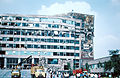
 1985 Mexico Earthquake - Building collapsed.jpg 1,368 × 923; 1.46 MB
-
 1985 Mexico Earthquake - Collapsed General Hospital.jpg 3,502 × 2,392; 13.07 MB
-
 1985 Mexico Earthquake - Damaged Social Security Hospital.jpg 462 × 700; 406 KB
-
 1985 Mexico Earthquake - Damages in eight-story building collapsed.jpg 925 × 1,400; 1.62 MB
-
 1985 Mexico Earthquake - Eight-story building collapsed 2.jpg 3,550 × 2,336; 9.39 MB
-
 1985 Mexico Earthquake - Eight-story building collapsed.jpg 3,678 × 2,432; 9.72 MB
-
 1985 Mexico Earthquake - Hotel Continental.jpg 3,582 × 2,376; 8.5 MB
-
 1985 Mexico Earthquake - Ministry of Telecommunications and Transportation building 3.jpg 3,550 × 2,368; 9.06 MB
-

-

-
 1985 Mexico Earthquake - Ministry of Telecommunications and Transportation building2.jpg 3,566 × 2,328; 8.68 MB
-

-
 1985 Mexico Earthquake - Nuevo Leon building 2.jpg 3,598 × 2,368; 10.46 MB
-
 1985 Mexico Earthquake - Nuevo Leon building.jpg 2,432 × 3,630; 10.69 MB
-
 1985 Mexico Earthquake - Pina Suarez Apartment Complex (2).jpg 922 × 1,400; 1.33 MB
-
 1985 Mexico Earthquake - Pina Suarez Apartment Complex (3).jpg 1,400 × 929; 1.66 MB
-
 1985 Mexico Earthquake - Pina Suarez Apartment Complex.jpg 1,392 × 928; 1.11 MB
-
 1985 Mexico Earthquake - Pino Suarez Apartment Complex damage.jpg 2,376 × 3,606; 11.68 MB
-
 1985 Mexico Earthquake 19850919 1317 UTC loc.jpg 612 × 721; 156 KB
-
 1985 Mexico Earthquake 21091985 0137 UTC loc.jpg 612 × 720; 171 KB
-
 1985 Nahanni earthquakes.png 179 × 181; 24 KB
-
 1985 Santiago earthquake.jpg 612 × 720; 157 KB
-
 1986 Hualien earthquake intensity map.jpg 612 × 723; 109 KB
-
 1986 Kalamata Greece earthquake shakemap.jpg 797 × 1,001; 282 KB
-
 1987 Ecuador-Colombia earthquakes ShakeMap.jpg 864 × 792; 205 KB
-
 1987 Iquique earthquake.jpg 612 × 720; 162 KB
-
 1988 Lancang-Gengma Shakemap.jpg 787 × 993; 507 KB
-
 1988 Saguenay earthquake location.png 214 × 149; 24 KB
-
 1988 Spitak earthquake.jpg 864 × 792; 348 KB
.jpg)
.jpg)

.jpg)
,_Back,_Judelot_Farm,_Maryland_2014-10-20-14.30_(22640942662).jpg)
_Bees_in_Cars_Front_2019-03-28-15.51.48_ZS_PMax_UDR_(40548291263).jpg)
_Car_Full_of_Bees_Overhead_2019-03-28-16.01.37_ZS_PMax_UDR_(33637501448).jpg)
_Bees_in_Cars,_Yellow,_Overhead_2019-03-27-15.13.13_ZS_PMax_UDR_(46598763235).jpg)


.jpg)
.jpg)
.jpg)
.jpg)
.jpg)


.jpg)


.jpg)


.jpg)


.jpg)
.jpg)


_Stemwinder(6)_Tunnels.png)


.jpg)
.jpg)


_-_landmark_Lunar_map%5E_-_Geographicus_-_LunarRays-usgs-1961.jpg)
_-_landmark_Lunar_map%5E_-_Geographicus_-_PhotogeologicMoon-usgs-1961.jpg)
_-_landmark_Lunar_map%5E_-_Geographicus_-_MoonPhysical-usgs-1961.jpg)


.jpg)


.jpg)


.jpg)
.jpg)


