File:Schwarzenberg Bersbuch Panorama 1.jpg
Jump to navigation
Jump to search

Size of this preview: 800 × 385 pixels. Other resolutions: 320 × 154 pixels | 640 × 308 pixels | 1,024 × 493 pixels | 1,280 × 616 pixels | 2,560 × 1,232 pixels | 5,856 × 2,819 pixels.
Original file (5,856 × 2,819 pixels, file size: 1.85 MB, MIME type: image/jpeg)
Captions
Captions
Add a one-line explanation of what this file represents
This image has been assessed using the Quality image guidelines and is considered a Quality image.
|
| Description |
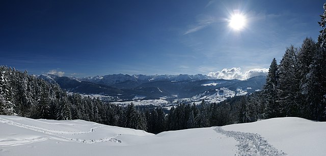
Deutsch: 8 Bild-Panoramablick unter dem Brüggelekopf in Alberschwende auf der Berchtoldshöhe : Im Tal Ortsteile von Bersbuch und Schwarzenberg. Das Gebirge links beginnend: Berge des Lechquellengebirges und des Bregenzerwaldgebirges. Im einzelnen v.l.n.r.: die Winterstaude 1877m, Tristenkopf 1.741m, Vordere Niedere 1.586m, Baumgartenalpe 1624m, Diedamskopf 2090m, Üntschenspitze 2135m, Juppenspitze 2412m, Mohnenfluh 2542m, Hochkünzelspitze 2397m, Niedere Künzelspitze 2156m, Kanisfluh 2044m, Klipperen 2066m, Damülser Mittagsspitze 2095m, Hohes Licht (Damüls) 2009m, Hochblanken 2068m, Ragazer Blanken 2051m, Sünser Spitze 2061m, die Mellauer Hangspitze 1746m, das Dornbirner Firstgebirge mit dem Leuenkopf. Die Häusersiedlung rechts oben (unter den Wolken) gehören zum Klausberg-Hinterstück und Klausberg-Vorderstück. Für Kenner gut getarnt am Waldrand die Lustenauer Hütte. |
| Date | |
| Source | Own work |
| Author | böhringer friedrich |
| Permission (Reusing this file) |
I, the copyright holder of this work, hereby publish it under the following license: This file is licensed under the Creative Commons Attribution-Share Alike 2.5 Generic license.
|
| Other versions |
|
| Camera location | | View this and other nearby images on: OpenStreetMap |
|---|
This Photo was taken by Böhringer Friedrich.
|
Feel free to use my photos, but please mention me as the author and if you want send me a message. or (rufre@lenz-nenning.at) |
File history
Click on a date/time to view the file as it appeared at that time.
| Date/Time | Thumbnail | Dimensions | User | Comment | |
|---|---|---|---|---|---|
| current | 21:36, 27 February 2009 | | 5,856 × 2,819 (1.85 MB) | Böhringer (talk | contribs) | {{Information |Description= {{de| 8 Bild-Panoramablick unter dem Brüggelekopf in Alberschwende auf der Berchtoldshöhe : Im Tal Ortsteile von Bersbuch und [[:de:Schwarzenberg (Vorarlberg)|Sch |
You cannot overwrite this file.
File usage on Commons
The following 4 pages use this file:
File usage on other wikis
The following other wikis use this file:
- Usage on fr.wikipedia.org