File:Nouveau plan de Paris divisé en 12 arrondissements - Norman B. Leventhal Map Center.tif
Jump to navigation
Jump to search

Size of this JPG preview of this TIF file: 800 × 544 pixels. Other resolutions: 320 × 218 pixels | 640 × 435 pixels | 1,024 × 696 pixels | 1,280 × 870 pixels | 2,560 × 1,740 pixels | 6,564 × 4,462 pixels.
Original file (6,564 × 4,462 pixels, file size: 83.82 MB, MIME type: image/tiff)
Captions
Captions
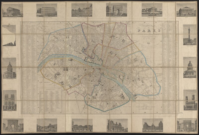
An old map of Paris, France.
Summary[edit]
| Title |
Nouveau plan de Paris divisé en 12 arrondissements |
||||||||||||||||||||||||||
| Description |
English: An old map of Paris, France. |
||||||||||||||||||||||||||
| Date | |||||||||||||||||||||||||||
| Source | Norman B. Leventhal Map Center | ||||||||||||||||||||||||||
| Creator |
Alexandre Vuillemin (1812- ) |
||||||||||||||||||||||||||
| Geotemporal data | |||||||||||||||||||||||||||
| Map location | Paris | ||||||||||||||||||||||||||
| Scale | Scale approximately 1:17,500 | ||||||||||||||||||||||||||
| Georeferencing | If inappropriate please set warp_status = skip to hide. | ||||||||||||||||||||||||||
| Bibliographic data | |||||||||||||||||||||||||||
| Language | French | ||||||||||||||||||||||||||
| Publisher |
[Paris] : Chez Garnier |
||||||||||||||||||||||||||
| Archival data | |||||||||||||||||||||||||||
| Collection |
|
||||||||||||||||||||||||||
| Dimensions | 40 x 68 cm | ||||||||||||||||||||||||||
| Medium | 1 map : hand-colored | ||||||||||||||||||||||||||
| Inscriptions | dressée par Vuillemin ; gravé sur acier par Alès ; écrit par Bénard | ||||||||||||||||||||||||||
| Notes |
Includes index. 18 illustrations of buildings in margins. |
||||||||||||||||||||||||||

Licensing[edit]
|
This work is in the public domain in its country of origin and other countries and areas where the copyright term is the author's life plus 100 years or fewer. | |
| This file has been identified as being free of known restrictions under copyright law, including all related and neighboring rights. | |
File history
Click on a date/time to view the file as it appeared at that time.
| Date/Time | Thumbnail | Dimensions | User | Comment | |
|---|---|---|---|---|---|
| current | 17:42, 21 December 2019 |  | 6,564 × 4,462 (83.82 MB) | Paris 16 (talk | contribs) | User created page with UploadWizard |
You cannot overwrite this file.
File usage on Commons
There are no pages that use this file.