File:North Dakota South Dakota Level III and Level IV ecoregions USEPA.pdf
Jump to navigation
Jump to search

Size of this JPG preview of this PDF file: 533 × 600 pixels. Other resolutions: 213 × 240 pixels | 427 × 480 pixels | 683 × 768 pixels | 910 × 1,024 pixels | 1,820 × 2,048 pixels | 3,600 × 4,050 pixels.
Original file (3,600 × 4,050 pixels, file size: 977 KB, MIME type: application/pdf)
Captions
Captions
Add a one-line explanation of what this file represents
Summary[edit]
| Description |
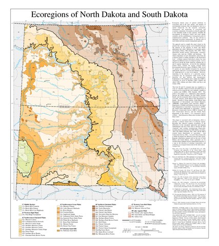
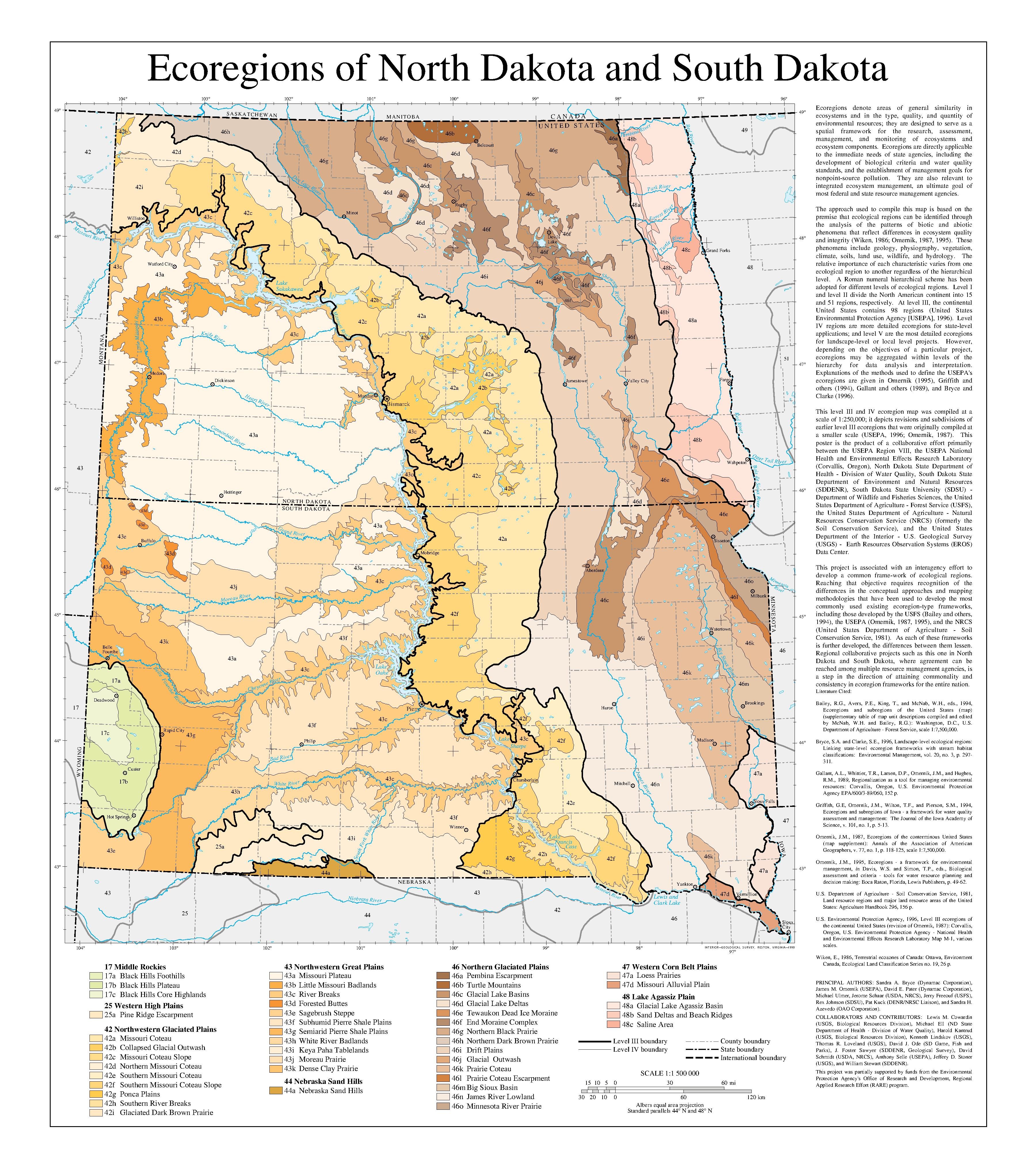
English: Map of Level III and Level IV ecoregions in North Dakota and South Dakota, as defined by the U.S. Environmental Protection Agency. |
| Source | ftp://newftp.epa.gov/EPADataCommons/ORD/Ecoregions/nd/ndsd_eco.pdf |
| Author | Sandra A. Bryce, James M. Omernik, David E. Pater, Michael Ulmer, Jerome Schaar, Jerry Freeouf, Rex Johnson, Pat Kuck, and Sandra H. Azevedo |
This image (or other media) is a work of an Environmental Protection Agency employee, taken or made as part of that person's official duties. As works of the U.S. federal government, all EPA images are in the public domain.
|
||
File history
Click on a date/time to view the file as it appeared at that time.
| Date/Time | Thumbnail | Dimensions | User | Comment | |
|---|---|---|---|---|---|
| current | 13:54, 27 September 2019 |  | 3,600 × 4,050 (977 KB) | TimK MSI (talk | contribs) | {{Information |description ={{en|1=Map of Level III and Level IV ecoregions in North Dakota and South Dakota, as defined by the U.S. Environmental Protection Agency.}} |date = |source =ftp://newftp.epa.gov/EPADataCommons/ORD/Ecoregions/nd/ndsd_eco.pdf |author =Sandra A. Bryce, James M. Omernik, David E. Pater, Michael Ulmer, Jerome Schaar, Jerry Freeouf, Rex Johnson, Pat Kuck, and Sandra H. Azevedo }} {{PD-USGov-EPA}} Category:Maps of EPA ecoregions [[Category:M... |
You cannot overwrite this file.
File usage on Commons
There are no pages that use this file.