File:Missolonghi siege general map-fr.jpg
Jump to navigation
Jump to search
Size of this preview: 500 × 600 pixels. Other resolutions: 200 × 240 pixels | 400 × 480 pixels | 640 × 768 pixels | 853 × 1,024 pixels | 1,400 × 1,680 pixels.
Original file (1,400 × 1,680 pixels, file size: 632 KB, MIME type: image/jpeg)
Captions
Captions
Add a one-line explanation of what this file represents
Summary[edit]
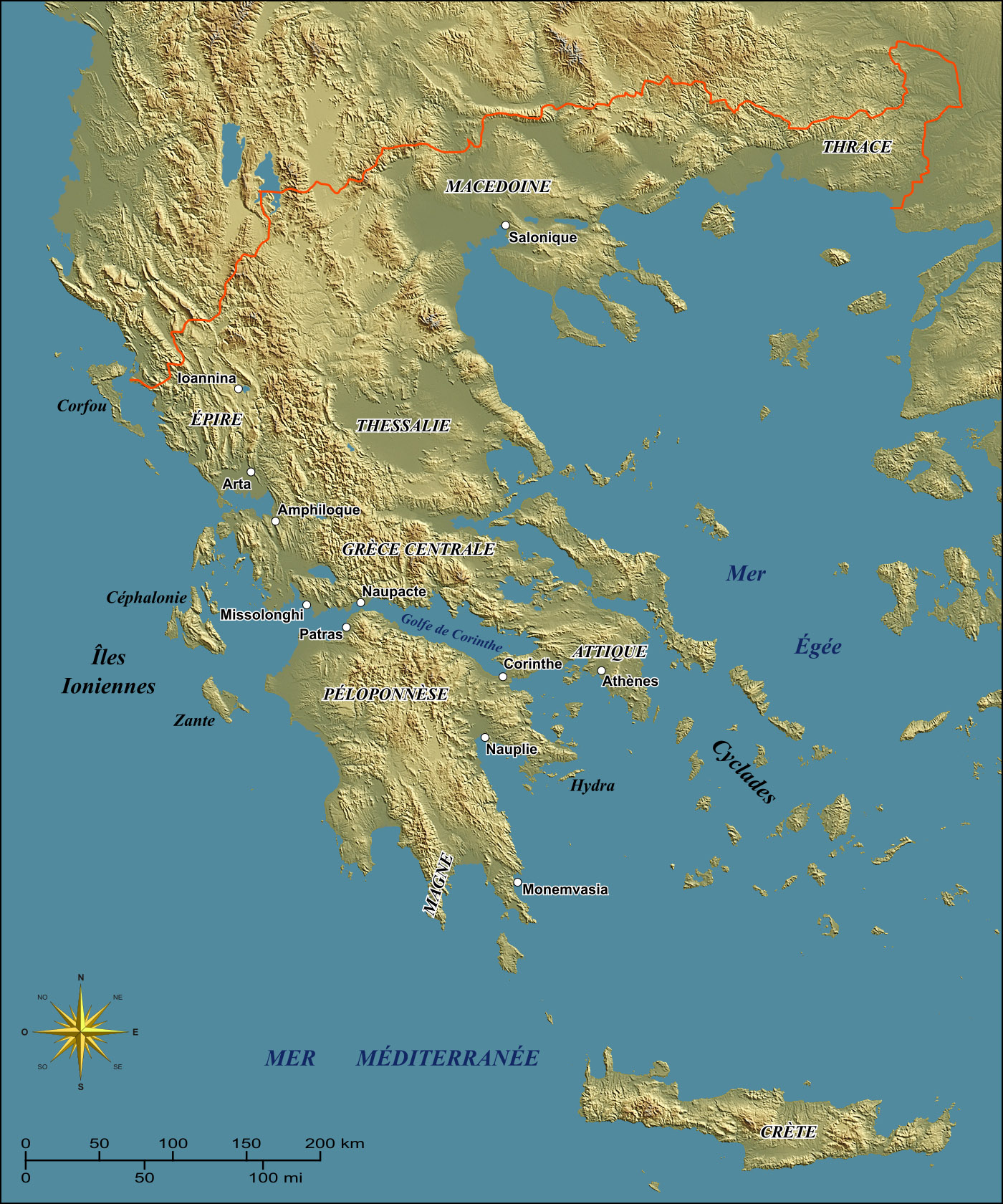
| Description | General map of Greece to illustrate the Siege of Missolonghi in the 1820's during the Greek War of Independence. |
| Date | |
| Source |
Own work ; Background map : NASA Shuttle Radar Topography Mission (SRTM3 v.2) (public domain) edited with 3DEM from Visualization Software LLC created by Richard Horne (perspectives corrected) (lightning position : 45° N-E ; azimuth 50°) ; References used for the Beotian lakes as they were during the 19th century : Gasp. G. Mistardis, Recherches (hydrogéologiques) dans la région des lacs karstiques béotiens (École des Mines de Paris) ; Compass rose : Image:Brújula.svg (modified) created by Serg!o under GFDL. |
| Author | Eric Gaba (Sting) |
| Permission (Reusing this file) |
GFDL + CC-BY-SA |
Français : * Sujet : Carte générale de la Grèce destinée à illustrer l'épisode du siège de Missolonghi dans les années 1820 durant la guerre d'indépendance grecque ;
- Source : Réalisation personnelle ;
- Fond de carte : NASA Shuttle Radar Topography Mission (SRTM3 v.2) (domaine public) édité avec 3DEM de Visualization Software LLC créé par Richard Horne (perspectives corrigées) (éclairage : 45° N-E ; azimut 50°) ;
- Référence utilisée pour le tracé des lacs en Béotie tels que durant le XIXe siècle : Gasp. G. Mistardis, Recherches (hydrogéologiques) dans la région des lacs karstiques béotiens (École des Mines de Paris) ;
- Rose des vents : Image:Brújula.svg (modifiée) créée par Serg!o sous GFDL ;
- Auteur : Eric Gaba (fr:Sting) ;
- Date : Février 2007 ;
Licensing[edit]
I, the copyright holder of this work, hereby publish it under the following licenses:

|
Permission is granted to copy, distribute and/or modify this document under the terms of the GNU Free Documentation License, Version 1.2 or any later version published by the Free Software Foundation; with no Invariant Sections, no Front-Cover Texts, and no Back-Cover Texts. A copy of the license is included in the section entitled GNU Free Documentation License. |
| This file is licensed under the Creative Commons Attribution-Share Alike 3.0 Unported license. | ||
| ||
| This licensing tag was added to this file as part of the GFDL licensing update. |
This file is licensed under the Creative Commons Attribution-Share Alike 2.5 Generic, 2.0 Generic and 1.0 Generic license.
- You are free:
- to share – to copy, distribute and transmit the work
- to remix – to adapt the work
- Under the following conditions:
- attribution – You must give appropriate credit, provide a link to the license, and indicate if changes were made. You may do so in any reasonable manner, but not in any way that suggests the licensor endorses you or your use.
- share alike – If you remix, transform, or build upon the material, you must distribute your contributions under the same or compatible license as the original.
You may select the license of your choice.
File history
Click on a date/time to view the file as it appeared at that time.
| Date/Time | Thumbnail | Dimensions | User | Comment | |
|---|---|---|---|---|---|
| current | 02:30, 27 February 2007 | | 1,400 × 1,680 (632 KB) | Sting (talk | contribs) | {{Information| |Description=General map of Greece to illustrate the Siege of Missolonghi in the 1820's during the Greek War of Independence. |Source= Own work ;<br/>Background map : [http://ww |
You cannot overwrite this file.
File usage on Commons
The following page uses this file:
File usage on other wikis
The following other wikis use this file:
- Usage on hu.wikipedia.org
- Usage on it.wikipedia.org