File:Map no. III - (to accompany A bill in the chancery of New-Jersey, at the suit of John, Earl of Stair ... against Benjamin Bond). NYPL433624.tiff
Jump to navigation
Jump to search

Size of this JPG preview of this TIF file: 800 × 376 pixels. Other resolutions: 320 × 150 pixels | 640 × 300 pixels | 1,024 × 481 pixels | 1,280 × 601 pixels | 2,560 × 1,202 pixels | 4,942 × 2,320 pixels.
Original file (4,942 × 2,320 pixels, file size: 32.81 MB, MIME type: image/tiff)
Captions
Captions
Add a one-line explanation of what this file represents
Summary[edit]
| Description | Map no. III : [to accompany A bill in the chancery of New-Jersey, at the suit of John, Earl of Stair ... against Benjamin Bond].; Lawrence H. Slaughter Collection of English maps, charts, globes, books and atlases / Atlases / A bill in the chancery of New-Jersey, at the suit of John earl of Stair, and others, proprietors of the eastern-division of New-Jersey; against Benjamin Bond. and some other persons of Elizabeth-Town, distinguished by the name of the Clinker lot right men. With three large maps, done from copper-plates. To which is added; the publications of the Council of proprietors of East New-Jersey, and Mr. Nevill's speeches to the General assembly, concerning the riots committed in New-Jersey, and the pretences of the rioters, and their seducers. These papers will give a better light into the history and constitution of New-Jersey, than any thing hitherto published, the matters whereof have been chiefly collected from records. Published by subscription: | |||||||||||||||||||||||
| Notes | Covers the area around Elizabeth, New Jersey between the Raritan and the Passaic Rivers. ''Note 2.'') Includes decorative cartouche. ''Note 3.'') Lawrence H. Slaughter Collection ; 258. ''Note 4.'') Relief shown pictorially. ''Note 5.'') Shows property lines, lot numbers, and some owners' names. ''Note 6.'') "Engrav'd and printed by James Turner near the Town House Boston ..." | |||||||||||||||||||||||
| Catalogue call number | Map Div. 97-6235 (Map no. III) [In LHS 4005] | |||||||||||||||||||||||
| Item physical description | 1 map ; 29 x 62 cm. folded to 35 x 21 cm. | |||||||||||||||||||||||
| Standard reference | Sabin 5378; Evans 6021; Church 961 | |||||||||||||||||||||||
| Date | ||||||||||||||||||||||||
| Source |
http://digitalgallery.nypl.org/nypldigital/dgkeysearchdetail.cfm?imageID=433624
|
|||||||||||||||||||||||
| Author | ||||||||||||||||||||||||
| Permission (Reusing this file) |
From The Lionel Pincus and Princess Firyal Map Division. http://maps.nypl.org
|
|||||||||||||||||||||||
| Source description | 124, 11 p., 2 ., 13-39 p., 1 . 3 fold. maps. 35.5 cm. | |||||||||||||||||||||||
| Location | Stephen A. Schwarzman Building / The Lionel Pincus and Princess Firyal Map Division | |||||||||||||||||||||||
| Digital item published | 2-3-2004; updated 1-9-2012 | |||||||||||||||||||||||
| Digital ID | 433624 | |||||||||||||||||||||||

The making of this file was supported by Wikimedia UK.
To see other files made with the support of Wikimedia UK, please see the category Supported by Wikimedia UK.
|
File history
Click on a date/time to view the file as it appeared at that time.
| Date/Time | Thumbnail | Dimensions | User | Comment | |
|---|---|---|---|---|---|
| current | 17:47, 1 June 2021 |  | 4,942 × 2,320 (32.81 MB) | Zeete (talk | contribs) | Cropped 17 % horizontally, 40 % vertically using CropTool with precise mode. |
| 14:03, 1 June 2021 |  | 5,939 × 3,848 (65.39 MB) | SteinsplitterBot (talk | contribs) | Bot: Image rotated by 270° | |
| 07:19, 10 May 2014 | 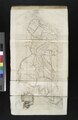 | 3,848 × 5,939 (65.39 MB) | Fæ (talk | contribs) | GWToolset: Creating mediafile for Fæ. Tranche 4 -12906 reload @07:10 BST, 10 May 2014 |
You cannot overwrite this file.
File usage on Commons
There are no pages that use this file.