File:Map.rep.arg.1883.jpg
Original file (4,413 × 3,569 pixels, file size: 1.94 MB, MIME type: image/jpeg)
Captions
Captions
| This media file has been protected because of a high likeihood of counter-productive edit warring.. Please discuss changes on the talk page or request unprotection. |
Summary
| Description |
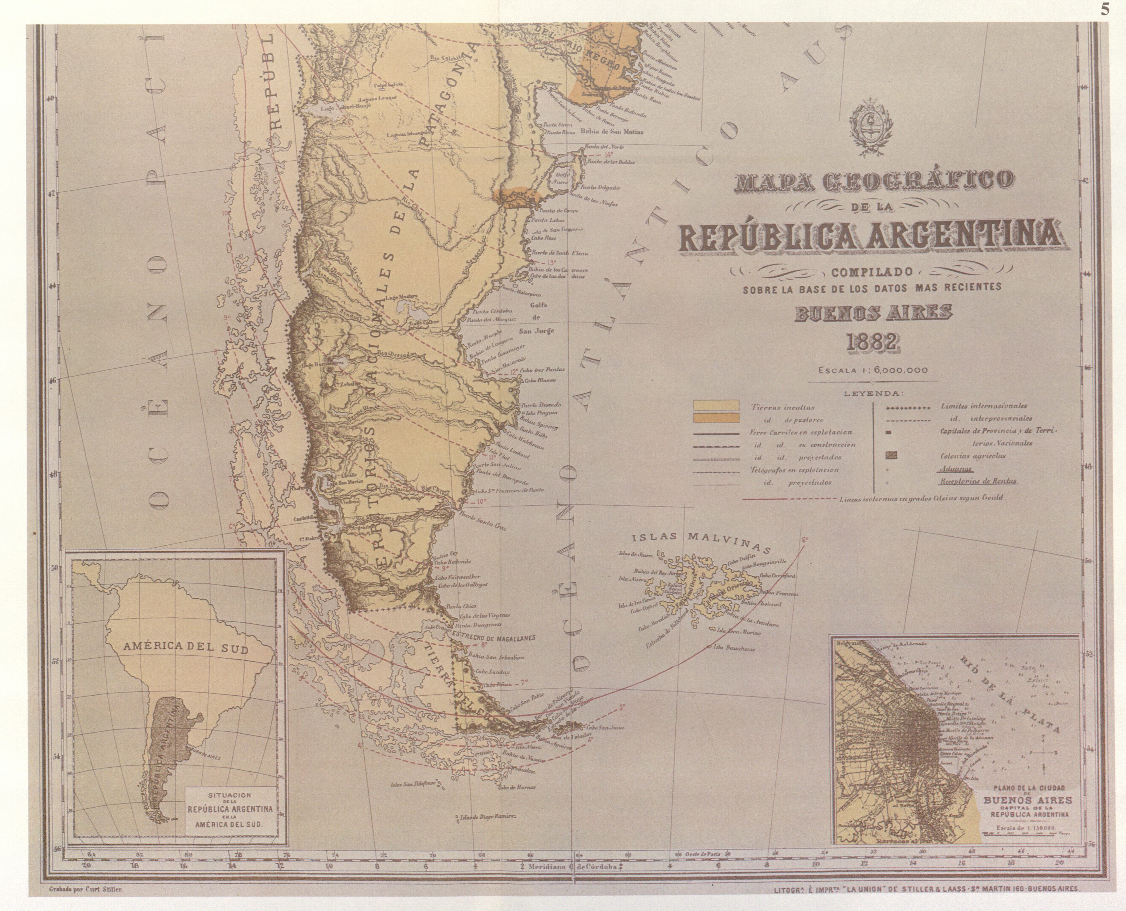
Partial view of the Latzina map of 1882. See [1]. The Latzina map of 1882 proved to be significant in the ICJ case between Argentina and Chile over the disputed Beagle Channel islands, since the disputed islands are shown as Chilean territory. It was created under the auspices of Señor Irigoyen, who had been previously responsible for negotiating the Boundary Treaty of 1881 with Chile. Due to his involvement, the significance of showing the islands as Chilean was deemed by the ICJ as a direct representation of Irigoyen's view of the boundaries between the two countries. |
|||||
| Date | ||||||
| Source | Relaciones chileno-argentinas, la controversia del Canal Beagle : una selección cartográfica / Chilean-Argentine relations, the Beagle Channel controversy : a cartographical selection, printed by Atar, Geneva, Switzerland, 1979. | |||||
| Author | Lith. by Curt Stiller | |||||
| Permission (Reusing this file) |
|
|||||
| Other versions |
Latzina Map of Argentina 1882.jpg:  Mapa geográfico de la Repùblica Argentina, 1882.jpg:  Map of Argentina by Francisco Latzina, 1882.jpg:  |
|||||

File history
Click on a date/time to view the file as it appeared at that time.
| Date/Time | Thumbnail | Dimensions | User | Comment | |
|---|---|---|---|---|---|
| current | 09:52, 24 October 2015 | | 4,413 × 3,569 (1.94 MB) | Wee Curry Monster (talk | contribs) | Reverted to version as of 02:01, 24 October 2015 (UTC) |
| 08:13, 24 October 2015 |  | 2,194 × 3,404 (5.84 MB) | Wee Curry Monster (talk | contribs) | Reverted to version as of 22:26, 23 October 2015 (UTC) | |
| 02:01, 24 October 2015 |  | 4,413 × 3,569 (1.94 MB) | Langus-TxT (talk | contribs) | It's a different file relating to the exact same object -- see COM:OVERWRITE. Stop edit warring and upload a new file | |
| 22:26, 23 October 2015 |  | 2,194 × 3,404 (5.84 MB) | Wee Curry Monster (talk | contribs) | rv see talk, this is not about overwrite, the image is clearly complete and original unlike first version uploaded. | |
| 05:21, 23 October 2015 |  | 4,413 × 3,569 (1.94 MB) | Langus-TxT (talk | contribs) | per COM:OVERWRITE -- see Talk page. User should upload a new file | |
| 10:35, 9 October 2015 |  | 2,194 × 3,404 (5.84 MB) | Wee Curry Monster (talk | contribs) | Removed excess border, rotated image in GIMP to vertical. | |
| 17:27, 5 October 2015 |  | 2,736 × 3,648 (1.17 MB) | Wee Curry Monster (talk | contribs) | Reverted to version as of 18:22, 30 September 2015 (UTC) Revert - policy cited for reversion by "ProfFavelli" permits overwrite for reasons of colour correction and resolution - see comments in talk | |
| 00:34, 5 October 2015 |  | 4,413 × 3,569 (1.94 MB) | ProfesorFavalli (talk | contribs) | per COM:OVERWRITE | |
| 18:22, 30 September 2015 |  | 2,736 × 3,648 (1.17 MB) | Wee Curry Monster (talk | contribs) | Revert to show an original - not a digitally manipulated version to change the colours | |
| 02:44, 1 June 2015 |  | 4,413 × 3,569 (1.94 MB) | ProfesorFavalli (talk | contribs) | COM:OVERWRITE |
You cannot overwrite this file.
File usage on Commons
The following 4 pages use this file: