File:Karte Innerdeutsche Grenze-pl.svg
Jump to navigation
Jump to search

Size of this PNG preview of this SVG file: 424 × 600 pixels. Other resolutions: 170 × 240 pixels | 339 × 480 pixels | 543 × 768 pixels | 724 × 1,024 pixels | 1,448 × 2,048 pixels | 744 × 1,052 pixels.
Original file (SVG file, nominally 744 × 1,052 pixels, file size: 146 KB)
Captions
Captions
Add a one-line explanation of what this file represents
| Description |
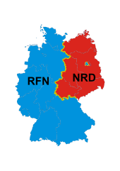
Deutsch: Karte der Innerdeutschen Grenze mit DDR und BRD (und Berlin). Zusätzlich sind die Grenzen der Bundesländer eingezeichneten. |
| Date | (UTC) |
| Source | |
| Author |
|
| This is a retouched picture, which means that it has been digitally altered from its original version. Modifications: polonizacja. The original can be viewed here: Karte Innerdeutsche Grenze.svg:
|
I, the copyright holder of this work, hereby publish it under the following license:
This file is licensed under the Creative Commons Attribution-Share Alike 3.0 Unported license.
- You are free:
- to share – to copy, distribute and transmit the work
- to remix – to adapt the work
- Under the following conditions:
- attribution – You must give appropriate credit, provide a link to the license, and indicate if changes were made. You may do so in any reasonable manner, but not in any way that suggests the licensor endorses you or your use.
- share alike – If you remix, transform, or build upon the material, you must distribute your contributions under the same or compatible license as the original.
Original upload log[edit]
This image is a derivative work of the following images:
- File:Karte_Innerdeutsche_Grenze.svg licensed with Cc-by-sa-3.0
- 2009-11-07T20:35:15Z JFR 592x801 (174591 Bytes) {{Information |Description={{de|Karte der [[:de:Innerdeutsche Grenze|Innerdeutschen Grenze]] mit DDR und BRD (und Berlin). Zusätzlich sind die Grenzen der [[:de:Bundesland|Bundesländer]] eingezeichneten.}} |Source=*[[:File:
Uploaded with derivativeFX
File history
Click on a date/time to view the file as it appeared at that time.
| Date/Time | Thumbnail | Dimensions | User | Comment | |
|---|---|---|---|---|---|
| current | 08:05, 13 May 2010 | | 744 × 1,052 (146 KB) | Kapitel (talk | contribs) | {{Information |Description={{de|Karte der Innerdeutschen Grenze mit DDR und BRD (und Berlin). Zusätzlich sind die Grenzen der Bundesländer eingezeichneten.}} |Source=*[[:File:Karte_Innerdeutsche_Grenze.svg |
You cannot overwrite this file.
File usage on Commons
There are no pages that use this file.
File usage on other wikis
The following other wikis use this file:
- Usage on pl.wikipedia.org