File:Kaart Grote Waard ca 1420 (2021 09 01).pdf
Jump to navigation
Jump to search

Size of this JPG preview of this PDF file: 799 × 288 pixels. Other resolutions: 320 × 115 pixels | 640 × 231 pixels | 1,024 × 369 pixels | 1,280 × 461 pixels | 2,560 × 923 pixels | 8,856 × 3,193 pixels.
Original file (8,856 × 3,193 pixels, file size: 13.33 MB, MIME type: application/pdf)
Captions
Captions
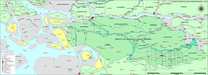
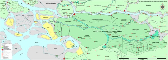
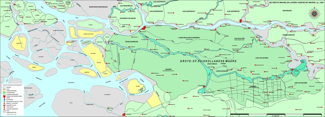
Map Grote Waard ca 1420 (2021 09 01)
Summary[edit]
| Description |
Nederlands: De kaart laat de Grote Waard en de latere Hoeksche Waard zien vlak voor de St. Elisabethsvloed van 1421.
English: The map shows the Grote Waard and the later Hoeksche Waard just before the St. Elisabeth Flood of 1421. |
| Date | |
| Source | Own work |
| Author | Willem Janssen |
Licensing[edit]
I, the copyright holder of this work, hereby publish it under the following license:
This file is licensed under the Creative Commons Attribution-Share Alike 4.0 International license.
- You are free:
- to share – to copy, distribute and transmit the work
- to remix – to adapt the work
- Under the following conditions:
- attribution – You must give appropriate credit, provide a link to the license, and indicate if changes were made. You may do so in any reasonable manner, but not in any way that suggests the licensor endorses you or your use.
- share alike – If you remix, transform, or build upon the material, you must distribute your contributions under the same or compatible license as the original.
File history
Click on a date/time to view the file as it appeared at that time.
| Date/Time | Thumbnail | Dimensions | User | Comment | |
|---|---|---|---|---|---|
| current | 06:49, 8 April 2022 | 8,856 × 3,193 (13.33 MB) | Willem Gabriel (talk | contribs) | Uploaded own work with UploadWizard |
You cannot overwrite this file.
File usage on Commons
There are no pages that use this file.
File usage on other wikis
The following other wikis use this file:
- Usage on nl.wikipedia.org