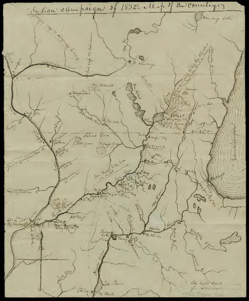
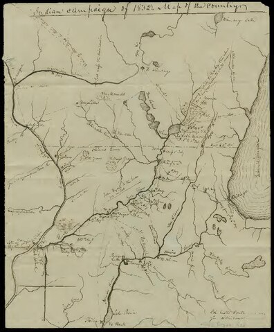
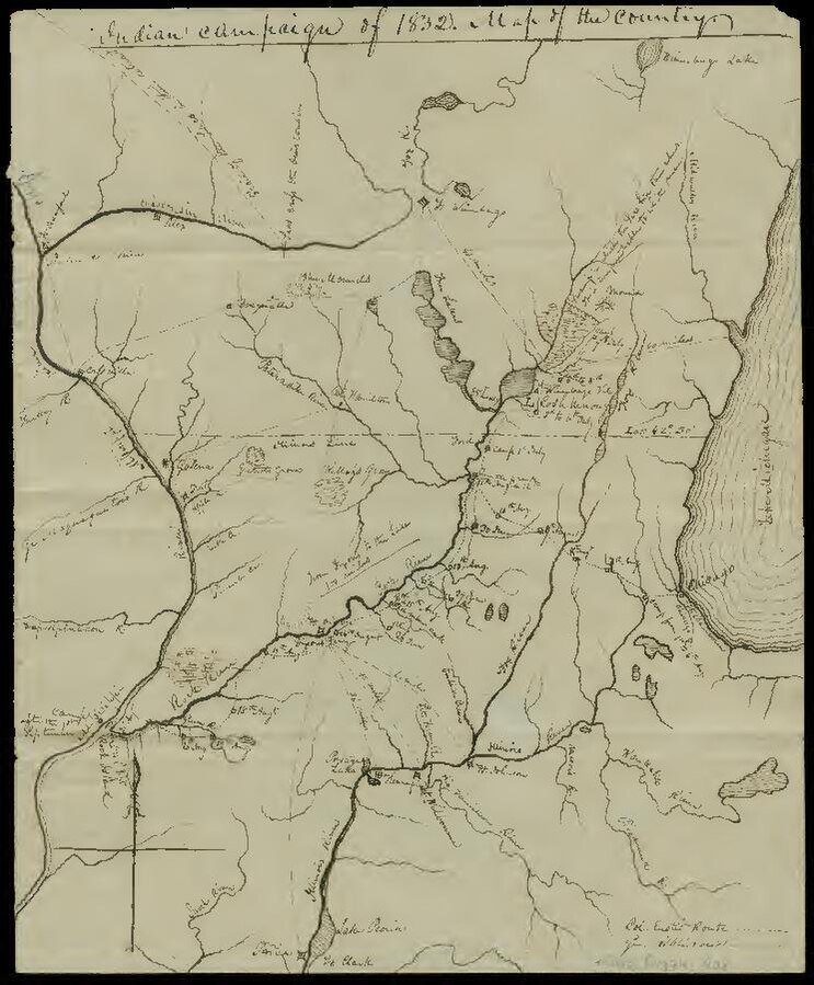
File:Indian campaign of 1832- map of the country (IA ruggles 408).pdf


Original file (743 × 900 pixels, file size: 156 KB, MIME type: application/pdf, 2 pages)
Captions
Captions
Summary
[edit]| Indian campaign of 1832: map of the country
( |
|
|---|---|
| Author |
Rose, Edwin |
| Title |
Indian campaign of 1832: map of the country |
| Publisher |
Newberry Library |
| Description |
Added title on verso: Map of Indian war of 1832, made by one who was there, Col. Edwin Rose. Pen-and-ink. Covers region in northern Illinois and southern Wisconsin roughly bounded by Lake Winnebago, the Kankakee River, Peoria, and Prairie du Chien. Identifies rivers, forts, towns, and distances between points. Details routes taken by U.S. forces during the Black Hawk War of 1832. Shows Gen. Henry Atkinson's June 28-July 9 route from Dixon's Ferry northeast along the Rock River and Lt. Col. Abraham Eustis's August 1-September 1 route from Chicago to Rock Island. Also identifies marshes of the upper Rock River where Sauk Indians led by Black Hawk were based and their retreat northwest from the Wisconsin River. Scale [ca. 1:1,675,000]. Subjects: Black Hawk War (1832); Indians of North America; Sauk Indians; Manuscript maps; Illinois; Wisconsin; What is the Midwest; Manuscript (Documents) |
| Language | English |
| Publication date | 1832 |
| Current location |
IA Collections: newberry |
| Accession number |
ruggles_408 |
| Source | |
| Permission (Reusing this file) |
The Newberry makes its collections available for any lawful purpose, commercial or non-commercial, without licensing or permission fees to the library, subject to the following terms and conditions: https://www.newberry.org/rights-and-reproductions |
Licensing
[edit]|
This work is in the public domain in its country of origin and other countries and areas where the copyright term is the author's life plus 100 years or fewer. This work is in the public domain in the United States because it was published (or registered with the U.S. Copyright Office) before January 1, 1929. | |
| This file has been identified as being free of known restrictions under copyright law, including all related and neighboring rights. | |
File history
Click on a date/time to view the file as it appeared at that time.
| Date/Time | Thumbnail | Dimensions | User | Comment | |
|---|---|---|---|---|---|
| current | 21:29, 1 January 2021 |  | 743 × 900, 2 pages (156 KB) | Fæ (talk | contribs) | IA Query "subject:maps date:[1000 TO 1869] " ruggles_408 Category:Old maps (COM:IA books#query) (1832 #653) |
You cannot overwrite this file.
File usage on Commons
The following page uses this file: