File:GMT France with altitudes.pdf
Jump to navigation
Jump to search

Size of this JPG preview of this PDF file: 600 × 600 pixels. Other resolutions: 240 × 240 pixels | 480 × 480 pixels | 768 × 768 pixels | 1,181 × 1,181 pixels.
Original file (1,181 × 1,181 pixels, file size: 145 KB, MIME type: application/pdf)
Captions
Captions
Add a one-line explanation of what this file represents
Summary[edit]
| Description |
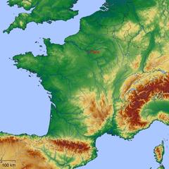
English: Map of France with altitudes |
| Date | (original upload date) |
| Source | Own work using:GMT and GTOPO30 (USGS) |
| Author | David.Monniaux |
| Other versions | Derivative works of this file: GMT France with altitudes.png |
| PDF development |
Licensing[edit]
| I, the copyright holder of this work, release this work into the public domain. This applies worldwide. In some countries this may not be legally possible; if so: I grant anyone the right to use this work for any purpose, without any conditions, unless such conditions are required by law. |
File history
Click on a date/time to view the file as it appeared at that time.
| Date/Time | Thumbnail | Dimensions | User | Comment | |
|---|---|---|---|---|---|
| current | 22:41, 24 May 2005 |  | 1,181 × 1,181 (145 KB) | David.Monniaux (talk | contribs) | |
| 21:02, 24 May 2005 |  | 1,181 × 1,181 (145 KB) | David.Monniaux (talk | contribs) | better colormap | |
| 22:13, 23 May 2005 | No thumbnail | 0 × 0 (42 KB) | David.Monniaux (talk | contribs) | Image:GMT_France_with_altitudes.png in PDF (original vector; PNG was obtained by rasterization) {{PD}} |
You cannot overwrite this file.
File usage on Commons
There are no pages that use this file.